Outdoor Links
Hike Arizona
Trip Planning Guide
Trip Report Index
Calendar of Events
Library
|
Aylors Caballo One-Way Hike Superstition Wilderness February 15, 2014 by Dave French |
|
|
Sixteen Trailblazers and guests met at 7:00 AM on a day that was forecast and, in fact, achieved a record high of 87 degrees in Phoenix on February 15. To get an early start on the heat, we quickly divided up into two groups of eight, swapped car keys, and drove in someone else’s car to our respective starting points. One group proceeded to the First Water Trailhead and the other to Peralta Trailhead. Dave lead the Peralta Group and Michael lead the First Water Group. Our objective was to meet somewhere in the middle, swap keys again and proceed to the other trailhead. |
 Peralta Trailhead: Jim, Chuck, Gary, Anikó, Monika, Dave, Kerry, Alex |
 First Water Trailhead: Michael, Funyung, George, Wayne, Bill, Nancy, Betty, Joseph |
 One more lug nut ... |
The Peralta Group encountered an unexpected challenge as we drove into the trailhead parking area and the trailhead steward notified us that we had a flat tire. We parked and sure enough the right rear tire on Bill’s jeep was rapidly deflating. Alex sprang into action and quickly changed the tire. |
|
We departed the trailhead about 8:15 and quickly began the climb to Fremont Saddle. This part of the trail is 2.6 miles in length and has an elevation gain of over 1300 feet. It is the hardest segment of the entire 12 mile trek. The scenery in Peralta Canyon is spectacular. |
 Calico Rock brightens our climb up to Fremont Saddle. |

|
|
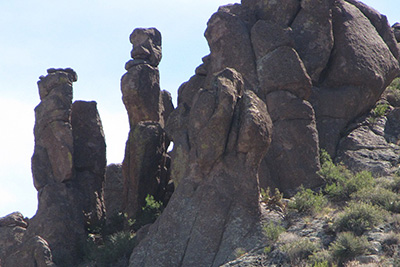
| Numerous window rocks have been formed by weathering and erosion. | |
|
As we neared the saddle, trip leader Dave caught his toe under a stationary rock and fell hard, hitting his head on another rock. The Trailblazers and Dave’s daughter Kerry and son-in-law Alex quickly sized up the situation, cleaned the wound and got Dave back on his feet. This is a perfect example of why it is so important to have first aid supplies with you and fellow hikers. We proceeded the short distance to the saddle and took a second group photo. |
 Fremont Saddle: Chuck, Jim, Monika, Kerry, Anikó, Gary, Dave, Alex. |
 The Superstition Mountains are famous for their hoodoos. |
 Peralta Canyon, from the top. |
|
After consultation, Dave decided that his wound was serious enough that he should return to the starting trailhead and seek medical attention. He and his daughter and son-in-law proceeded back down the Peralta Trail and found urgent care in Gold Canyon. With eight stitches in Dave’s head, they were able to return to the trailhead in time to meet the group that had hiked from First Water. The group which now consisted of eleven hikers squeezed into two vehicles and returned to the meeting place. Chuck took over as hike leader and filed the supplemental report below: |
 Dave is going to be all right. |
 Southbound hikers pause by Black Mesa: Funyung, Betty, Wayne, Nancy, Bill, George, Michael. |
 Key exchange near Piñon Camp: Gary, Jim, Funyung, Wayne, George, Michael, Bill, Chuck, Nancy, Betty, Anikó, Joseph, Monika. |
|
Supplemental Report: Northbound Hike by Chuck Parsons |
|
After taking a short rest and refueling break at Fremont Saddle and enjoying the great views of Weavers Needle and East Boulder Canyon, the Peralta Group splits up. We say our goodbyes to Dave, Kerry, and Alex, as they head back to Peralta Trailhead, and the remaining five in the Peralta Group (Anikó, Monika, Jim, Gary, and Chuck) begins the long descent down Peralta Trail toward the base of the needle. It’s always interesting to note that the overwhelming majority of hikers who trek up and down the Peralta Trail make Fremont Saddle their turnaround point and head back to the trailhead from there, while very few bother to continue beyond the saddle for a closer look at Weavers Needle. I have hiked this trail many times over the past 30 years or more, and that aspect of the hike has never changed. Apparently old habits are hard to break. The Peralta Trail begins to drop rapidly from the north slope of Fremont Saddle, as it goes into a series of switchbacks before finally emerging from Peralta Canyon and depositing us along the western wall of East Boulder Canyon. A mile or so into our 450-foot descent from the saddle and we are at last on the floor of East Boulder Canyon, approaching the western face of Weavers Needle. The needle opens up dramatically as we draw nearer for a view that few hikers ever see, making a seemingly miraculous transformation from what hikers see at the saddle as it reveals two separate spires, the tallest thrusting upward over 1200 feet above the canyon floor. Here we keep a lookout for rock climbers, who sometime camp out overnight on the summit of the needle after making their precarious, but calculated, ascent up this steep, sheer-walled formation. But on this day we do not spot any climbers, at least not on the west side of the needle. |
 Looking northward from Fremont Saddle. |
 Looking southeast from Dutchman’s Trail. |
| Ever-changing views of Weavers Needle as we walk north on the Peralta Trail: |

|

|

|
|
Named after 19th Century Indian scout, miner, and legendary mountain man Pauline Weaver, Weavers Needle is the most prominent landmark in this part of the Superstitions for miles around. Stretching skyward to 4,553 feet, the needle is actually an ancient volcanic plug, the harder interior of a volcano whose exterior walls have long since eroded away in this tortured landscape created by millions of years of violent volcanic eruptions from at least five known volcanoes followed by millions of additional years of wind and water erosion, the handiwork of nature’s master sculptures. About midway between Weavers Needle and the junction with the Dutchman’s Trail, we finally link up with the First Water group and stop for a well-deserved rest and lunch break in the shade of the canyon, as well as the critical key exchange. The First Water group is making excellent time, but we were a bit delayed by changing a flat tire on Bill’s jeep upon arrival at Peralta Trailhead in addition to Dave’s incident just below Fremont Saddle. As Jim diplomatically puts it, the poor mountain lion was in worse shape than Dave for the encounter. Dave is one tough hombre. Anyway, that’s our story for now and by golly we’re all sticking with it. After lunch and the key exchange we set out once again. Next stop will be the critical Peralta Trail/Dutchman’s Trail junction. The very dry conditions and scant wildflowers along the trail serve as a stark reminder of the complete lack of rainfall in Arizona’s lower deserts since about mid-December of last year. But life goes on and despite the lack of rain there is an abundance of plant life throughout East Boulder Canyon, including mesquite, creosote, jojoba, paloverde, sumac, desert willow, scrub oak, Pinyon pine, and Arizona madrone, offering temporary patches of shade along the trail. Much of the Superstitions receive more rainfall, on average, than the Phoenix area, and the network of creeks and washes that crisscross the canyon floor helps capture additional water. We eventually reach the trail junction with the Dutchman’s Trail and start heading west toward First Water. Although the day is getting warmer as the afternoon wears on (90 degrees in the sun according to my thermometer), a cooling breeze and periodic patches of shade along the trail offer relief and help keep us going. We soon reach Parker Pass, the high point on this stretch of the Dutchman’s Trail, and take a short break. Just 2.5 miles to go from here in a northwest direction to First Water Trailhead. Despite being tired after hiking almost ten miles, we make very good time from the pass and finally arrive at First Water about 3:30 in the afternoon. After cleaning up a bit and quenching our thirst with fresh cold water reserves, the five of us leave in two vehicles to meet the rest of our group for a late lunch at BJ’s Restaurant & Brewhouse, just west of Power Road near our meeting location earlier this morning. It’s been yet another great hike in the Superstition Wilderness. Thanks for putting this trip together, Dave. |
|
Supplemental Report: Southbound Hike by Michael Humphrey |
|
|
Eight Trailblazers are ready to go at 8:00 AM. We head out into the rising sun on the Dutchman’s Trail. This nice thing is that, due to the local rock formations, we pass into and out of shadows. So this is a cool walk. Soon enough, the day will heat up to above 80 degrees. We pass the junction with the Second Water trail and continue on past the junctions with West Boulder, Black Mesa, Boulder Canyon, and Bull Pass Trails. We now get to the Aylors Caballo Camp, which is just to our right. Aylors Arch is up high on the top of the ridge line. |
 A weird rock seems to be pointing our direction. |
 Aylors Arch. |
|
We soon get to the turn off for Peralta Trail. The day is starting to heat up. I try to reach the second group over the radio, but no response. |
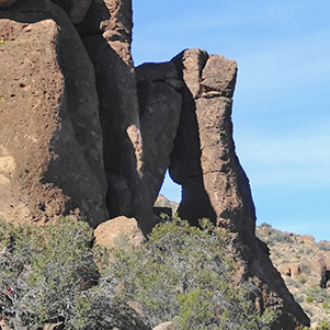
 A hidden arch lurks amid those hoodoos. |
So we continue up toward Fremont Saddle. The slope on this side is easier than the other side. Weavers Needle is to our left as we continue up. There is a hidden arch in the rocks to our right as we continue up. We try the radios again. The second group has gotten to the top of Fremont Saddle, so they can hear us. Weavers Needle keeps changing shape as we pass the three basalt plugs that make the needle. |
 Three spires of Weavers Needle. |
 Don’t think I’ll stand underneath it. |
|
Then we meet up with the other group just as we are passing though a spot with shade, so this will be the lunch spot. We exchange keys, in which we give them two keys and get one back. Dave has the other one, to go get patched up. Just before we got to Fremont, we meet up with a two persons who were going to climb Weavers Needle and spend the night on top. Continuing up to the saddle, we can see some balanced rocks. At this point we make our last radio contact with the other group and head down the hill. Peralta Canyon has many different plants and rocks as we continue down. When we get to the parking lot, Dave is back with Bill’s jeep. We have beer and water before continuing to BJ’s. |
|||||||||||||||||||
 BJ’s: Nancy, Funyung, Bill, George, Anikó, Monika, Jim, Gary, Chuck, Michael, Dave, Kerry, Alex. |
|||||||||||||||||||
|

 Top of Page
Arizona Trailblazers Hiking Club, Phoenix, Arizona
Comments? Send them to the AZHC .
updated June 2, 2020