Outdoor Links
Hike Arizona
Trip Planning Guide
Trip Report Index
Calendar of Events
Library
|
Sycamore Rim Trail Williams September 7, 2013 by Jim Buyens |
|
Sycamore Canyon is truly a natural wonder. It’s located in Arizona’s Red Rock Country, second in size only to the famous Oak Creek Canyon. Since 1984 it’s been an official wilderness area, and is therefore well-preserved and free of bicycles and motor vehicles.
I hiked this trail twice last year, once on August 19 and again on September 15. Why twice, and so close together? The trail was just that spectacular! Not only did it have mild terrain and natural scenery, but numerous waterfalls, including a triple-decker a hundred feet high!
It turns out, though, that catching the waterfalls in action is a tricky business. If it hasn’t rained enough lately (and that’s most of the time) they’re dry. That was the case on my September 15 visit. Nevertheless, I was determined to try again. September 7 was the closest available date to last year’s waterfall hike so I took it and sixteen more trailblazers joined me.
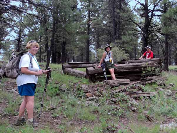
 Jim, Sandra, Rockwell, Eileen, David, Vanessa, Yanis, Florence, Linda, Anikó, Laurie, Quy, Ed, Cathy, Michael, Edith, and Bill ready to go. [photo by Jim] |
The trail is a loop just under 12 miles long, and it consists of four main segments.
- KA Hill, which require about 500 feet of climbing.
- The Pomeroy Tanks, a connected series of ponds, each with water falling to the next.
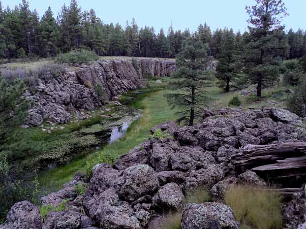
- The Sycamore Canyon Rim, which offers spectacular views of the canyon.
- Sycamore Creek, which has created another beautiful collection of rock formations and tanks. This segment also features the remnants of two log cabins.
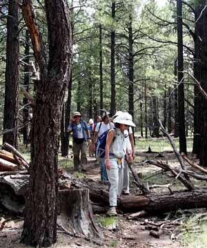
 On the way, before starting the climb to KA Hill. [photo by Jim] |
 A sizable print, though we didn’t spot any actual animals. [photo by Jim] |
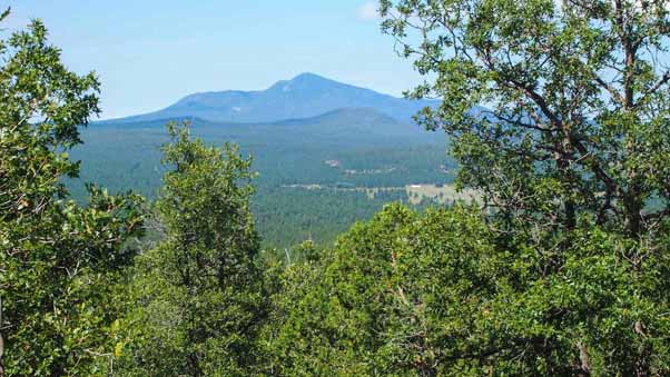 A great view from the top of KA Hill [photo by Quy] |
 A swarm of ladybugs. [photo by Quy] |
 Vanessa steps over a log. [photo by Quy] |
 Yanis and Vanessa take a break. [photo by Quy] |
The initial trek up KA Hill was a bit steep in places but everyone made it to the top with no problems. It helped that we did this segment first, while we were still fresh, and knowing it would account for about of half of the elevation for the whole hike. And of course the way back down was much easier.
When we got to the Pomery tanks I was filled with anticipation but alas, all the waterfalls were dry. The tanks had water in them, though, and the rock formations, even dry, were captivating.
 The Pomeroy Tanks are a series of ponds connected by waterfalls. Unfortunately the waterfalls weren’t flowing that day. [photo by Eileen] |
 When there’s enough rain, the rocks at the right become a waterfall. The first Pomeroy tank is at the left. [photo by Jim] |
 The tanks continue onward toward the south. [photo by Jim] |
 This was the first of many water crossings. [photo by Jim] |
 When the water’s running is gushes down this trough. [photo by Jim] |
 Don’t trip and get wet!!! [photo by Jim] |
 Another crossing, this time over a land bridge. [photo by Eileen] |
 The grass here must have grown when the weather was dry, and then got submerged under rainwater. [photo by Quy] |
 There were no waves in the water, here, only in the rock. [photo by Jim] |
 Another crossing. Dry land was only a hop, a skip, and a jump away. [photo by Quy] |
 I told you there were lots of crossings. [photo by Jim] |
Sycamore Falls is a truly imposing structure; it the rocky streambed suddenly drops 100 feet, and over the years it’s carved out a spectacular canyon with vertical walls on three sides. It’s also about halfway through the hike, and so there we stopped for lunch.
Although the falls was dry (or perhaps because it was dry) we enjoyed the sight of several rock climbers scaling the canyon. They had safety ropes, of course, but it was still amazing as they grappled their way up the canyon walls.
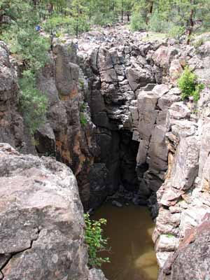 Even dry, Sycamore Falls was undoubtedly the most spectacular spot on the hike. [photo by Jim] |
 A rock climber dangles over the falls. You can barely see his buddy at the top. [photo by Eileen] |
 The trick is not to use or need the rope and yes, he did make it to the top. [photo by Jim] |
 Hmmm, where to go from here. It looked a lot easier on The Adventure Channel... [photo by Quy] |
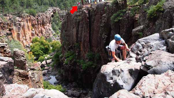 Another climber makes it to his objective. The arrow points to a few hikers from our group. [photo by Quy] |
 Yanis enjoys the view. Careful how you get up, there... [photo by Jim] |
 Yanis loosens up while Michael takes a break. [photo by Jim] |
 Bill captures the moment. [photo by Jim] |
 Eileen finishes scaling the canyon wall. [photo by Eileen] |
 Or not. [photo by Jim] |
 I take in the scenery. Edgy stuff!! [photo by Jim] |
 Edith pauses to reflect. It was quite a way down to the water, though. Notice the red rocks. [photo by Jim] |
Eventually, of course, it was time to get going and finish the hike. Although this trail segments parallels the rim of the canyon, it’s gently wooded and not that close. To get a good look of the canyon itself, you have to pick a spot and go off-trail for fifty or a hundred feet. The views are there, though, for anyone who takes time to look.
 Back on trail, now, with another log to straddle. [photo by Quy] |

|
Anikó discovers a geocache in a genuine (if somewhat weathered) Captain Jack Sparrow lunchbox. Avast! [photo by Jim] |
 Eileen gives her feet a break. [photo by Quy] |
 Another geocache for Anikó, this time in an ammo box. [photo by Jim] |
 The third segment of the trail paralleled Sycamore Canyon, providing views like these. [photo by Jim] |
 Another view from the canyon rim. [photo by Jim] |
 Some guardists or reservists, I suppose, honing their mountaineering skills. [photo by Jim] |
 These guys need a break, too. They’re about halfway down the canyon wall here. [photo by Jim] |
The fourth and final segment was Sycamore Creek, a lush wooded segment with mostly-gentle ups, downs, tanks, and crossings. Most people were getting pretty tired by then but we still enjoyed the scenery and the sense of history provided by the two cabins. You might say we kept on hiking because we knew it’d feel so good when we stopped!
 The last segment of the trail runs along Sycamore Creek, which once again creates a series of tanks. [photo by Quy] |
 Lilly plants aren’t native to Arizona, but the pads and flowers are a rare treat anyway. [photo by Quy] |

|
A beautiful spot along the trail.
Can you spot the hikers? |
 This is the first of two cabins near the end of the hike. When you see the cabins, you know you’re close to home! [photo by Eileen] |
 Still paralleling (and occasionally crossing) Sycamore Creek. [photo by Eileen] |
 It’s hard to imagine that Sycamore Canyon began as a shallow depression like this but I guess it did! [photo by Eileen] |
 Here’s Bill showing off his new Bucky Badger shirt near the second cabin. He says the roof leaks. [photo by Eileen] |
 Vanessa takes a final break before completing the hike. [photo by Eileen] |
 Yay, we’re back where we started from! Great hike, and we even beat the rain! [photo by Quy] |
After the hike a few people went directly home but most of us headed into Williams for conversation, camaraderie, and a great Mexican dinner at Pancho McGillicuddy’s, a wonderful old spot that’s in the National Register of Historic Places. Great hike!
| Hike Statistics | |
| Total distance: | 11.7 miles |
| Moving time: | 4:42 |
| Stopped time: | 1:51 |
| Average speed moving: | 2.5 mph |
| Average speed overall: | 1.8 mph |
| Trailhead elevation | 6703 feet |
| Maximum elevation: | 7263 feet |
| Total ascent: | 1019 feet |
 Top of Page
Arizona Trailblazers Hiking Club, Phoenix, Arizona
Comments? Send them to the AZHC .
updated January 20, 2020