Outdoor Links
Hike Arizona
Trip Planning Guide
Trip Report Index
Calendar of Events
Library
|
Anderson Mesa Day Hike Flagstaff June 25, 2005 by Ted Tenny |
|
 Trailblazers on passage 31 of the Arizona Trail. |
|
We started north on the Arizona Trail from Marshall Lake Trailhead. A dozen breezy hikers enjoyed this Flagstaff adventure: Michael Humphrey, Debbie M., Laurel Curvin, Cody Kuenzi, Frank Kaylor, Carol Crawford, Doug East, Ken Jalen, Emie Sorongon, Kay Lyons, Joe Michalides, and hike leader Ted Tenny. The weather was partly cloudy with a light breeze. |
|
The trail took us northwest across Anderson Mesa, a broad grassy upland dotted with widely spaced trees. The open character of the terrain let us make good time as we stopped near Marshall Mesa Tank for group pictures. The Arizona Trail through this region is marked with little signs, but is usually the most prominent trail. For our lunch stop we found a shaded area with several downed logs to serve as benches. For a few moments the sky looked like it might rain, but then the sun came back. Everyone had a leisurely lunch before making our way to the edge of Anderson Mesa. The approach to Walnut Canyon gave us a fine view of Humphreys Peak. There were colorful rocks along the trail as we turned north and started our descent into Walnut Canyon. Cliffs on the north side of the canyon are white, while those on the south side are variegated, showing taffy-like patterns striped with desert varnish. |
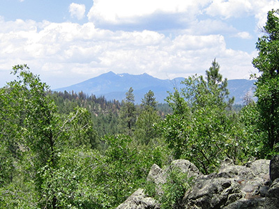 San Francisco Peaks dominate the skyline. 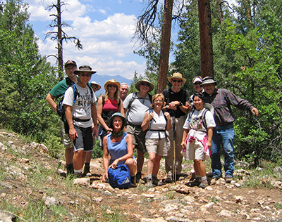 We finally topped out on the trail. |
|
The actual canyon crossing was surprisingly easy – just a little dip in the trail at this point. Ahead is an important junction: the Arizona Trail turns north and then east toward Walnut Canyon National Monument. But we’re headed the other way, so we turned left and hiked upstream toward Sandys Canyon. |
|
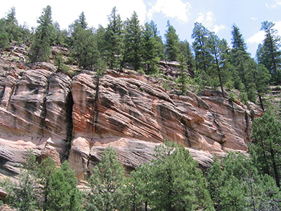 Banded rocks decorate Walnut Canyon. |
We had met only a few hikers up to this point. But on in to Sandys Canyon Trailhead there were a number of hiking groups. The first part of the trail is an easy walk along the streambed. Getting out of Sandys Canyon is a respectable climb. Near the top Ted waited in the shade for everyone to catch up. There were vines growing among the trees and rocks. Poison ivy. He didn’t stay long. |
|
The trail turns southeast. We walked past a big rockslide of boulders with lichens and trees growing on them. Tall pines in the foreground and the San Francisco Peaks in the background make it a fitting end to a very scenic hike. |
|
 Top of Page
Arizona Trailblazers Hiking Club, Phoenix, Arizona
Comments? Send them to the AZHC .
updated August 23, 2018