Outdoor Links
Hike Arizona
Trip Planning Guide
Trip Report Index
Calendar of Events
Library
|
Mt. Graham Car Camp Pinaleno Mountains June 6-8, 2003 by Chuck Parsons |
|
|
Leaving the hot, burning desert floor around Safford, Arizona behind us, Laurie Jacobson, Beth Baumert, and I begin the long, steady ascent up the Swift Trail (State Highway 366), one of Arizona’s most beautiful and scenic drives. Designated a state scenic parkway in 1993, the Swift Trail steadily forges its way up the southeastern slopes of Mt. Graham in a seemingly endless series of harrowing switchbacks and hair pin turns, as it carries us up from Sonoran desert scrub at the 3,500 foot base to alpine spruce-fir forests near the top at 10,720 feet. This ninety-minute, thirty-five mile drive into the very heart of southeastern Arizona’s highest sky island – the Pinalenos – takes the traveler through an incredible 7,000 feet of elevation change, comparable to driving from Mexico to Canada through five diverse life zones. It is the largest elevation change from base to peak of any of Arizona’s mystical sky islands. |
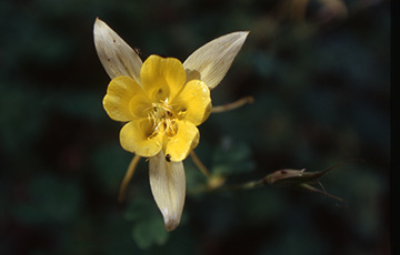 Golden Columbine in full splendor. Looking back down at the cascading series of tight turns and switchbacks below us, we marvel at the hard work and engineering abilities of the hundreds of young men in the Civilian Conversation Corps, who toiled during the 1930s to build this road and most of the major trails that originate from it. The CCC was responsible for building many of the roads, bridges, trails, buildings, and infrastructure of National Parks and National Monuments across the country during the depression years of the 1930s. The time is 1:00 PM, as we pull into Cunningham Campground, nestled in a forest of pine and aspen at an elevation of 8,800 feet. We settle into sites #1 and #2, as we unload our camping gear, set up the tents that will serve as our homes for the next couple of nights, and break out some lunch. We don’t tarry too long after lunch, since Laurie is really anxious to get in some quality hiking time before dinner. We hit the Grant Goudy Ridge Trail at the end of our campground road at 2:30 PM and begin hiking through a thick forest cover of pine, Douglas fir, and aspen. |
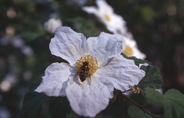 A busy bee gathers nectar and pollen from a large Apache Plum blossom. Beth later identifies these trees as Apache Plum, which are also in abundance around our campground. It soon becomes obvious that this is not one of the primary maintained trails in the Mt. Graham trail system, as the trail gradually becomes rougher and more impassable the further we travel, with numerous fallen trees blocking the path and requiring us to go over or around them. We are, however, rewarded with some very scenic views from the ridge, including Sulphur Springs Valley and Fort Grant, far below us to the south. |
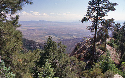 View of Gila River Valley from the Grant Goudy Ridge Trail. |
Fort Grant was a major military post during the Indian Wars of the 1870s and 1880s, when the U.S. Calvary was at war with the Apaches. It was abandoned by the Calvary in 1905 and was eventually converted to a state prison. From our bird’s eye viewpoint high on the ridge, it almost looks like a resort, with its landscape of neatly manicured lawns, large shade trees, and well-maintained buildings. |
|
Hiking the full eight-mile length of this ridge trail will eventually deposit the hiker at the door step of Fort Grant, however, after approximately two miles of hiking and working around fallen trees, the trail gets too rough to proceed, and we decide to turn back. By 4:30 PM we are back at the trailhead, where we are greeted by Dave and Yu-Ling Langford, who had arrived at the campground about an hour earlier. Dave, our resident trout fishing expert, was wondering where the closest trout stream was located. |
|
I fully expected the two of them to be prowling the shores of Riggs Flat Lake, about eight miles up the road from our campground, until they had caught their limit of lake trout. That not being the case, visions of fresh caught grilled trout for dinner quickly begin to fade away. We settle instead for grilled chicken, chilidogs (hope I am not any too close to that tent tonight), pasta and chicken, and salad, washed down by tea and ice cold beer. |
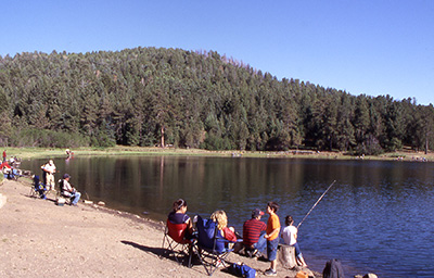 Hopeful anglers try their luck along the shores of Riggs Flat Lake. |
|
As the sun drops lower to the horizon, the chill of the coming night begins to descend on our 8,800-foot campsite, and we start thinking seriously about preparing a campfire. This will be a welcome change from our Chiricahua camping trip a few weeks ago, when we were not allowed to have campfires because of the drier conditions and extreme fire danger in that area. Both Dave and I have brought along plenty of firewood this time to keep fueling a good campfire that would ward off the night chill and keep the bears away for a couple of nights on Mt. Graham. In no time at all, we have a roaring fire going and sit back to soak up the heat and swap a few stories. Absorbing a lot of smoke in our clothing from the fire, we wonder – do bears prefer smoked meat? Then there’s the story of the effectiveness of pepper spray and bear bells in discouraging a bear attack. If you come across bear droppings that smell suspiciously of pepper and contain shiny bells, it is a good bet that tactic did not work for some hapless hiker. Hey – what was that noise I just heard? By now, both Beth and Laurie are thinking of sleeping in Laurie’s 4-Runner, but wind up settling for their tents in the end, carrying hefty wooden clubs with them, just in case. The night grows longer, and by about 9:45 PM, we are wondering when our last three campers will be arriving. Since they had left the valley around 5:30 PM, we did not expect to see them until at least 10:30 or later. Discovering that Yu-Ling has brought along a field test Iridium phone, I suggest that we try to reach Joe Michalides on his cell phone. We try without success, not sure if cell coverage is even available in the area. Within minutes, Joe pulls into camp and informs us that his cell phone is turned off anyway. Within five minutes of Joe’s arrival, Richard DeSouza and his wife, Rochelle, are the last of our arrivals for the night. After they get set up, we all sit by the dying embers of the campfire and wind down for the evening. Tomorrow is going to be a big day, with a ten-mile hike in the works. Laurie returns from the restroom at the end of our campground road, swearing that she heard a large animal of some kind make a dash for the woods, as she approached, flashlight in hand. Now we all really start to wonder, as we retire for the night, with visions of hungry, marauding bears rampaging through our campsite in search of food. |
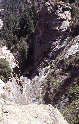
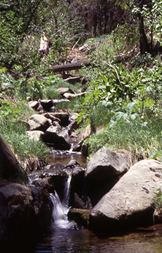 Ash Creek tumbles and cascades its way down to the falls. |
Saturday morning dawns bright and clear in the Pinalenos. It was a long, restless night for some of us, with the winds howling through the treetops for much of the night, strange, unexplained noises coming from the black void of the surrounding forest primeval, and a chorus of extremely vocal birds that must all be suffering from chronic insomnia. The temperature stands at a brisk, cool 55 degrees, as we sit down to enjoy breakfast and discuss today’s hike. We will be hiking the Arcadia Trail this morning, which runs for 5.1 miles between the Shannon and Arcadia Campgrounds, down the road from our location. This is one of the most popular hiking trails on Mt. Graham and enjoys the designation of a National Recreation Trail, which means that it falls into a very select group of premier hiking trails in the country. Breakfasts over, we all pile into two vehicles for the short drive down the Swift Trail to Shannon Campground. |
|
By 9:00 AM we are all standing at the Arcadia Trailhead sign at the end of the campground, posing for our group picture – eight eager trailblazers ready to hit the trail and put some mileage behind us. |
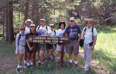 Rochelle, Richard, Yu-Ling, Dave, Laurie, Beth, Joe, and Chuck at the Arcadia Trailhead. |
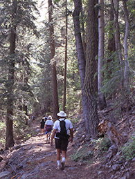 Hikers starting down the Arcadia Trail. |
|
At 9,100 feet, the trail starts out on the only reasonably level portion that we will see today, as it traverses Shannon Park, a grassy basin filled with towering ponderosa pines, Douglas and white fir, Engelmann spruce, and aspen. The large scattered stumps we see from time to time are all that remain of fallen forest giants, evidence of the heavy logging activity that occurred throughout the early 1900s, when seven sawmills operated full time on Mt. Graham. The trail soon starts climbing, as we gain an additional 500 feet of elevation, before reaching the Heliograph Peak Junction at 9,600 feet and one mile from the trailhead. Heliograph Peak, at 10,028 feet, has a fire lookout tower that provides a panoramic view of the southern Pinalenos and the Gila River basin. During the 1880s Heliograph Peak served as a critical part of a signaling network in the Pinalenos highest peaks, used by the Army Signal Corps to flash mirror signals during the Apache Wars. |
|
We push on beyond the junction, considering hiking the one-mile spur trail to the peak after returning from the Arcadia end of the hike. From this point, it is almost all downhill, as we start descending a total of 2,900 feet before reaching Arcadia Campground, sitting at 6,700 feet at trail’s end. The trail drops steadily in a long series of switchbacks, and we soon find ourselves hiking through an extensive, lush green thicket of knee-high bracken ferns, growing in a large burn area. Charred and blackened stumps and hollowed out blackened trunks of standing or fallen trees serve as a stark reminder of the periodic forest fires that rage across these peaks during the summer months. Clearing the burn area, the trail becomes steeper and rougher in places and begins to follow a ridgeline with almost sheer drop-offs at trail’s edge. Looking over the edge, you can’t help but wonder how far you would fall, before coming to a stop against some obstacle. |
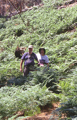 Joe and Beth in waist-high Bracken fern. |
|
From time to time enormous granite boulders, the size of houses and weighing thousands of tons, lie at either side of the trail, one split down the middle on both sides of the trail. We wonder about their origin, as we continue to press onward and downward…and downward. At 2.8 miles we reach the Noon Creek Ridge trail junction, and are now well past the half way point in our relentless descent toward Arcadia Campground. We definitely have our work cut out for us on the return trip back to Shannon, when we are going to have to gain back all of this elevation we are now losing. As we continue to descend, the forest cover gradually converts to a broader mix of oaks, alders, walnuts, and Arizona madrone. We occasionally see evidence of the pine bark beetle infestation that is currently raging across Arizona’s drought stricken pine forests, in the form of numerous brown and dried out ponderosa and pinyon pines scattered across the distant slopes, standing out like ghostly images in the forest. This is evidently also a very good year for butterflies, since we have seen many of them along this path, especially the large and colorful tiger swallowtails, as they flit about gracefully in search of a sip of sweet nectar. Another insect in apparent abundance this year are the thousands of gnats that are in most of our faces along much of this trail today. Arcadia Trail changes continually on our descent, from rough and rocky to relatively smooth, in places a soft, easy carpet of deep pine needles. As we drop in elevation, the forest begins to open up, exposing more of the trail to direct sunlight and warmer temperatures. Other than the two hikers who had passed us up just beyond the trailhead, we have not seen anyone else on this trail today, which seems a little unusual for a normally popular trail on a Saturday morning. A little past 11:30, Joe, Beth, and I finally reach trail’s end and catch up with the rest of our group at the Arcadia Group Picnic Area, where we all break for lunch at some shady picnic tables – no one else in sight. After lunch, Dave and Yu-Ling inform us they are not going to make the return hike back to Shannon with the group. Instead, they will hitch a ride back to our campground, retrieve their fishing gear, and head out to Riggs Lake for an afternoon of trout fishing. As we start the long, uphill hike back, I believe some of us had the same thought in mind. Let’s see now – catch a quick ride back to camp, rest, do some trout fishing, relax and take it easy, or trudge back up through dozens of switchbacks, while gaining 2,900 feet of elevation over 5.1 miles of tough trails? Apparently, the rest of us must have gotten just a little too much sun on that last mile or so of trail on the way down, since we decide on the second option and start eating up elevation on the long return trip back to Shannon. The return hike is a long and arduous process, but we are very fortunate to have enough cloud cover to keep the hot sun off of us for most of the hike. By 3:30 we are all assembled back at Shannon Campground, where Rochelle treats us to a box of delicious Krispy Kreme glazed donuts – a very welcome sugar hit that we all needed. Laurie is the only one of us with enough energy left over at the Heliograph Junction to actually make the two mile round trip to Heliograph Peak, where she was a bit disappointed with the view, since she wasn’t able to go up into the fire lookout tower. Back at Cunningham, some of us decide to head out to Riggs Lake and watch Dave and Yu-Ling haul in tonight’s dinner. We meet them on the way, where they inform us they caught two trout – not quite enough to feed this hungry crowd tonight. Back at camp, we clean up and rest for a bit, before making preparations for tonight’s potluck dinner, which apparently will not be including fresh grilled trout. However, we have more than enough other great entrees to go around, including a fresh garden salad, pasta salad with Italian sausage, a marinated three-bean salad, a corn and salsa dip, grilled corn on the cob, large, crusty loaves of sourdough and olive/onion bread, and home-made oatmeal- raisin cookies – all washed down with ice-cold beer and a large bottle of California red wine. How can you beat this combination – good friends, good food and drink, and good conversation, all in the picturesque, forested setting of Mt. Graham at sunset? Time to get that campfire going once again, and we have plenty of wood to burn tonight, since we don’t want to haul any more of it back down the mountain than necessary. Sitting around a nice, roaring campfire, we discuss bears (again?), fishing, food (you gotta be kidding!), and tomorrow’s hike to spectacular Ash Creek Falls. We rise to a chilly 50 degrees on Sunday morning, serenaded once again during much of the night by our melodious, insomniac feathered friends of the forest. Say – just who is responsible for getting the morning campfire going, anyway? No bear noises or sightings to report during the night, and the winds were pretty calm for a change. Most of us got a fairly good night’s rest, especially those still dead to the world and running a saw mill in their tents. Actually, we probably owe the tent flappers a large thank you for keeping the bears away during the night. No bear in his right mind would approach our campsite with that noise. Breakfasts out of the way, we get our hiking gear ready and prepare for the day’s venture to Ash Creek Falls. Joe indicates that he is packing up and leaving early for the valley, while Dave and Yu-Ling are planning on heading out later and will probably meet us somewhere along the trail. Rochelle informs us that she has had an upset stomach most of the night, and although she feels a little better now, does not want to risk getting sick on the trail. She will stay behind and wait for our return. The rest of us depart and drive up the Swift Trail to the trailhead, located at the Columbine Public Corrals & Campground, three miles beyond Cunningham and just past the now-closed Mt. Graham Visitor’s Center. At 8:20 AM on a beautiful, clear and cool Sunday morning in the Pinalenos, we assemble at the Ash Creek Falls Trailhead, ready to begin our 2.5-mile hike down to the falls. The trail will drop from 9,500 feet in elevation to 8,100 feet at the falls. I tell everyone this will be a cakewalk, compared to yesterday’s venture on the Arcadia Trail, which was really the equivalent of hiking out of the Grand Canyon from Indian Gardens, except for the higher elevation and absence of the fifty pound backpacks that we are usually toting out of the canyon. Our now small group of four starts down the trail, among towering ponderosa pine, Douglas-fir, blue spruce, and scattered stands of quaking aspen, whose leaves almost seem to be quivering in the light breeze blowing through the overhead canopy. Hiking these high forest trails of the Pinalenos gives one a sense of traveling through a dense, dark, forest primeval perhaps more than anywhere else in Arizona, especially when hiking alone for long stretches. You hear a branch snap and crash to the forest floor, catch the distinct sound of snapping twigs under foot, or detect the sound of something moving rapidly through the underbrush, and immediately look around to see where the noise is coming from. You wonder if it is coming from a two-legged or a four-legged source and see nothing but hundreds and hundreds of tall tree trunks surrounding you, standing like mysterious, ghostly giants – silent witnesses to all that goes on around them, as you peer intently into the vast and foreboding depths of the deep, dark forests of Mt. Graham. |
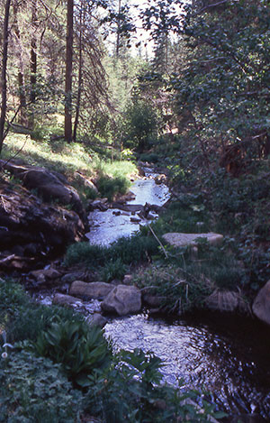 Ash Creek meanders peacefully through the forests of Mt. Graham. |
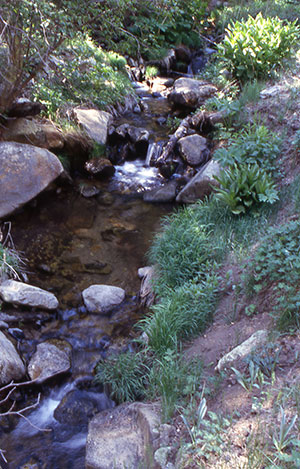 Just a few of the many small waterfalls along Ash Creek. |
|
A half-mile from the trailhead, we reach the Webb Peak Junction, where a 2.7- mile loop trail takes the hiker to the 10,030 summit of Webb Peak and its fire lookout tower. Pressed for time today, we will have to consider the Webb Peak Trail on a future trip to Mt. Graham. Shortly beyond the junction, we reach the headwaters of Ash Creek, one of the few permanent watercourses in southern Arizona and home to the rare native Apache trout. The life-giving waters of Ash Creek allow for a thick growth of skunk cabbage, raspberry bushes, and more shades of green than can be imagined in the rich and diverse plant life that thrives along the banks of this creek. As we continue descending, the trail crosses the creek from time to time, and we are treated to a number of small waterfalls cascading over large boulders in the creek bed. |
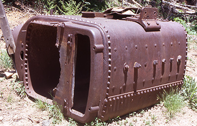 A large, rusted boiler sits next to the trail and Ash Creek. |
After one creek crossing about a mile from the trailhead, we come across a large, rusted boiler, along with scattered parts, like gearboxes and valve heads, half-buried along the banks of the creek. At 1.3 miles, the trail passes through a lush green meadow, where we spy a second large boiler, sitting in the middle of the meadow and looking strangely out of place in this peaceful, forest setting. |
|
We later learn that this is the site of the old Mt. Graham/Ash Creek Sawmill, the largest of seven such mills operating on Mt. Graham from the 1890s through the late 1930s. This sawmill provided much of the lumber for the numerous Civilian Conversation Corps construction projects on Mt. Graham, as well as lumber for surrounding communities, like Safford, Thatcher, and Pima. Parts of a large flume network that delivered timbers from several sawmills all the way down the mountain to Pima are still visible in places along the canyon. At 1.7 miles, we come across the Slick Rock horse detour, that routes horse traffic around treacherous Slick Rock, a section of the trail that had to be blasted out of solid granite. |
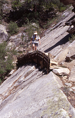 Laurie carefully navigates her way across Slick Rock. |
Unfortunately, due to miscommunications over the Motorola TalkAbouts, a couple of our hikers take this detour by mistake and are forced to backtrack a half-mile, since we are uncertain where the detour trail merges back with the main trail. The ravine we are now travelling starts to narrow down, and the trail takes us along several deep and inviting pools of clear, cold water in Ash Creek, where we see a number of small trout hanging suspended above the bottom of the pools, darting about nervously at the sight of our shadows. At Slick Rock, long metal grates pounded into the granite bedrock help keep the trail anchored into place. Shortly beyond here, we cross the creek once again and are treated to the sight of water cascading and sheeting down huge, steeply tilted slabs of granite, dropping about sixty feet into the creekbed below. It looks almost like an adrenaline pumped version of Slide Rock in Oak Creek Canyon, but only the very foolhardy or the totally suicidal would even think about sliding down this extremely treacherous and deadly rock slide. The real Ash Creek Falls is still a short distance down the trail, so we move on in search of the genuine article. |
|
Quickly closing in on our goal for the day, we begin to hear the subtle sounds of cascading water, before rounding a bend in the trail and actually catching our first glimpse of the falls at a rocky overlook point at trail’s edge. At slightly over 200 feet in height, Ash Creek Falls is the largest perennial waterfall in southern Arizona. In a picture postcard scene straight out of Arizona Highways Magazine, the waters of Ash Creek drop from a nearly vertical granite cliff face and cascade ever so slowly down the cliff – a naturally flowing creek bed following the relentless course of gravity, as it drops into sheer space and converts into a misty, smoky veil of water, seemingly dropping in slow motion, as it makes its way down to a pool of water far below at the base of the cliff and continues on its course as lower Ash Creek. |
|
The view around the falls to the north includes an immense forest filled canyon, long stretches of the Mogollon Rim, parts of the White Mountains, and Safford and the Gila River Valley 5,000 feet below us. One has to work to see this entire falls in its full glory and splendor, since the rocky outcropping blocks the lower part of the falls from view. For the very best unobstructed view of Ash Creek Falls, you really need to make your way down a sloping hill of fairly loose rock and gravel and then move out onto a narrow ledge on the right side of the outcropping – a tricky and bit risky maneuver, but well worth the effort, if you want the best view and a good picture. Use your own judgement here, but be extremely careful and make wise use of all the available handholds on the way down. Actually, tying a rope to a tree at the edge of the trail and using that as a safety harness on your way down would be an even wiser approach. All of our cameras are working overtime here in an almost futile attempt to capture the essence and beauty of this little spot of paradise, this place of Eden, in Arizona. |
 Ash Creek Falls at long last. |
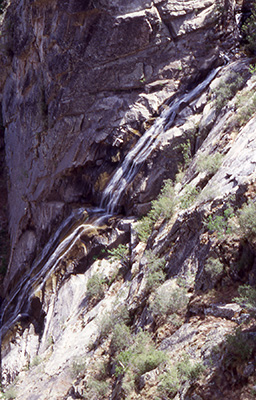 Close-up of Ash Creek Falls. |
Like the Grand Canyon, or any other grand vista, you really have to come and see it for yourself to get the full three dimensional perspective, to gain a keener appreciation and understanding of what it is all about. Our taskmaster, Laurie, reminds us of the time once again and the need to start back up the trail, and it is only with great reluctance and continued prodding that we are forced to leave all of this behind us, and start the long uphill trek back to the trailhead. This is definitely worth checking out on another trip, at another time, when we can plan on spending a lot more time enjoying this area and perhaps even dropping a fishing line or two into the cool, inviting waters of Ash Creek, in search of those elusive and sly Apache trout. We start back up the trail, casting one last backward glance at the falls and surrounding scenery, and leave another Arizona Eden behind us – but only temporarily, for we will all return again one day. Back at the Slick Rock area we finally meet Joe, Dave, and Yu-Ling coming down the trail. |
|
Apparently, Dave talked Joe into changing his mind about heading back early, and it sounds like Joe is glad that he did. Dave, the consummate trout fisherman, is really wishing that he had brought his fishing gear along on this hike, after spotting the trout hanging out in the deeper pools of Ash Creek. We tell them about the falls and being extra careful around the rocky outcropping and then part company one last time, wishing them a good hike and a safe trip back home. We make the 2.5- mile hike back to the trailhead in record time, despite the 1,400-foot elevation gain, and arrive back at the top by 12:15 in the afternoon. We are surprised once again that we see no one else, outside of our own small group, the entire time we are on this trail today. For one of the most scenic trails on one of the most beautiful mountains in Arizona, it is almost unbelievable that we do not see other hikers enjoying the trail with us today. On some other hikes, we should be so lucky. After resting and washing up (surprisingly, this campground actually has running water), we head back down the road to our home at Cunningham for the past couple of days, where we are greeted by Rochelle, who has grown concerned over our late arrival. I had underestimated our total time on the hike, and we were about forty-five minutes over schedule, but she forgave us anyway, although there was no offering of Krispy Kreme donuts this time. In our absence, she had packed away their tent and camping gear, and she and Richard were now ready to hit the road and head back to the valley. We bid them a fond farewell and begin the task of taking down our own tents and attempting to pack (stuff and cram are actually more accurate words to describe this process) all of our collective gear back into Laurie’s 4-Runner. That monumental task finally completed, Laurie, Beth, and I start our own journey back down the long and winding road (sounds almost like the title of a classic Beetles song, doesn’t it?) known as the Swift Trail, as we leave Mt. Graham and the Pinalenos behind, and prepare to go back to the real world and the civilization that awaits us there. Then again, perhaps we are actually leaving the real world behind us right here on this magical and breathtaking sky island known as the Pinalenos, and we don’t even realize it. |
 Top of Page
Arizona Trailblazers Hiking Club, Phoenix, Arizona
Comments? Send them to the AZHC .
updated January 3, 2018