Outdoor Links
Hike Arizona
Trip Planning Guide
Trip Report Index
Calendar of Events
Library
|
Woodchute Trail Day Hike, Jerome Hiking the Mingus Mountain Wilderness June 9, 2001 by Chuck Parsons |
|
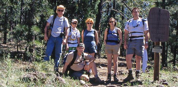 Chuck, Angie, J.C., Mary, Staci, and Mike at the Woodchute Trailhead. |
|
On this bright and sunny late spring morning in June, six Motorola Hiking Club members were tooling along on U.S. 89A in the Mingus Mountains, on what turned out to be a futile search for the Yeager Canyon Loop trailhead. High up in the Mingus Mountains, not far from Jerome, Mike Wargel, Staci Sontag, J.C.Pinney, Mary Singleton, Angela Lien, and Chuck Parsons were searching for the elusive trailhead to this six-mile loop hike, when we pulled into a parking area to evaluate our options. It was already 9:30 in the morning and surprisingly warm, despite out 7,000-foot elevation. I simply did not have sufficiently clear information on exactly where our trailhead was and have to apologize to everyone on this hike for that shortcoming. Luckily, Staci and Mary came to the rescue for us and helped save the day by recommended the nearby Woodchute Trail. It seems they had both hiked this trail in the past year or two and said it was quite scenic, as well as not being very difficult or very long. That sounded like a good plan to the rest of us, so we proceeded a short distance down 89A to the Potato Patch Campground turnoff, just east of Mingus Mountain Pass, and drove to the trailhead parking area. By 9:45 AM we were geared up and ready to start hiking, although we would have a little over half a mile of forest road to hike before we would even reach the actual trailhead. The temperature stood at a toasty 85 degrees already, and our journey had only just begun. Counting the forest road, we were looking at close to a four-mile hike, with about 800 feet of elevation gain, to the top of Woodchute Mountain. We didn’t waste any time traversing the relatively easy forest road through a mixed conifer forest of ponderosa and pinyon pine and alligator juniper, with its telltale rough, fissured bark resembling the back of an alligator. |
|
There is an interesting story behind the naming of Woodchute Mountain. The original forest of ponderosa pine was clear cut off the top of this mountain back in the late 1890s to provide shoring timbers for the expanding copper mines of Jerome on the north side of the mountain, as well as lumber for the growing town itself. The challenge was transporting these enormous ponderosa logs down the mountain to the mine sites. |
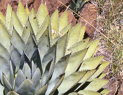 The perfect agave. |
|
The loggers came up with a solution by building a giant wooden trough, or chute, all the way down the north side of the mountain. With a constant flow of water running down the chute, logs were loaded in at the top and literally floated down the mountainside to loading platforms at the base of the mountain, where they were then transferred onto narrow gauge rail platform cars for the short trip into Jerome. Upon reaching the trailhead sign, we paused for a short break and group photo opportunity before proceeding. As we were hiking, Mary mentioned that her group had seen signs of bear in the form of paw prints and droppings on their hike a couple of years ago on this trail. About thirty minutes into the trail, we came across a couple of hikers who said they had spotted three black bears just last weekend at Woodchute Tank. Not too much further along we met a returning hiker, who warned us that he had spotted a rattlesnake just off the trail, not too far ahead of us. I radioed ahead to Staci, who was now our point lead, to be on the lookout for both snakes and bear. We have seen rattlesnakes on several of our previous hikes, but have yet to spot the elusive bruin, who will usually go out of their way to avoid human encounters. This brings to mind an interesting bear story that has since become legendary, as it is retold countless times in bear country. It seems there is a very easy way to tell the difference between grizzly and black bear droppings on the trail, very useful knowledge when traveling in grizzly country. |
|
A lot of hikers believe that a good deterrent to grizzlies in particular is the use of bear bells (large jingle bells) and pepper spray. The idea of the bells is simply to make noise and warn the bears of your presence, while the pepper spray would be the last defense in the event of an actual encounter. Since both species eat much the same thing, and their droppings look very similar, a dead giveaway to grizzly droppings is the presence of bells and the distinct odor of pepper spray. Of course, in Arizona we don’t have to worry about grizzlies, since they have been extinct from this state since the late 1930s, when the last one was shot high atop Mt. Graham. Our trail now follows an open ridgeline on the mountain’s southern exposure, and speaking of exposure, we are now in full sun most of the time, with only occasional patches of shade from our thinning forest canopy. However, as we slowly gain elevation, we are compensated with increasingly panoramic views on both sides of the trail. |
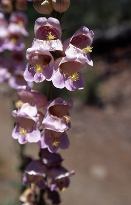 Lavender foxgloves are in full bloom. |
|
On our right (east) are the Black Hills, Lonesome Valley, and numerous ranges extending as far as the eye can see. To our left (west) are the Juniper Mountains and Chino Valley. Higher up on this ridgeline, we see the Verde Valley and the red rock country around Oak Creek Canyon. The views along this stretch of the trail are absolutely stunning and are complemented by blooming lavender foxglove waving in the breeze, Indian paintbrush, wild mountain rose, and prickly pear cactus. |
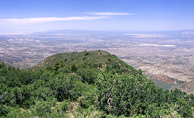 Verde Valley and the red rocks of Sedona from Woodchute Mountain |
Our gently rising scenic trail along the ridgeline soon gives way to a more rocky and less gentle ascent to the top of Woodchute Mountain. Staci, Mike, and Angie are still in the lead about five minutes ahead of me, with Mary and J.C. a couple of minutes to the rear. We are all keeping in touch with our trusty Motorola TalkAbouts. |
|
I ask Staci from time to time about bear and snake sightings, and the only signs of wildlife she has seen so far is one striped lizard at trail’s edge. Not long after that, I spot a fat horned lizard scurrying off on the right side of the trail, no doubt disturbed by our approaching footsteps. It is getting increasingly warmer along this stretch of the trail, as we struggle to make our way up what is becoming a steeper and rougher ascent to the top of this mountain. Mary keeps telling us it will level out soon, but we sure don’t see any sign of it right now. Finally, after another fifteen minutes or so, I see signs of the trail starting to top out. |
 This century plant sends its mammoth bloom stalk skyward. |
I am now walking alone along this stretch of the trail, as it begins to narrow down with dense brush on either side, when I hear a rustling movement through the brush to my left. Thinking it is probably a ground squirrel or field mouse, I pause for a second to see if I can spot anything. Then I freeze in my tracks, as I hear that unmistakable and heart-stopping buzzing/rattling sound of a rattlesnake! Where is it? Am I within striking distance? Looking down a little lower to my left, there he is – in the shade of a leafy and low-hanging branch of scrub oak-coiled up, tail buzzing, and ready for action. From its dark greenish-brown color pattern, with diamond-shaped areas bordered in white, it appears to be a small Mohave rattler. This is the most deadly and venomous of all of Arizona’s rattlesnakes, and this is one guy you don’t want to mess around with, so we give him a wide berth as we move by and warn the others ahead. If he wants this part of the trail, he can have it. We won’t argue at all. |
|
With that close encounter out of the way, we are soon relieved to be on level ground once again. We had just completed most of our 800-foot climb to the mountaintop, not really that much gain, except for the fact most of it was over a relatively short distance. After about another mile of easy hiking through the forest, Mike radioed back that he had left a small white towel as a marker at a fork in the trail. We soon discovered the towel and made a right turn out to the rim overlook, where we hoped to have lunch while enjoying the great views. Reuniting with Mike, Staci, and Angie, we were informed that the overlook was great, but the swarms of biting gnats were a real nuisance. Taking a few pictures, we move on to what Staci and Mary are sure was The Overlook, where they had enjoyed lunch and an even better view a year or two earlier. However, this was not quite what they had in mind after all, so we move on once again. Backtracking a bit, we go through a couple of cattle gates and follow a fence line to what Staci and Mary are now certain is The Overlook. We wonder around this area for awhile (getting hungrier all the time), before they finally come to the conclusion that, alas, this is still not The Overlook they had in mind. We backtrack once again (say, just who is leading this hike anyway?) and finally make a group decision to park ourselves on an outcropping of large basalt rocks and start chowing down, even though this is not The Overlook, and we don’t have quite the view we would enjoy from the rim. |
|
The time is 12:15 PM. While enjoying our lunches from our 7,800-foot perch high atop Woodchute Mountain, we admire the spectacular surrounding views of the red rock country to the west of Sedona, the Sycamore Canyon Wilderness area, and even the San Francisco Peaks and Mogollon Rim off in the distant haze. |
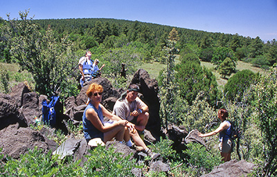 Hikers break for lunch on top of Woodchute Mountain. |
|
We also enjoy and greatly appreciate a cooling breeze blowing up from below the rim, as we catch sight of two sailplanes cutting tight circles, while rising higher and higher on a thermal air mass boiling up from the valley floor far below. As they circle, we lose sight for a while and then catch the bright reflection of sunlight off their wing surfaces. What a memorable sight, as we finish up and make preparations for our return trip. |
 Top of Page
Arizona Trailblazers Hiking Club, Phoenix, Arizona
Comments? Send them to the AZHC .
updated September 21, 2018