Outdoor Links
Hike Arizona
Trip Planning Guide
Trip Report Index
Calendar of Events
Library
|
Lost Ranch Ruins Day Hike Phoenix South Mountain January 1, 2015 by Becky Johnson |
|
 Scott, Bill, Ted, Eileen, and Michael stand before the mighty Sierra Estrella. [photo by Becky] |
 Eileen knows the way from here. [photo by Ted] |
Today we hike in the southwest area of South Mountain Preserve which has been referred to as the world’s largest municipal park. Close to 17,000 acres and founded in 1924, it was first named Phoenix Mountain Park. The trails are at the base of the Gila Range within the Preserve. We begin our hike at the Pyramid Trailhead at the end of Chandler Blvd. It is a nippy 36 degrees outside but we warm up, setting a good pace eastward. Taking a connector trail we continue along a wash up to the mine shafts which are filled in. Ore was mined |
 Mine your own mine! [photo by Ted] |
 Ted, Bill, Scott, Becky, Eileen, Michael. [by Bill] |
 Trailblazers on the march: Eileen, Bill, Scott. [photo by Becky] |
 Trailblazers on the march: Scott, Bill, Eileen, Becky. [photo by Ted] |

|

|
| I once saw a bird on a bough ... [photos by Ted] | |
 Tree grows bravely out of the rock. [photo by Ted] |
 Quartz displays a delicate pattern. [photo by Ted] |
 Becky explains the natural history. [photo by Ted] |
|
On the trail near the old mines are several healthy Bursera Trees, also known as Elephant Tree. This species grow in the Sonoran Deserts of Arizona, California and Mexico. Birds such as the Gray Vireo and Ash-throated Flycatcher feed on the red berries. The sap from the tree has medicinal purposes. Its thick trunk stores water. We found that the shaggy, peeling bark smells like camphor. Today we encounter an Ash-throated Flycatcher guarding the berries of the Bursera Tree. |
 Rock Daisy Wash. [photo by Becky] |
 No Burn Day. [photo by Becky] |
 Bill finds the perfect chair. [photo by Michael] |
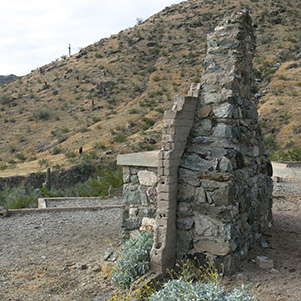 If only fireplaces could talk. [photo by Ted] |
 Lost Ranch Ruins [photo by Bill] |
|
Phoenix South Mountain Preserve Rangers refer to this as the Lost Ranch. It was approximately 2,000 square foot structure in its time, possibly a speak-easy for the miners. It was accessible by horse or horse and buggy. It pre-dates 1920. See Report. When the sun comes out for a brief time, the beauty of the trail appears in the colors of the grasses, Brittlebush and brown and tan veneer of the desert varnish on the rocks. |
 Climbing the Bursera Trail. [photo by Becky] |
 Looks like a long way up. [photo by Bill] |
 Double-barreled barrel cactus. [photo by Bill] |
 Up the Gila Trail. [photo by Bill] |
 Bursera, or Elephant Tree. [photo by Becky] |
 Lichen & Moss. [photo by Becky] |
 Looking east toward Mt Suppoa and the TV antennas. [photo by Bill] |
 Looking west toward 51st Avenue and community of Komatke on the Gila Indian Reservation. [photo by Bill] |
 View of the Desert Foothills on the down grade. [photo by Becky] |
|
We now turn east, returning on the Bursera Trail which is a 2.4 mile ridge trail descending back to the desert floor. At its highest point, the elevation is 1,956 elevation. It is 40 degrees and about 11 AM. The temperature on our hike rarely exceeded 46 degrees. Throughout the day we could see the Estrella Mountains dusted with snow. |
 Cloud-topped Sierra Estrella, from the Bursera Trail. [photo by Ted] |
 Montezuma Sleeping. [photo by Ted] |
 Peak 4512. [photo by Ted] |
 Lost Ranch Ruins, from the Bursera Trail. [photo by Ted] |
 Butterfly Mountain. [photo by Ted] |
 Montezuma Peak. [photo by Ted] |
|||||||||||

|
|
||||||||||
 Top of Page
Arizona Trailblazers Hiking Club, Phoenix, Arizona
Comments? Send them to the AZHC .
updated November 19, 2019