
Outdoor Links
Hike Arizona
Trip Planning Guide
Trip Report Index
Calendar of Events
Library
|
Cibola Pass Loop Day Hike Sedona April 11, 2015 by Ted Tenny |
|
 Trailblazers ready to start from Jim Thompson Trailhead. Fin in the background. [photo by Dave] |
|
Front Row: Ranka, Diana, Jazmin, K.G., Rudy, Lin, Beatrix, Jan Second Row: Biljana, Linda, Emma, Monika, Wendy, Jim, Grace, Debbie, Carmen, Phil, Mary Lou, Ted Third Row: Steve, Susan, Antonio, Glenn, Sharon, Dave |
|
Setting a new record for hikes led by me, 26 terrific Trailblazers and Stanford alumni set out from Jim Thompson Trailhead on a gorgeous spring morning. The trailhead is named after a local pioneer. Jim Thompson, 1841-1917, was born in Ireland. He came to the United States and eventually to Arizona, where he married Maggie James in 1880 and lived at his Indian Gardens ranch in Oak Creek Canyon. There’s a Jim Thompson exhibit, and much more, at the nearby Sedona Heritage Museum. We start on the Brins Mesa Trail, which winds through the forest on its way to a stone stairway which begins our big climb up the mesa. On our way, the Fin is helpful because we can gauge our progress by its changing appearance. When we see it edge on we are halfway to the stairs, and when we see its north side we’re almost there. |
 Chess pieces atop the ridge to the east. |
 Hikers find a scenic overlook on the Brins Mesa Trail. [photo by Dave] |
 Wilson Mountain Barrelhouse. |
 Scowley stone face overlooks the trail. |
 A little house on a hill, Sedona style. |
|
Amazing rock formations cheer us on the way up. We keep a sharp eye out for the Wilson Mountain barrelhouse on the right, and a little house on the hill on the left. Admittedly the house is a natural rock formation. But what a view! |
 Whew! We made the climb up to Brins Mesa. |
 Methinks Lost Wilson Mountain has been found, behind this unnamed mesa. |
 Let’s all wait for Ted here at the trail junction. |
 Delicate layered formation at Soldier Pass. |
|
Brins Mesa is the high point of our hike. The Brins fire in 2006 cleared much of the vegetation, but it’s growing back. A gradual descent takes us into the woods and the junction with the Soldier Pass Trail. Soldier Pass is mild-mannered at the top, but then the trail gets steep. Fortunately the steep parts are over bare rock. Some of the caves on the east side turn out to be arches, open at the top. We’re there at the right time of day to see sunlight inside a prominent arch. |
 Coxcomb dominates the western skyline of Soldier Pass. |
 It’s really an arch. You can see the sun shining inside. |
 What’s this? A butte with gears? |
 One of the Seven Pools. |
|
The trail reaches a Jeep road, then meanders along the east side of Soldier Wash on the way to the Seven Pools. There’s probably a place where you can take a picture of all seven of them, but I settled for one this time. From there it’s a short walk to the Devil’s Kitchen. |
 Onward, to the Devil’s Kitchen! |
 Snap! But don’t get too close to the edge. |
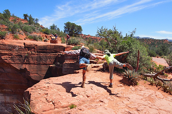 We can fly! We can fly! [photo by Steve] |
 Let’s take a flying leap! [photo by Wendy] |
| → More pictures of this hike, by Wendy Rennert. |
 The Sphinx. |
|
The Devil’s Kitchen is a sinkhole where minerals have dissolved and left a huge depression. Trees grow at the bottom and great boulders have fallen in. The Trailblazers are careful to stay back from the edge as they snap pictures and admire this natural wonder. Rock surfaces are black with tire marks as daredevil drivers haul tourists in their Jeeps. We start walking east on the Jordan Trail. “Both the Jordan Trail and the Cibola Trail will get you there,” I advise them, “But the Jordan Trail is twice as long, and the Cibola Trail has better scenery.” We continue eastward for Cibola Pass. |
 Steamboat Rock indicates that we’re on the home stretch. |
|
In 1540, Francisco Vásquez de Coronado led a thousand mile expedition from New Spain to seek the legendary Seven Cities of Cibola. Coronado was never here, but we walked up and over Cibola Pass and on down to the Jim Thompson Trailhead, where our hike ended. Thanks to everyone who went with me on this hike! A leader couldn’t wish for finer companions on the trail. |
| This hike is described in Footloose from Phoenix, by Ted Tenny, pages 251-257. |
|

|
||||||||||||||||||||||||||||||||||||||||||||||||
 Top of Page
Arizona Trailblazers Hiking Club, Phoenix, Arizona
Comments? Send them to the AZHC .
updated September 23, 2018