Outdoor Links
Hike Arizona
Trip Planning Guide
Trip Report Index
Calendar of Events
Library
|
Verde River Trail Day Hike Sheep Crossing Bridge, Yavapai County December 6, 2014 by Dave French |
|
 Dave, Kim, Cathy, Michael, John |
|
On a very cool, cloudy Saturday morning, five hearty hikers meet at 7 AM at a shopping center on Pima Road in Scottsdale. We realized we could all fit in Michael’s big white pickup, so we were delighted to limit the driving to a single vehicle. The drive to the Verde River Trail is about 60 miles from the meeting place, 35 miles of that are not paved. The last 12 on FR 269 are a little rough, but passable. The pickup is equipped with 4-wheel drive but we never had to use it. We did cross some steam beds with water flowing but nothing to worry about. The roadbed is mostly rock so we did not encounter mud despite the almost inch of rain that fell on Thursday. We are most grateful to Michael for agreeing to drive and doing a great job of it. |
 Climbing out of first wash crossing. We were not able to get much information about the bridge except the current bridge was built by the National Forest Service to replace a bridge that was built by sheep herders. They pastured their sheep in the high country during the summer and then drove them down to the desert for the winter. The Verde River posed a major problem by washing away many sheep as they tried to cross. The herders then built the bridge and herded huge flocks across. See the explanation on a sign mounted near the east end of the bridge. The Tonto NF website has the following information: “On the banks high above the river stands a replica of the Verde River Sheep Bridge. The Flagstaff Sheep Company and the Howard Sheep Company constructed the original bridge to minimize the loss of sheep when crossing the river. The bridge was started in 1943 and finished in 1944 at a cost of $7,277. The material used came from an Arizona mine and from a railroad line. On November 21, 1978, Sheep Bridge was entered into the National Register of Historic places. Sheep Bridge is the gateway to the west side of the Mazatzal Wilderness.” |
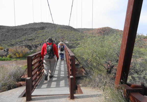
 Starting the hike crossing the bridge. |
 View of river from bridge. |
 East end anchor for suspension bridge. |
 Red cliffs along the river valley. |
 Plaque at east end of bridge. |
 Fall color. |
 Wet stream crossing. |
 View of bridge from the trail. |
|
I do not know the length of the current bridge but it is a steel suspension bridge providing a walkway about 3 feet wide. Much too narrow to carry the flocks of sheep of yesterday. The cables that hold up the bridge are anchored in rock at the east end and in a concrete “dead man” at the west end. |
 Trekking through high desert. |
 Verde River from the trail. |
 Entering wilderness after about a mile. |
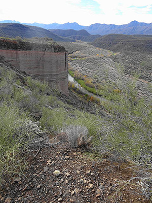 Cliffs, looking south from the top. With one step, whap, he was down. The second hiker did the same thing. So the two of us had brown rear ends the rest of the day. The other three hikers learned from our mistakes and made it across the steam without mishap. We climbed up the north side of the wash and headed across beautiful high desert with lots of saguaros, palo verde and several types of cholla. To our left the tree lined Verde River provided a magnificent contrast and the mountains and cliffs of the Verde Valley brought it all together. |
 The White Cliffs. |
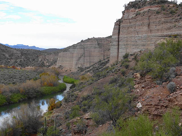 Cliffs up closer. |
 Verde River viewed from top of cliffs. |
|
We hiked northward for just over three miles and reached the top of the hill above the white cliffs (see GPS map). The white cliffs were formed by a volcanic layer over sandstone. The river eroded the sandstone leaving sheer cliffs separated by an area that appears to have had a major landslide. At this beautiful view point we stopped to eat our lunches and rest a bit. Unfortunately there were no rocks to sit on and this old trip leader does not sit comfortably on the ground. As a result, we did not stay too long and headed back south along the trail. The trail continues northward for another 5 miles are so, according to the signs. |
 Cliffs looking northwest from the top. |
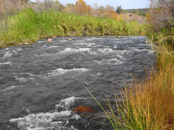 Raging River. |
 Cliffs viewed from the river. |
|
Once we got off the white cliff hill, we decided to depart from the trail and followed a wash toward the river. We ended up crossing the trail but continued down the wash to the river where it had some pretty good rapids. We decided to travel downstream in the high-flow channel of the river for a ways. We encountered a dense thicket of reeds and trees and decided to head for higher ground and find the trail again. With a little searching and help from our GPS, we got back on trail and returned to the trailhead. The distance traveled was 6.5 miles and the gross elevation change was about 450 feet. |
 No sound because no one there to hear it? |
 4-inch tarantula. |
 Crawl hole in the reeds. |
 River valley, looking south. |
 Crossing the stream. |
|
After getting our packs off and having a well-deserved beer, we decided to try to find the “hot springs” that Eileen had alerted me to. I understood the spring was to the north and not very far, so we drove to the north end of a large unpaved parking area and found a rough jeep trail leading down to river level. |
 “Hot Tub” Sure enough we found the rock lined “hot tub” with a pipe supplying water controlled by a float valve. The water was warm but not hot. For those that camp in the area, it must be a welcome asset to be able to take a bath (hopefully without using soap). I proceeded back through the tunnel the way we came in. Clever Michael decided to go out the other end, did not have to crawl, and found that it lead to a trail that takes you to the west end of the bridge where we had parked for the hike. For future reference, look for the trail near the west end of the bridge to lead you to the “hot spring”. |
 Heading back across the bridge. |
 View of the bridge from river level. |
|
We all piled into Michael’s truck and endured the 2.5 hour drive back to the meeting place on Pima Road. We arrived about 5:20 PM. Due to evening engagements, we did not stop as a group for drinks and food. |
 Top of Page
Arizona Trailblazers Hiking Club, Phoenix, Arizona
Comments? Send them to the AZHC .
updated June 27, 2019