Outdoor Links
Hike Arizona
Trip Planning Guide
Trip Report Index
Calendar of Events
Library
|
Sabino Canyon Day Hike Tucson November 29, 2014 by Chuck Parsons |
|
 Trailblazers gather at the Sabino Canyon Visitor Center. [photo by John] |
|
The time is 9:30 AM on a beautiful late November Chamber of Commerce morning in Tucson, as ten Arizona Trailblazers board the Sabino Canyon Shuttle for the 3.8 mile ride through the canyon to the Sabino Canyon Trailhead. The temperature is a very pleasant 72 degrees. Our destination on today’s hike is Hutch’s Pool, 4.1 miles from the trailhead. Oddly enough, despite a fairly easy hike and terrific scenery along the trail, we haven’t done this hike since November, 1997, 17 years ago almost to the day. Hopefully we won’t wait another 17 years to do it again. |
 Sabino Canyon. |
 Pusch Ridge Wilderness. |
 All aboard! [photos by John] |
|
The park shuttle pulls out, and we begin our narrated ride through the canyon. About a half-mile down the road we are in complete shade, and it feels like the temperature has suddenly dropped about 20 degrees. Little wonder, since nighttime temperatures have been dropping into the low to mid-40s and it’s been nearly 17 hours since sunlight last penetrated this canyon. Those of us who left our long-sleeved shirts and light jackets in our vehicles are now beginning to regret that decision and hoping we will be back out in the sun very soon. But the longest stretch of this drive is in the deep cold shade of Sabino Canyon, a good thing on a warmer day, but not at this time of year. And the breeze in the open-air shuttle is certainly not helping either. B’rrr! |
 Reflection Pool along Sabino Creek. [photo by John] |
 Giant saguaros reach for the sky. [photo by John] |
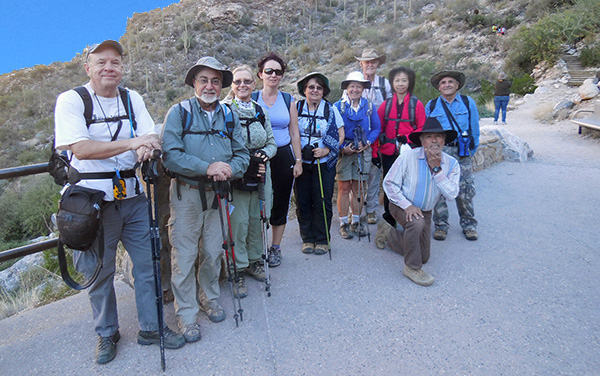 Ten Arizona Trailblazers gather at the Sabino Canyon Trailhead. [photo by John] |
| Left to right: Chuck, John, Dottie, Biljana, Monika, Linda, Dave, Funyung, Rudy, Arturo. |
 Next Stop: West Fork Trail junction. [photo by John] After twenty minutes of travel time on the scenic canyon drive we reach the Sabino Canyon Trailhead, gather all our gear together, and pose for a quick group picture. Starting at 3,330 feet, the Sabino Canyon Trail begins climbing right away through a tight series of short steep switchbacks for a long 0.8 miles before finally leveling off on a high ridge along the east side of Sabino Canyon and Sabino Creek. There doesn’t appear to be very much water flowing in the creek today, but we can see occasional pools of water shimmering in the early morning light on the canyon floor. |
 Ready to hit the trail. [photo by John] |
 Climbing through switchbacks. [photo by John] |
|
Among the numerous drainages and canyons along the Santa Catalina Mountain’s front range, Sabino Canyon is the most popular of them all and can attract hundreds of visitors and hikers per day in warmer weather, many headed for a cool, refreshing dip in Hutch’s Pool. The sheer size of the Sabino Canyon Visitor Center parking lot is a pretty good indicator of just how popular this area is. If you don’t arrive here by at least 9:00 AM or so, you may not find a single parking space on a busy Saturday or Sunday morning. |
 Arizona Trailblazers are on the move. [photo by Chuck] |
 Fall colors in Sabino Canyon. [photo by Chuck] |
 The scenery just keeps getting better. [photo by Dave] |
|
At the junction with the Phoneline Trail, a half-mile from the trailhead, we make a left turn (since no one is interested in making a phone call) and continue upstream along the canyon’s east side. Climbing through another series of short switchbacks, we eventually level off on a ridgeline that offers great views deep into Sabino Canyon. The trail dips and climbs from time to time, but remains relatively level and rocky for the next two miles. |
 Linda, Dottie, and Arturo pause for a moment. [photo by Chuck] |
 Taking a short break along the trail. [photo by Dave] |
 Chief radio operator Arturo. [photo by Funyung] |
 John takes a breather on the trail. [photo by Funyung] |
|
The entire Sabino Canyon Trail lies within the 57,000 acre Pusch Ridge Wilderness, created by Congress in 1978 to protect and preserve a pristine and unspoiled wilderness of saguaro-covered slopes, hidden side canyons, and mountaintop forests in the heart of the spectacular Santa Catalina Mountains. |
 Trailblazers continue working their way through the switchbacks. [photo by Chuck] |
|
About 2.5 miles from the trailhead the trail makes a sharp curve to the right as it veers to the east, and we begin descending west from the ridge into Sabino Basin. The basin is a large open area and a lush drainage where several canyons converge. Mexican blue oaks, cottonwood trees, and Arizona sycamores flourish in this desert oasis. It also serves as a major crossroads for hikers enroute to the wild and rugged backcountry of the Santa Catalinas, including an aggressive 12-mile trek to the top of 9,157-foot Mount Lemmon. We’ll save that one for a later date. |
 The cottonwoods are beginning to show their fall colors. [photo by Dave] |
 Starting the descent into Sabino Basin. [photo by John] |
 West Fork / East Fork Trail junction. [photo by John] |
|
Just prior to reaching the basin we encounter a large group of about thirty hikers from a Tucson area school and stop to chat with them for a few minutes. At the next major trail junction we meet up with the rest of their group, as another twenty or so hikers file by us while we’re taking a break. This is the largest group of hikers we have ever encountered on any trail before and is yet another reminder of the popularity of this trail in the Santa Catalinas. After we reach the bottom of Sabino Basin and make our first dry stream crossing, we hit the junction with the East and West Fork trails. To the right the East Fork Trail eventually drops into Bear Canyon. A left turn onto the West Fork Trail leads to Hutch’s Pool, another 1.6 miles ahead in the basin. We decide to take a rest break here at the junction and wait for the rest of our group to arrive before proceeding on to Hutch’s Pool. |
 Trailblazers regroup for a break. [photo by Funyung] |
 Time to take five. [photo by Funyung] |
 Large logs and boulders provide the perfect rest stop. [photo by John] |
|
Once we finally have everyone together and rested, we head out across Sabino Basin in search of Hutch’s Pool, which will be our lunch stop and turnaround point. The basin is primarily grasslands with a mix of manzanita, agave, sotol, and Mexican blue oak. It also marks the boundary between the Lower and the Upper Sonoran life zones. While hiking across the basin one of our hikers notes the scarcity of giant saguaros in the area, and there’s a very good explanation for that. This is the upper limit for saguaros within the Lower Sonoran life zone, approximately 3,500 feet in elevation. They are virtually non-existent in the Upper Sonoran life zone, dominated by the grasslands we’re hiking in now. |
 Trekking through Sabino Basin. [photo by John] |
|
At 1.3 miles from the West Fork / East Fork Trailhead we come to our second stream crossing, this one with water in the form of small to medium-sized pools. We easily navigate the crossing on strategically placed steeping stones and boulders in the streambed. We continue hiking along the left bank of the stream as we make several more stream crossings and search for signs of Hutch’s Pool, making our way through tall stands of Arizona cypress, cottonwoods, and Arizona sycamores along the way. The trail to the pool is not too obvious, and after a couple of false starts Arturo goes down yet another path and finally locates the genuine article, 0.3 miles from the second crossing. Great navigation job, Arturo! |
 Closing in on Hutch’s Pool. [photo by Dave] |
 Dottie and Funyung make one of several creek crossings. [photo by John] |
 Close, but still not Hutch’s Pool. [photo by John] |
 The real Hutch’s Pool, at last. [photo by Funyung] |
 A second view of Hutch’s Pool. [photo by John] |
 One final view of Hutch’s Pool. [photo by Chuck] |
|
Hutch’s Pool is a very popular swimming hole in warmer weather, and at the peak of the summer season this area probably looks like a small version of New York’s Coney Island with hordes of swimmers and sunbathers. |
 A young boy is fascinated by Arturo’s radio. [photo by John] |
 Checking out Hutch’s Pool. [photo by John] |
 Boy is this water cold! [photo by John] |
Despite the frigid water on this late November day, two young children and their father can’t resist the temptation and decide to test the waters anyway, if only briefly. The expression on the young boy’s face, captured by John, says it all. Priceless! After checking out this picturesque area and taking a few pictures, we each seek out the perfect boulder and settle in at the far end of the pool for lunch and a chance to relax and enjoy the scenery before heading back. |
|
Throughout the 1940s a Tucson area English teacher would periodically take his students on horseback rides through the Santa Catalinas. Whenever he came across a prominent landmark for the first time, it was customary for him to name it after one of his students. On one such ride from Sabino Canyon to the top of Mount Lemmon the teacher and his students came across what he later described as “the most beautiful pool in the Catalinas.” One of his students on that ride was Roger Hutchinson, and he named the pool Hutch’s Pool in his honor. Seventy years later, the name still sticks. |
 The perfect lunch spot at Hutch’s Pool. [photo by Dave] |
 Smile for John’s camera! [photo by John] |
 Biljana enjoys a healthy salad. [photo by John] |
 Dave is a picture of contentment. [photo by John] |
|
Just as the last leg of the trail getting to Hutch’s Pool is none too obvious, the same scenario applies in returning from the pool back to the main trail. We suddenly find ourselves scrambling over large boulders alongside the streambed as we search for the main trail. Kind of reminds me of our recent trek through LaBarge Canyon in the Superstitions while in search of the Narrows. But instead of finding the Narrows, most of us find ourselves mired down in a minefield of huge boulders choking the streambed, some the size of SUVs and city buses. That hike set a new standard for boulder scrambling. |
 Boulder hopping back to the trail. [photo by John] |
 Just a few more boulders to hop. [photo by John] |
 We’re finally back on the main trail. [photo by John] |
 Rudy and Funyung in a duet version of Amazing Grace. [photo by John] |
 One final rest break before pushing on. [photo by John] |
|
After about ten minutes of some serious boulder hopping, Pathfinder Arturo comes to the rescue once again and locates an exit point that leads us back up to the main trail. We have a four-mile trek back to the trailhead, and we need to hustle to make it back before the last shuttle pick-up departs. We still have plenty of time though and don’t need to push it too hard. During one of our rest stops Rudy and Funyung perform a duet version of Amazing Grace, with Rudy on the harmonica and Funyung supplying the vocals. What an appropriate location to perform such a beautiful and touching song. |
 On the last leg back to the trailhead. [photo by Chuck] |
 The Thimble, one of the canyon’s most prominent landmarks. [photo by Chuck] |
 Back-lit Teddy-Bear cholla. Ouch! There’s nothing cuddly about this Teddy Bear. [photo by Chuck] |
|
We make very good time on the hike back out, but shortly after coming into view of the trailhead we hear the shuttle slowly rumbling its way up the canyon road. So we put it into high gear over the last quarter-mile of trail, while carefully navigating across the rocky terrain, and just barely make it back in time to board the 3:30 shuttle back to the Visitor Center. Fortunately though there are two more pick-ups after this one. But for hikers who miss the last 4:50 shuttle from this point, the only remaining option is to hoof it down the road for another 3.8 miles back to the Visitor Center. |
 Parting shot, with a half-moon rising over Sabino Canyon. [photo by John] |
 Our chariot awaits us back at the trailhead. [photo by John] |
|
The shuttle ride back to the trailhead is certainly more comfortable than the teeth-chattering ride through the shady canyon earlier this morning. At ride’s end we clean up and stow away our gear before talking to one of the local park rangers outside the Sabino Canyon Visitor Center. Among other things, we ask him for his recommendations for local restaurants. |
 Hungry Trailblazers pose in front of the Risky Business Restaurant & Bar. [photo by John] |
 Toasting another successful day of hiking. [photo by Dave] |
 Toasting another successful day of hiking. [photo by John] |
|
One of several on his short list is a nearby place called Risky Business, which is where we decide to cap off the day with good food and even better brew. A great finish to another successful day of hiking the amazing trails of Arizona. Great job, Arizona Trailblazers! |
 Top of Page
Arizona Trailblazers Hiking Club, Phoenix, Arizona
Comments? Send them to the AZHC .
updated September 12, 2016