Outdoor Links
Hike Arizona
Trip Planning Guide
Trip Report Index
Calendar of Events
Library
|
Dripping Spring Day Hike Superstition Wilderness January 18, 2014 by Chuck Parsons |
|
 Twenty terrific Trailblazers in the Superstition Wilderness. [photo by Bill] |
|
Front Row: Rudy, Nancy, Arturo, Gary, Edith, Quy, Bill, Lori, Darren. Back Row: Bruce, Betty, Andy, Chip, Mike, Linda, George, Gene, Dick, Michael, Chuck. |
|
On a beautiful sunny morning in mid-January, twenty eager Arizona Trailblazers gather at the junction of Dutchman’s Trail #104 and Coffee Flat Trail #108 for our requisite group picture. This hike was originally described as 11 miles round trip between the Peralta Trailhead and Dripping Spring. But based on new information received just days before the hike, I revised the hiking distance from 11 miles to 14 miles and expected only a handful of hikers to show up for such a long hike. But apparently there are a lot of hikers in this club who like the challenge of longer hikes. |
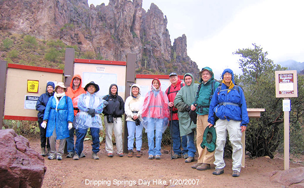 Dripping Spring group picture from January, 2007. [photo by Wayne] |
|
Flashback almost exactly seven years ago to January 20, 2007, when we last did this hike and you see 11 shivering Trailblazers decked out in rain gear and warm jackets under solid overcast skies with low-hanging clouds and mist almost obscuring many of the cliffs, bluffs, and hoodoos along the trail and making it feel more like a damp winter morning in the Pacific Northwest. On today’s hike we never see even the slightest wisp of a cloud in a sky of endless blue on a picture perfect Chamber of Commerce day. Only in Arizona. |
|
The time is precisely 8:15 AM on a bright Saturday morning in the Superstition Wilderness as twenty Arizona Trailblazers strike out from the Peralta Trailhead, bound for Dripping Spring. The temperature is a cool and comfortable 60 degrees on this brisk January morning, compared to a teeth-chattering 45 degrees on our 2007 hike. We begin a steady climb right out of the starting gate through a series of hills and rises as we head northeast on the Dutchman’s Trail along the northern edge of Barkley Basin and towards Miners Needle, the most prominent landmark in the distance. |
 A line of Trailblazers hikes through the Superstitions. [photo by Quy] |
|
Our first major milepost this morning will be the junction of the Dutchman’s Trail and Coffee Flat Trail, about 2.5 miles from the trailhead and just to the southeast of Miners Needle. After topping out at the saddle, the trail gradually begins switchbacking down to the basin floor as it continues to meander along the north boundary of Barkley Basin. Most of this vast basin lies within Tonto National Forest, but part of it is also within the privately held Quarter Circle U Ranch, once owned and managed in the 1920s and 1930s by its namesake William Augustus Barkley. As we finally near the junction the majestic Miners Needle, lying due south of Miners Summit, finally comes into full view. At 3,648 feet this major Superstition landmark marks the crossroads of two major trail systems tracking across this wilderness: the Dutchman’s Trail and the Coffee Flat Trail. Although the eye of the needle looks pretty small from our perspective on the trail, it’s actually large enough for a grown man to stand up in its center with room to spare, something we have witnessed on previous hikes as we watched rock climbers scrambling to the top of the needle. |
 Rocky monoliths stand guard over the trail. [photo by Quy] |
 A sea of cacti greets Superstition hikers. [photo by Quy] |
 Cathedral Rock, up close and personal. [photo by Chuck] |
 Miners Needle – upper right for eye of the needle. [photo by Chuck] |
 Miners Needle, one of the Superstitions’ most prominent landmarks. [photo by Quy] |
 Trailblazers gather at the junction. [photo by Quy] |
 Departing the junction on the Coffee Flat Trail. [photo by Bill] |
 Colorful lichen clings to the boulders. [photo by Quy] Exactly how the name originated remains a mystery, but as Ted Tenny is often fond of saying, “The Coffee Flat Trail contains no coffee beans, nor is it flat.” And that’s a fairly accurate description as we continue to wind our way up and down this rugged and rock-filled trail through numerous ravines and arroyos. Although we find no coffee or beans, there are certainly plenty of rocks and boulders to contend with. I have a sneaky suspicion that most of us will have tired and aching feet after hoofing it through 14 miles of this rough terrain. Break out the Epsom Salts, Ethel. My dogs are aching like crazy! |
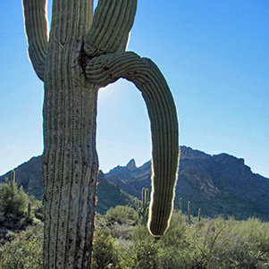
 Telltale signs of a raging desert wildfire. [photo by Quy] Even some of the taller saguaros like the one on the left side of this picture are dried and yellowed with spines burned and blackened. This desert giant has been completely charbroiled by the raging flames and will soon begin to crack and split open with its life juices slowly oozing and dripping onto the desert floor, bleeding it completely dry. It will take many years, even decades, for a new saguaro seedling to reach this size and stand guard once again over the Coffee Flat Trail. After doing a bit of checking after the hike I found out from one of the rangers at the Mesa Ranger District that this wildfire was caused by a careless camper in the area late last summer (September, 2013). But instead of the usual unattended campfire that’s responsible for the vast majority of these camper-caused wildfires, it seems that one of the campers got the bright idea of setting their used toilet paper on fire rather than burying it, along with their business, as any responsible camper would have. With the dry conditions present, a sudden gust of wind blew the burning toilet paper into some nearby dry brush which immediately ignited and quickly spread, torching about 25 acres of prime desert before finally being put down. The desert does not recover quickly, and the scars from one such careless act will be visible for decades. Amazingly enough, a nearby camper actually took the initiative to report this individual who has since been prosecuted and fined for their negligence. Unfortunately, there seems to be a growing trend in recent years for a very small minority of totally irresponsible, careless, and unthinking hikers and campers to leave human waste and toilet paper sitting on top of the ground instead of burying it a minimum of six inches deep which is the recommended and proper procedure. Unbelievably, on at least two occasions while hiking I’ve even seen this mess sitting right on the trail for anyone coming along to step in. At first glance, one might assume it’s from a dog or wild animal until you see the telltale wads of toilet paper mixed in. Personally, I don’t know of any other animals, other than the two-legged kind, who routinely use toilet paper. |
 Trailblazers moving out on the Coffee Flat Trail. [photo by Quy] |
 Reeds Water, a long-abandoned livestock watering area. [photo by Quy] |
 Saguaro Gargantuan in the Reeds Water area. [photo by Quy] |
We continue making good progress as we head east on the Coffee Flat Trail and eventually ascend through a short series of switchbacks up to the junction with the connector trail to the previously mentioned Quarter Circle U Ranch. This part of the Coffee Flat Trail once served as a freight wagon road between Mesa and Superior from the late 1890s through the early 1900s with hundreds of mule-drawn wagons, heavy with freight, making the difficult journey through this rugged and isolated landscape every year. In those days the Superstition Mountains were all about commerce and gold fever, with recreational hiking and backpacking unheard of and virtually nonexistent. We hike only briefly through the Whitlow Canyon area as it crosses the trail, passing by the U-shaped Coffee Flat Mountain to the north, before entering Randolph Canyon, north of Buzzards Roost. Coffee Flat Creek runs through part of the canyon, with a number of shallow pools alongside the trail. We hike in the deep shade of the canyon here where the warming rays of the morning sun have not yet penetrated, and the temperature plunges a good 15 degrees or more from the sun-filled parts of the trail. |
|
The tall mesquite, willows, and cottonwood trees provide even more shade along the creek bed. This is definitely the place to be on a hot summer day in the Superstitions, at least early in the day and hopefully with the creek still flowing. |
 Arturo poses in a natural picture frame. [photo by Quy] |
 Pools of water along the trail through Randolph Canyon. [photo by Quy] |
|
It’s somewhere in this area that we receive a garbled transmission over the TalkAbout radios from Bill and his group of seven who are about a quarter-mile or so ahead of the rest of us. Something about making a left turn at an upcoming wash or creek bed running across the trail. But due to the rugged terrain and the loss of necessary line-of-sight for the radios to operate properly, we lose all radio contact with his group for the next couple of hours. Unfortunately, Bill has the most accurate GPS track for the trail to Dripping Spring, while the rest of us only have paper maps to go by. So we keep on moving east through the canyon, with the use of maps, landmarks, and Michael’s partial GPS track to the spring. Despite our lack of communication, we hope to eventually meet up with Bill and his group at the spring where we will break for lunch. |
 Colorful Fairy Duster in full bloom. [photo by Quy] |
 Delicate blooms of the Shrubby Deervetch. [Quy] |
|
Despite repeated attempts to contact Bill and his party over our TalkAbout radios, we fail to establish any communications between the two groups of hikers. In the meantime we find ourselves drifting further off-course and believe we are actually in Whitlow Canyon at this point (later verified by Michael’s GPS map). It’s already 11:30 in the morning and unlikely that we will be able to retrace our steps and attempt to reach Bill and his party, who we assume are at Dripping Spring by now, with enough time left to return to the trailhead before darkness descends on these mountains. Since most of us are pretty tired and about ready to stop for lunch anyway, we decide to break for lunch right here in the creek bed where there are plenty of boulders for seating and large trees for shade. |
 Breaking for lunch in Whitlow Canyon. [photos by Quy] |

|
|
Although most of us won’t actually get to Dripping Spring today, it’s still been a spectacular day for hiking in the Superstitions with ideal weather, great company, and unbeatable scenery. And we are seeing a scenic part of Whitlow Canyon that none of us have ever seen before. |
 Seven Trailblazers pose by Dripping Spring. [photo by Bill] Bruce, Gary, Mike, Dick, Nancy, Edith, and Bushwhacker Bill. Bill describes it this way: “Dripping Spring is basically a muddy wall with a little vegetation growing around it.” So each group of Trailblazers is seeing something unique and different today.
|
 Trailblazers make the long trek back to Peralta Trailhead. [photo by Quy] |
 Saguaro Arm [photo by Bill] |
 Ouch! Careful there, George! [photo by Quy] |
| This giant saguaro is in bad need of arm surgery. Do we have an orthopedic surgeon in the group? | |
 Lori’s close encounter of the prickly and painful kind. [photo by Quy] |
|
After lunch we decide to hike north on an old jeep road that’s easier on the feet than the cobblestone-filled creek bed. We follow the road for a half-mile or so until it links up with the creek bed and then retrace our steps in the creek bed until we finally rejoin the Coffee Flat Trail and begin heading northwest toward Miner’s Needle and the junction with the Dutchman’s Trail. At some point along Coffee Flat Trail we finally hear back from Bill that he and his group are heading back as well. Less than an hour later Bill’s group joins the rest of us on the trail, and we all hike back together to the trailhead. We still have a long way to go, but at least we’re all safe and together once again. By 3:15 in the afternoon all twenty tired and foot-sore Trailblazers have limped back into the Peralta Trailhead, safe and sound, with all hikers present and accounted for. |
 Post-hike dinner at BJ’s Restaurant & Brewhouse in Mesa. [photo by Quy] |
|
Bill’s group has hiked a total of 14 miles today, while the rest of us did a little over 13 miles. After a bit of catching up and cleaning up, 11 hikers decide to call it a day and head for home, while the rest of us head for BJ’s Restaurant & Brewhouse near our meeting location this morning for a little camaraderie and R&R to cap off another great day of hiking the always amazing and adventurous trails of Arizona. And George is absolutely right: it really is all about the journey. |
 Andy enjoys his strawberry shortcake desert. “No, I am not sharing this with anyone!” [photo by Quy] |
 Top of Page
Arizona Trailblazers Hiking Club, Phoenix, Arizona
Comments? Send them to the AZHC .
updated August 3, 2017