Outdoor Links
Hike Arizona
Trip Planning Guide
Trip Report Index
Calendar of Events
Library
McDowell Preserve, Scottsdale
December 7, 2014
by Quy Nguyen
 Ten fantastic Trailblazers at Sunrise Trailhead. |
| Quy, Yanis, Monika, Kim, Sana, Gabrielle, Biljana, Jim, Lorraine, Ron |
|
The Andrew-Kinsey trail is named for Chet Andrews and Roy Kinsey, who created stewardship programs in their respective areas. This two mile trail was completed in May 2014 and it brought together two trail systems between the Scottsdale Sonoran Preserve and the Fountain Hills Preserve. There are four accesses from the Scottsdale side to the Andrews-Kinsey trailhead: 1. Sunrise Trailhead at 145th Street (2.2 miles from trailhead to Andrews-Kinsey trail)2. Lost Dog Wash (2.7 miles from trailhead to Andrews-Kinsey trail) 3. Sunrise Trailhead at 136th Street (2.3 miles from trailhead to Andrews-Kinsey trail) 4. Ringtail Trailhead at 128th Street (2.6 miles from trailhead to Andrews-Kinsey trail) I picked up the first option because of the mileage and spectacular views along this trail. The weather is pleasant with high of 76, sunny and breezy. |
 Balanced rock with the view towards northeast. |
 Saguaro and rocky spires with Four Peaks in the background. |
 Narrow canyon and the western mountain range. |
|
The trail is going up with some switchbacks. The trail is steep, rocky and loose gravel. It’s not too hard but a little challenge. We stop frequently to catch our breath, enjoy the surrounding view and take pictures. Along this popular trail we encounter some people going up and down. |
 Hikers enjoy the Viewpoint at 1.2 miles (2490'). |
 Hikers make their way up to the saddle. |
 Come on. It’s just a few more steps to the saddle. |
 Ron and Lorraine on the break. |
 “Sunshine on my shoulders makes me happy.” |
|
At the saddle, we stay straight 0.4 mile to the sign for the start of Andrews-Kinsey trail. |
 A-K Trailhead, at last! |
|
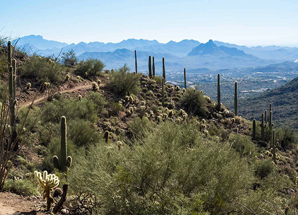
This trail is well-maintained, with spectacular views of mountain ranges, jagged rock outcrops, and beautiful Sonoran Desert flora such as saguaro, cholla cactus, ocotillo, and palo verde. From the intersection with Sunrise trail, this trail winds along the mountain. We can see the City of Fountain Hills with its fountain swirling. At 1.2 mikes we come up to a Scenic view at 2940 feet elevation to look towards the Phoenix Mountain range. At 1.6 miles the trail becomes narrow and makes a sharp turn into a narrow canyon. |
 The A-K trail has a view of Four Peaks with surrounding Sonoran Desert. |
 In the spring, the A-K trail will be gorgeous with wildflowers blooming. |
 Scenic View at 1.2 miles on the A-K trail. |
 View of mountain range with a stand of saguaros, from the A-K trail. |
 The A-K trail winds around the mountain with surrounding vistas. |
 The fountain in Fountain Hills. |
 Jagged rock cropping. |
 Narrow section looking down into a canyon. |
|
At the 2 miles mark the trail ends at the boundary of the Scottsdale McDowell Sonoran Preserve and the Fountain Hills Preserve. We stop at the sign to have lunch, then hike back the way we came. |
 Lunch at the boundary of Scottsdale and Fountain Hills. |
 Another nice spot for lunch. |
 “Here’s Sunrise peak. We are not going up there, are we?” |
 Hikers on their way down to Sunrise trailhead. |
 Flowers and fruit, even in the winter. |
 Where there’s quartz, there may be gold. |
 Sextuplets Barrel cactus. |
 Nice hairdo! |
|
This is a great hike, with fantastic views for those who live in the Phoenix area and don’t want to drive hours to get to the trailhead. Thanks to all for coming to join my hike. Happy Trails! |
||||||||||||||||||||||||||||||||||||||||||||||
|

|
|||||||||||||||||||||||||||||||||||||||||||||
 Top of Page
Arizona Trailblazers Hiking Club, Phoenix, Arizona
Comments? Send them to the AZHC .
updated May 30, 2020