
Outdoor Links
Hike Arizona
Trip Planning Guide
Trip Report Index
Calendar of Events
Library
|
Seven Springs Day Hike Tonto National Forest December 28, 2013 by Jim Buyens |
|
On the last Saturday of 2013 seven of us set out on a ten-mile tour of the Seven Springs Recreation Area in Tonto National Forest. The idea was to get some variety from the usual Valley trails without having to drive too far, and that we accomplished.
Our meeting point was the DC Ranch Crossing shopping center in north Scottsdale, a quarter mile from the northeast corner of the Loop 101 freeway. From there we took Pima Road and Seven Springs Road further northeast to the Cave Creek Trailhead. Parts of Seven Springs Road were gravel but easily passible.
 Edith, Linda, Anikó, Jim, Lance, Wayne, and Gary prepare to head out. [photo by Jim] |
Our plan was to follow the Cave Creek, Skunk Creek, Cottonwood, and Cave Creek (again) trails in a lollipop loop.
The Cave Creek Trail parallels its namesake creek and features a nice mix of leafy plants, trees, and shade. It’s a nice change from the usual desert landscape. Eventually, though, the trail reaches some canyon walls and rises higher. The terrain then returns to normal but the elevation provides some nice vistas.
 Stealthily we surmount a surprising fence crossing. Being near to the creek accounts for the leafy vegetation. [photo by Wayne] |
 You don’t often find shaded trails like this in the valley. Again, thank the creek. [photo by Wayne] |
 Here’s a shot that includes the creek itself. The creek runs all year but often underground. [photo by Lance] |
 As the early morning chills dissipate so does a layer of clothing. [photo by Jim] |
Our route involved four creek crossings, all with easy stepping stones. Finding the trail continuation was occasionally a bit difficult but somehow we managed to keep on track.
 This was the first of four times we crossed Cave Creek. [photo by Wayne] |
 Gary helps Anikó keep balance. [photo by Jim] |
 After the first mile or so the landscape reverts to normal Sonoran Desert. That’s not necessarily bad, though. [photo by Wayne] |
 This was our second crossing of Cave Creek. [photo by Wayne] |
 Here the creek widens to a pond. A small waterfall lets the water continue. [photo by Wayne] |
 Gary, Lance, and Linda survey the terrain. [photo by Jim] |
 With all the other scenery around, this spectacular crested saguaro is actually easy to miss. [photo by Wayne] |
 Here’s a close-up of the crest. Some scientists think it’s a genetic mutation, others the result of lightning strikes, and some to other disturbances of the growing tip. [photo by Jim] |
 Linda captures the landscape. [photo by Jim] |
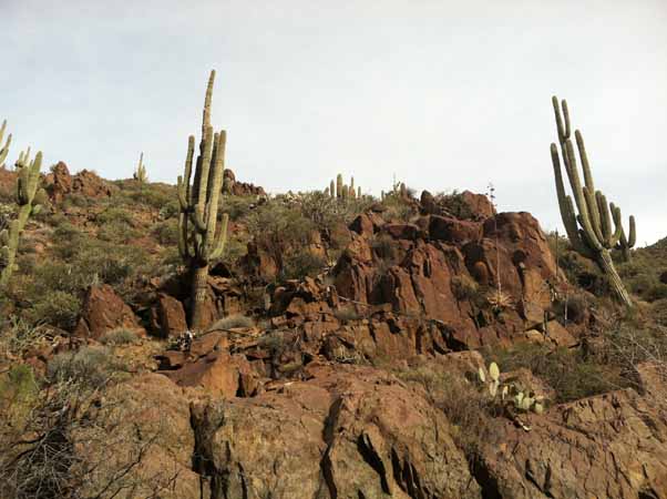 More Sonoran landscape. [photo by Lance] |
 This canyon was the last portion of the Cave Creek Trail we hiked. [photo by Wayne] |
 This was our third creek crossing. This one is hard to find because there aren’t any markers on the opposite side. [photo by Wayne] |
After the third crossing we switched from the Cave Creek Trail to the Skunk Mesa Trail. The next two and a half miles were all uphill, but not terribly steep in any one place. Still, this climb provided the best workout of the day. At the summit we rested over lunch and enjoyed the wide, expansive scenery.
 Oh, now there’s a sign, a few hundred yards from the creek crossing. We’re on the Skunk Mesa Trail now and the next two and a half miles are all uphill. [photo by Wayne] |
 Here I am about three quarters up the ascent to Skunk Mesa. Cave Creek flows in the crease below. [photo by Jim] |
 Gary finds himself ahead and pauses to check our position. [photo by Jim] |
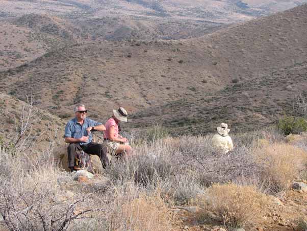 Lunch anyone? The scenery here at the top was fantastic but the seating was a bit hard and sparse. [photo by Jim] |
The trail back down was a little steeper and rockier than the one going up but not one person complained about all the altitude we were losing. When buildings and highways came into sight we knew we were close to the end.
Once down we took the Cottonwood trail back over Cave Creek (our fourth crossing) and then the Cave Creek Trail back to the trailhead. From there we headed back to DC Ranch Crossing and then either home or a bite to eat.
 These are the remnants of a bee hive. I suppose a bear reached in and cleaned it out. [photo by Jim] |
 To finish the hike we use the Cave Creek Trail back to the trailhead, and once again enjoyed the leafy vegetation and flowing waters. [photo by Lance] |
For late lunch / early dinner Edith, Linda, Anikó, Gary, and I stopped at a bistro in DC Ranch Crossing called Lushburger.
As you might suspect from the name, they offer a variety of upscale hamburgers. They also have a nice assortment of appetizers and side dishes. All the indoor seating is booths or barstools, though, and this prevents seating a large group all together. They also have outdoor seating though, and weather permitting, that seems to offer more flexibility.
All in all, this was a rewarding hike that I wouldn’t hesitate to take again. Thanks to everyone who came along! See you next time!
| Hike Statistics | |
| Starting time: | 9:19 AM |
| Ending Time: | 2:59 PM |
| Total Distance: | 10.5 miles |
| Moving Time: | 4 hours 17 minutes |
| Stopped Time: | 1 hours 23 minutes |
| Moving Average Speed: | 2.4 mph |
| Overall Average Speed: | 1.8 mph |
| Starting elevation: | 3374 feet |
| Maximum elevation: | 4108 feet |
| Total ascent: | 1931 feet |
| Starting temperature: | 42° |
| Ending temperature: | 63° |
 Top of Page
Arizona Trailblazers Hiking Club, Phoenix, Arizona
Comments? Send them to the AZHC .
updated December 31, 2019