
Outdoor Links
Hike Arizona
Trip Planning Guide
Trip Report Index
Calendar of Events
Library
Prescott
August 31, 2013
by Jim Buyens
|
Did you know that Barry Goldwater’s uncle had a lake named after him? Two lakes, in fact! Morris Goldwater, Barry’s uncle, was the mayor of Prescott between 1879 and 1927. During that time he continuously worked to provide the city with an adequate water supply. This led to a number of manmade lakes, including Watson, Willow, Lynx, Granite Basin, and two named after the mayor: the upper and lower Goldwater lakes. Hydraulically speaking, Water from Bannon Creek flows into Upper Goldwater Lake, then past a dam, then into Lower Goldwater Lake, and then if anything’s left, onward down the stream. Both lakes are small: the upper about 15 acres and the lower somewhat less. The upper lake is accessible from a very nice city park on Senator Highway, while the lower is privately owned. So what, you ask, does this have to do with hiking? Well, August 31 kept popping up on the Trailblazers calendar as an open date, and then I saw this hike scheduled on another club’s web site, and I figured hmmm, 10 miles out and back, only 1,000 feet elevation, wooded, cool temperatures, passes two lakes twice, why not? |
 Chuck, Wayne, Ed, and Jim at Goldwater Lake Park looking for the trail. [photo by Quy] |
 Passing out radios at the Watershed Trailhead. [photo by Wayne] |
|
Adding to the attraction, the Goldwater Lakes trail is part of the Prescott Circle Trail, a 50-mile loop planned to go around the city. And named trails like that usually have good maintenance. According to all the trip reports I found, the trail was very pleasant and well-marked. Given all that, I decided to make make it a, "Go," and six other Trailblazers signed up to join me. We were off! The only catch was finding the trailhead. While there is a Goldwater Lakes Trailhead, south of Prescott on Senator Highway, it’s more of an unnamed widening of the shoulder than a parking lot. Some distance off, there’s a trail sign marked #306, but that’s all. Much more obvious was the entrance to Goldwater Lake Park, which sports a large, well-constructed, and obvious sign proclaiming (what else?) Goldwater Lakes. So, urged on by my passengers, I headed in. I suppose the gate machine asking for two dollars a car should have tipped me off, because none of the trail descriptions had mentioned that. But in we went, and there at the far side of the parking lot appeared to be a trailhead kiosk. Unfortunately, while the kiosk showed a map, and while the map showed trails, none of the trails had names. I guessed that one of those trails connected to the one we wanted, and we found out later that it did, but I was afraid of starting out the day with taking the group on a wild goose chance. So, clutching our parking receipts as souvenirs, we left the park and continued down Senator Highway. And missed the true trailhead completely! Remember, it’s unmarked and little more than a wide spot on shoulder. But when we got to Schoolhouse Gulch Road I knew we’d gone too far, and so we went back and parked at the Watershed Trailhead. That trailhead, you see, was actually marked, and had actual parking spaces, and it was just across the road from the Goldwater Lakes wide spot on the shoulder / trailhead. Phew! We’d arrived! The trail itself was very pleasant, with generally smooth footing, no steep climbing, and tall forest all around us. |
 Among the first of many mushrooms. [photo by Wayne] |
 More fungi, or whatever. Someone said the reddish ones are the most poisonous. [photo by Wayne] |
|
The forest and recent rains made our route a cool, damp, relatively dark sort of place, perfect for all sorts of mushrooms and other fungi. The Goldwater Lakes themselves are small and some distance north of the trail. As a result, all we got were glimpses through the trees. But on we pressed, with me thinking a detour down to the lakefront might be a possibility on the return trip. Just about then it started to rain: nothing serious but enough to bring out the rain gear. Shortly thereafter we discovered a nicely-flowing pond, apparently fed by Bannon Creek emerging through the rocks like a spring. This looked like a great spot for a group photo and so Wayne, with his collapsible tripod, did the honors. |
 Ed, Jim, Chuck, Quy, Funyung, Cathy, and Wayne, and yes, we got caught in some rain. [photo by Wayne] |
|
After the group photo it was still sprinkling, but with nowhere to hide we set out anyway. |
 A pleasant spring and tank we discovered along the trail. This was the backdrop for the group photo above. [photo by Jim] |
 Cathy heading resolutely into the rain. [photo by Wayne] |
|
The lush ground vegetation and continuing variety of mushrooms almost made the rainy weather worthwhile, and it was certainly much cooler than Phoenix. Plus, the rain only lasted twenty or thirty minutes. |
 More mushrooms.[photo by Wayne] |
 We saw a lot of mushrooms. [photo by Wayne] |
|
Given the forest cover and lack of climbing, majestic vistas were in short supply. The undulating terrain did occasionally provide nice views, though, and it was nice to have an open spot every so often. |
 Chuck, Cathy, and Quy check out the view. [photo by Jim] |
|
One such spot is at the left, and it certainly attracted attention. Unfortunately, I didn’t keep track of what these three were looking at, or which of Quy’s photos she’s shooting. I guess I should’ve turned around and looked as they did, but maybe next time ... |
 Cathy, Funyung, and Jim progressing forward. This sort of terrain was typical. [photo by Quy] |
 Some sort of memorial, but it wasn’t marked. [photo by Jim] |
 No, not an interstellar radio antenna, just a unique mushroom. [photo by Quy] |
 Ed, Cathy, Funyung, Jim, Chuck, and Wayne. [photo by Quy] |
|
For lunch we stopped at the White Spar campground on State Highway 89. None of us were sure it was OK to use a picnic table at an open campsite but no one came around to arrest us or complain so it must have been OK. |
 We stopped for lunch at our turn-around point: the White Spar campground. [photo by Quy] |
|
The daily camping fee is $14, but there’s a parking lot on the highway that others can use without cost. This is nice to know for doing the hike in the opposite direction. The campground also provides toilets. Eventually a ranger did pass by but he was only doing routine chores, and he was friendly, and he didn’t chase us out. The return hike was, of course, pretty similar to the outbound. The rain had stopped, though, and that was an improvement. |
 Yup, more mushrooms. [photo by Quy] |
 Acorns growing on a white oak. [photo by Quy] |
|
With about a mile left to go Quy and Wayne, despite the earlier rain, decided that on this pass they were going to see some water. So when we got close to Lower Goldwater Lake, they went off-trail and down toward the lakefront. Eventually, though, they ran into private property / no trespassing signs. Either the entire lower lake or perhaps all the property around it is closed to the public. |
 A nice view of Lower Goldwater Lake. [photo by Quy] |
|
Our map did, however, show a promising detour from the main Goldwater Lakes trail down to Upper Goldwater Lake itself. The junction wasn’t very clearly-marked, but we managed to find it and then headed down for a look. |
 The navigational brain trust contemplates a detour toward the upper lake. [photo by Quy] |
 Wayne promotes dental hygiene. Better floss! This could happen to you! [photo by Quy] |
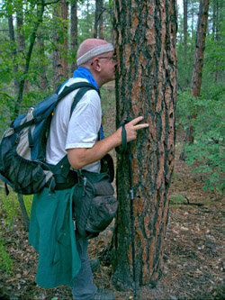 Chuck encounters an obstacle. Or maybe a couple of squirrels. Or maybe a sweet spot. Or maybe this is a trick photo. Or... [photo by Wayne] |
|
The gate in the photo at the left marks the west junction of the side trail connecting to Upper Goldwater Lake. This is a handy waypoint. By taking the side trail we did, in fact, end up at the actual lakeshore. Upper Goldwater Lake isn’t big - less than half a mile long - but it’s still a treat for anyone who lives in Arizona. The lake was full of boaters and kayakers and fishers but no swimmers. |
 Boats on Upper Goldwater Lake and Quy on the shore. [photo by Jim] |
 Funyung and Ed relax as Chuck approaches and Quy snaps photos. A beautiful spot. [photo by Jim] |
|
I guess the stretch we followed along the lake is part of the Bannon Trail, which extends from the city park south and around the lakeshore. It isn’t marked, though, perhaps because it’s only 0.6 miles long. But it’s still a very pleasant spot. |
 Funyung and Ed pass the time as Chuck gets organized. [photo by Jim] |
|
A small boat pier marks the city park’s location from the lake. Had we known this, we could’ve left our cars at the park entrance we originally tried, taken the Bannon Trail to its end, and then taken the connecting trail to the main route. But oh well, and then we couldn’t have said we’d hiked the entire Goldwater Lakes Trail! |
 The city park include the lake, the pier, a collection of buildings behind it, and a variety of short easy trails. [photo by Jim] |
|
An alternate for this hike might be starting at the White Spar campground, hiking to the park, having lunch, enjoying the facilities, and then hiking back to the campground. To finish the hike we took another short connector trail up and southeast to the main #396 trail. This trail was a little faint at times but easily passable. Afterward we stopped at El Gato Azul, a Spanish (not Mexican) restaurant in downtown Prescott. The food was enjoyable and unique, the camaraderie was great, and we were able to sit outside overlooking Granite Creek and a trail that runs beside it. All in all it was a great day and a very enjoyable hike. Thanks to all who participated! |
| Hike Statistics | |
| Total Distance: | 9.68 miles |
| Time Moving: | 3:42 |
| Time Stopped: | 1:46 |
| Avg Speed Moving: | 2.6 mph |
| Avg Speed Overall: | 1.8 mph |
| Trailhead Elevation: | 6146 feet |
| Maximum Elevation: | 6164 feet |
| Total Elevation: | 1029 feet |
| Start Time: | 8:50 AM |
| End Time: | 2:18 PM |
 Top of Page
Arizona Trailblazers Hiking Club, Phoenix, Arizona
Comments? Send them to the AZHC .
updated March 31, 2017