| |
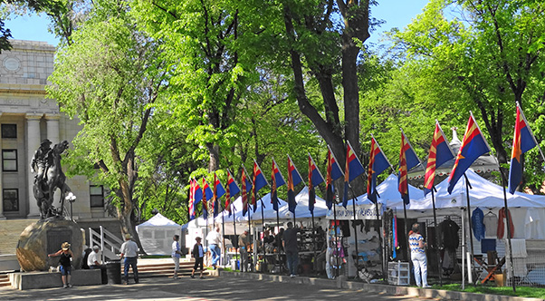
Historic Courthouse Square in downtown Prescott. [photo by Dave]
|
|
We had earlier decided on Courthouse Square as our Prescott rendezvous
point before striking out for the Granite Mountain Trailhead. The
square is a beehive of activity this morning, with a busy weekend of
bazaars and festivals scheduled for the area. We can’t afford to stick
around here too long, so we caravan straight away for the trailhead.
Although I drew up our official route map for today’s hike, somehow
Randy and I manage to zip right past the Montezuma Street turnoff
and have to backtrack a couple of miles to link up with the rest of
our group. Montezuma Street turned out to be a lot closer to Courthouse
Square than I realized. When we finally hit Iron Springs Road, we are
on course all the way to the trailhead.
|

Arizona Trailblazers on the Granite Mountain Trail. [photo by Dave]
|
|
From left to right:
Steven, Jeff, Kathy, Dottie, Mark, Quy, Debbie, Anikó, Randy, Nicole,
Michael, and Chuck, with Dave behind the camera lens.
On a beautiful,
albeit a tad warm, Saturday morning in mid-May a Baker’s Dozen
of Arizona Trailblazers gather for our group picture about a quarter
mile down the trail from the Metate Trailhead which marks the beginning
of Granite Mountain Trail. Unfortunately, we can’t find a
third-party photographer for the task so Dave volunteers for the honors.
Today’s hike marks exactly eleven years to the day since the old
Motorola Hiking Club (our original name) last did this hike back on
May 12, 2001. Amazingly, today’s weather is almost identical
to that day eleven years ago—sunny and warm, with clear skies and a
9:30 AM starting temperature of 80 degrees, far warmer than
normal for this time of year at 5,600 feet. This, despite the latest
NOAA National Weather Service forecast for a high of only 74 degrees
for the day on Granite Mountain. Wonder if I should have gone into
weather forecasting instead of widget making?
|

Prescott National Forest Granite
Mountain Wilderness boundary sign. [Chuck]
|
This rugged wooden sign marks the official boundary of Granite Mountain
Wilderness, a 9,762 acre preserve within Prescott National Forest, and
is located about a quarter-mile from Metate Trailhead.
Perhaps it’s just my imagination running wild, but whenever we
pass these wilderness boundary signs on our hikes I get the uneasy
feeling that we’re leaving behind a known safe zone and entering
into the great unknown, a fraught-with-danger wild and woolly place
where giant cave bears and saber tooth tigers, marauding beasts twice
as large as normal, roam freely in search of human prey.
Yup, the imagination running amuck and totally out of control again.
Granite Mountain was originally known as Mount Gurley and named in
honor of John A. Gurley, the first governor of the Arizona Territory.
Unfortunately for the governor, the name was short-lived and
eventually lost out to, of all things, a rock.
|
|
The overwhelming predominance of Precambrian Granite throughout
the area, especially this mountain of granite that soars to 7,626
feet northwest of the city of Prescott, prompted the name change.
But as a consolation prize for the former Guv, Gurley Street is
today one of Prescott’s major thoroughfares.
|

Rocks, trees, and more rocks. [Chuck]
|

Soaring cliffs along Granite Mountain’s South Face. [Dave]

Peregrine Falcon nest site on the cliff face. [Steven]
|
Not too far from the trailhead hikers can see this sheer 500-foot
high granite cliff on the mountain’s south face.
Granite Mountain is a popular location for rock climbers from
around the Southwest, and this cliff face is one of the best
locations for rock climbing in all of Arizona, attracting
thousands of climbers to the area each year.
These sheer granite cliffs are also ideal nesting sites for Peregrine
Falcons, as seen in this picture taken by Steven. The falcon nest
is located on the ledge circled in red. To protect the species during
nesting season, the Forest Service closes these cliffs to all
climbing activity from February through July.
Peregrines are legendary in their dives for prey, having been clocked
in excess of 200 MPH, making them the fastest birds in the world.
|

|

|
|
Manzanita and pine trees seen along Granite Mountain Trail.
[photos by Dave]
|
|
Pinyon pine, manzanita, alligator juniper, numerous species of oaks,
and scattered Ponderosa pine line the trail and populate the slopes
of Granite Mountain. Although we see evidence of past forest fires
in the area, there doesn’t appear to be any significant bark
beetle damage to these trees despite the fact that almost 50% of
Prescott National Forest has been decimated by bark beetles over
the past decade or so. And as this report is being written, a major
wildfire tagged as the Gladiator Fire has already chewed its way
through 14,000 acres of Prescott National Forest northeast of the
Crown King area, with little containment to stop its progress.
Between massive bark beetle destruction and prolonged drought
induced stress, Arizona’s forests are under major assault
and losing ground year by year.
The largest wildfire in Arizona’s history occurred just last
year, with the destruction of 540,000 acres of prime timber
in the Apache-Sitgreaves National Forest in eastern
Arizona’s beautiful White Mountains.
|
|
The 1.3 mile stretch of Granite Mountain Trail between Blair Pass and
Granite Mountain Saddle climbs steadily for over 900 feet through a
long series of switchbacks on the way to the summit.
This is just one of many spectacular views along the way.
|

The cliffs of Granite Mountain towering over the trail. [Chuck]
|
|
Dave, Kathy, Dottie, and Randy take time out to admire this huge
alligator juniper sitting right at the edge of the trail.
Granite Mountain has some of the largest alligator junipers we have
ever seen in Arizona, and this particular one is probably the
largest juniper along the entire trail.
|

Massive alligator juniper at trail’s edge. [Chuck]
|
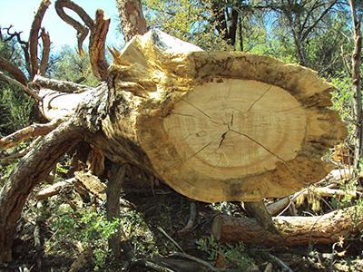
Can you count the tree rings? [photo by Nicole]
|
This huge Ponderosa pine fell across the trail some time ago, and
a section was cut out to allow passage on the trail.
We’ve seen Ponderosa in the past up to 8 feet in diameter and
over 100 feet tall. Although this fallen giant is not one for
the record books, it’s still pretty darned impressive.
Can you count the exact number of tree rings on this trunk?
If so, you’re a better Dendrochronologist than me.
|
|
Anikó is one of our newer members and also one of our faster
hikers, typically in the lead group on most hikes.
You can see a shy smile peeking out from under her hat in this
picture, while many of us have our tongues hanging out in the
breeze, gasping for air.
|

Anikó charges up the trail. [photo by Steven]
|
|
Now what can this particular discourse be all about? Hiking ethics?
Geology? Photography? The history of Granite Mountain? Quantum
Mechanics? Astrophysics?
Not quite sure, but the group seems to be completely enthralled
by the lively discussion taking place here.
|

Group discussion led by Michael H. [Dave]
|

Moby Dick on Granite Mountain? [Dave]
|
A solid granite Moby Dick, frozen in both time and stone, seems to be
pushing his way through to the surface in hot pursuit of Captain Ahab.
Who knows if he will ever succeed, but he will surely keep on trying
since Moby is one darned persistent whale you don’t want to tangle with.
|

Kissing Rocks on Granite Mountain? [Nicole]
|
This picture by Nicole reminds me of other similar rock formations
we’ve seen over the years along the Heart of Rocks loop trail
in the Chiricahuas or the Wilderness of Rocks Trail on Mt. Lemmon.
|

Jack and the Beanstalk? [Steven]
|

What the heck is this? [Chuck]
|
|
We finally locate the famed bean stalk but, alas, Jack is nowhere
in sight. However, this “bean stalk” is actually a yucca
sending its blooms soaring skyward in its final act as it attempts
to propagate itself and perpetuate the species. Once completed,
the plant will wither and die and the stalk will eventually come
crashing back down.
Animal, plant, or mineral? If you guessed animal, you are wrong.
Sorry, but no alligators in these parts – just not enough
water here and completely wrong area of the country.
But if you guessed plant, you are absolutely correct.
This is in fact a close-up shot of alligator juniper bark, from
the very same large juniper seen in the earlier picture.
The last stretch of trail from Granite Mountain Saddle to Granite
Mountain Vista climbs another 500 feet in a little over a mile
through scattered stands of tall Ponderosa pine, providing the best
shade along the entire trail. The final home stretch of trail levels
off before one last rise over a section of slick rock out to the
vista point.
|
|
Perched near the edge of a rather precarious looking granite outcropping,
Steven and Nicole pose for a quick picture near Granite Mountain Vista.
Whatever you do here, don’t even think about taking one tiny step
backward and, in fact, don’t even sneeze. Oh, and just one more thing.
If you feel the ground shaking, run like hell!
|

Daredevils Steven and Nicole.
|

Living testimony to sheer tenacity. [photo by Nicole]
|
Although the interior of this large alligator juniper was totally burned
out and charred and its lower trunk virtually gutted, most likely by a
lightning strike, somehow the tree has managed to survive and even thrive
with plenty of new growth in its crown.
This would have killed most trees, but junipers are legendary survivors
of both fire and extreme drought and even seem to be resistant to bark
beetle attack as well.
But in the natural world this is just one of many examples of how life
hangs on and often thrives in the face of overwhelming adversity –
a valuable lesson we humans should all take to heart.
So if I come back in the next life as a tree, I sure hope it’s
an alligator juniper.
|

“Leaves of three, let them be.” [photo by Nicole]
This is the mantra that Randy repeatedly drills into us as he points out
the many clumps of Arizona poison oak along much of the trail.
Brush up against this nasty stuff and you can break out in a severe rash,
especially if you’re highly allergic as he is.
Randy relates his woeful encounters with perilous poison oak when he was
younger, spending many a summer covered in both the rash and a special
ointment used to treat it and relieve the horrific itching it causes.
Wearing long pants is a definite plus whenever hiking in poison oak
country since most of it is too low to the ground to brush against
anything other than your legs.
|

View from Granite Mountain Vista. [photo by Chuck]
|
|
The sweeping views from Granite Mountain Vista take in much of the
town of Prescott, Granite Basin Lake, the Granite Dells, and the
Bradshaw Mountains in the distance.
|

Granite Basin Lake from the vista point. [Chuck]

Not the real summit, but pretty close. [Chuck]
|
Aside from the town of Prescott, Granite Basin Lake is the most
prominent feature seen from Granite Basin Vista. The Civilian
Conservation Corps completed work on the dam for this lake way
back in 1939, and the lake has been a prime recreation area for
the people of Prescott for many years.
The trail comes to an abrupt end just below this “lesser
summit” of mammoth granite boulders that peaks out at
7,185 feet. Roughly a half mile northeast of here and unseen
from our location, the true summit of Granite Mountain rises
another 441 feet to top out at 7,626 feet.
If we were hard-core rock climbers we probably wouldn’t
think twice about going for the summit, but since we’re
just hard-core hikers this will be our turn-around point
before heading back down the mountain.
|

Lunch on Granite Mountain. [photo by Steven]
|
We finally arrive at Granite Mountain Vista about 12:30 PM and just in
time for a lunch break. The group splits up, with some of us hanging out
in the lower area in this picture and others deciding to move up a little
higher among the larger boulders.
There’s scant shade to be found around here, but at least the air
is cooler at our nearly 7,200 foot elevation and we catch an occasional
cooling breeze blowing up the mountain.
|
|
Debbie and Michael share a Four Peaks Amber Ale, as Mark and
Anikó look on. After a long, hard hike there’s nothing
like sitting down with good friends and an ice-cold brew or
an ice-cold soda or an ice-cold anything else for that matter.
|

Post-hike libation. [photo by Steven]
|

A little R&R after returning to the trailhead.
[photos by Steven]
|

Prescott Brewing Company’s best brew sampler.
The dark chocolate flavored brew emerges as the clear winner
among this lot.
|
|
Part of our group decides to head back to the Phoenix area after
the hike, while most of us take a well-deserved break at the trailhead
and discuss our options for a post-hike dinner. We decide to stay in
touch via our Motorola TalkAbout radios and meet up for dinner somewhere
along Prescott’s famed Whiskey Row.
We’re also curious to check out the recent fire damage that
destroyed several businesses in the area.
|

Trailblazers enjoying dinner at the Prescott
Brewing Company.
[photo by Steven]
|
Clockwise: Debbie, Steven, Michael, Randy, Chuck, Mark, Nicole,
and Anikó.
From the seemingly endless crowds lined up and
waiting to be seated here, the Prescott Brewing Company seems to
be the place of choice for visitors and locals alike along downtown
Whiskey Row. We’re certainly not disappointed and will be back
again some day after another Prescott area hike.
H’mm – I wonder what garlic flavored beer would taste like?
|
|
 Top of Page


