Outdoor Links
Hike Arizona
Trip Planning Guide
Trip Report Index
Calendar of Events
Library
On The Arizona Trail South of Roosevelt Lake
November 13, 1999
by Chuck Parsons
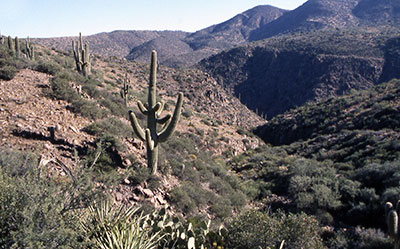 Descending into Cottonwood Canyon Our destination was Cottonwood Spring, a mini-oasis of cottonwoods, sycamores, willows, and grapevines in a lush riparian habitat surrounded by the comparatively harsh Sonoran Desert environment of Tonto National Forest. The Cottonwood Canyon Trail is part of the 750-mile long Arizona Trail, which traverses the state from Mexico to Utah. Originating at the Coronado National Memorial on the Mexican border below Sierra Vista, the trail heads north through the lower Sonoran Desert of Southeastern Arizona, crosses the Santa Catalinas northeast of Tucson and then the Mazatzals near Payson, before winding through the San Francisco Peaks north of Flagstaff, then across the immense chasm of the Grand Canyon and the Colorado River, and finally crossing the Kaibab Plateau north of the canyon before terminating at the Utah border. The first half mile of the Cottonwood Canyon Trail gently ascends a low ridgeline alongside a desert wash parallel with Roosevelt Lake, offering spectacular views of the lake as we slowly gain elevation. For the next half mile we are hiking in the more lush and green riparian area of Thompson Spring, now reduced to a mere trickle and a few nearly stagnant pools in this dry and abnormally warm late autumn season. After one mile of relatively easy and pleasant hiking, the trail now connects with Forest Road 341, which would serve as our path for the next two miles as it clawed and chewed its way up a steep ridgeline parallel to Cottonwood Canyon. The easy part was behind us, and we were now faced with a challenging two-mile climb over this very rough and rocky terrain that passes for a forest road, but in reality is little more than an unmaintained four-wheel drive jeep trail that would be a challenge in some places for most jeeps. We knew it was going to be even more of a challenge coming back down on this treacherous loose rock. |
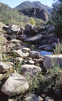 Quiet reflecting pools from the spring The magnificent views, however, did offer ample reward and compensation for our efforts, as we steadily climbed higher and higher on this ridgeline alongside Cottonwood Canyon. There were outstanding views of Roosevelt Lake, now well over one thousand feet below us and sparkling like a jewel in the distant setting of the Sonoran Desert. Towering, weathered copper-colored cliffs stand as sentinels overlooking the canyon, and rough, jagged walls of weathered granite and conglomerate plunge deeply into the unseen depths of this mysterious and beckoning canyon that is our ultimate destination. At long last we finally reach the end of this rock and boulder filled jeep trail and link up with the lower end of Trail 120 at the north end of Cottonwood Canyon. Tired and overheated, we pass by a large metal water tank next to an empty corral. Filled to the brim with icy cold spring water, it beckons enticingly for us to jump in for a refreshing cool dip, but after a short break we decide to push on into the depths of the canyon, eager to reach our final destination of Cottonwood Spring, some three miles in the distance. Ancient and towering cottonwoods, sycamores, and willows line the length of this canyon and provide welcome shade from the hot sun high overhead. It seems as if we have just entered a different world, but a quick glance toward the surrounding foothills covered in forests of stately Saguaros quickly reminds us that we are not really very far from the desert after all. These riparian areas of the Sonoran Desert are truly unique and special places, offering safe refuge and a cool retreat to an amazing variety of plant and animal species that could not survive in the relatively harsh and unforgiving desert environment only a short distance away on either side of the protected streambed meandering through this cool and shady canyon. The trail now starts to crisscross the meandering Cottonwood Creek, normally flowing year-round. |
|
However, in this very dry and warm late autumn season it disappears underground, unable to stay on the surface with its greatly reduced flow that sinks out of sight into the sandy streambed from time to time. Cottonwoods and sycamores are just starting to put on their fall colors of yellow and orange, half turned by now, despite the warm fall weather in this canyon country. |
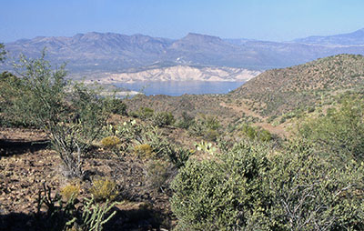 View of Roosevelt Lake from the upper trail. |
|
Although well marked in most places by giant three-foot high rock cairns, the trail now seems to vanish mysteriously at times as it crosses the creek. Occasionally, we are forced to hike through the dry streambed for awhile before we can catch sight of the wayward trail snaking its way through the brush in the distance. We soon find ourselves bushwhacking through overgrown areas of this little-used trail (we would not see another soul on this trail for the entire hike). The battle scars that we all came away from this hike with are evidence of our many encounters with Catclaw Acacia, also known as “cowboy’s sorrow” because of their vicious curved thorns that leave their mark on all passers-by unfortunate enough to cross their path. Pushing ever deeper into Cottonwood Canyon, it isn’t long before we startle and flush a large covey of quail, the distinctive rapid drumbeat of their retreating wings vibrating the air around us as they beat a hasty retreat. The fact that this experience would repeat itself numerous times along this canyon trail was testimony to the rich abundance of wildlife present in this canyon retreat. Another form of not-so-welcome wildlife in abundance were the numerous and pesky wasps we would encounter throughout the canyon. We have never seen so many wasps on any previous hikes, and would all get buzzed from time to time by these persistent little devils, who were determined to stay in our faces and force us out of their territory. Breaking for a well-deserved lunch around 12:15 PM in a shady glen alongside the trickling Cottonwood Creek, it wasn’t long before the angry horde was buzzing us again, forcing us to retreat from this otherwise very pleasant area of the canyon. Continuing on our way up the canyon for another half hour, we were still about one and a half miles short of reaching Cottonwood Spring at the upper end of the canyon, when we made a decision to turn back at about 1:15 PM and start our 4.5 mile return trip to Frazier Trailhead. We were tiring out a bit by now and felt that we would really be pushing it to attempt to reach the end of the canyon and make the six-mile return hike back to the trailhead before darkness fell in this canyon country. The hike back out the same route was relatively uneventful, except for the tarantula we sighted along the trail, probably frightened out of its hiding place by our passing footsteps. After taking a couple of pictures, we left it to return to its burrow and do whatever it is that tarantulas do. |
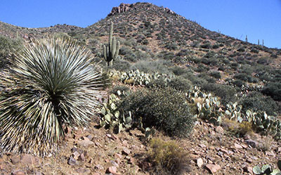 Desert views along the trail. |
Back on the forest road, one last die-hard wasp was determined to give me a final send off I would not soon forget by launching a sneak attack, crawling under the sleeve of my T-shirt and injecting my left arm – a clear warning not to return to its territory any time soon without suffering the consequences. These guys weren’t bluffing after all. |
|
The hike back down the steeper portions of this road was going to be a real challenge, requiring full concentration and very careful footwork on the loose rock and rubble-filled areas to avoid a long tumble down the hill. Luckily, we all made it down without major mishap, although I did take an embarrassing spill somewhere along the upper half of the road, losing my footing on one of the loose rock areas. We finally arrived back at the trailhead by 4:00 PM, with plenty of daylight to spare. After stowing away our gear and massaging tired and aching feet and sore leg muscles, we decided to stop at the general store near the new Roosevelt Visitor Center and take a short break, while stoking up on ice-cold sodas, pretzels, and salty peanuts before starting the long drive back to the valley. The unseasonable heat, the long tough climb up Forest Road 341 (and the equally challenging hike back down), the Catclaw Acacia encounters and resulting scratches, and even the angry wasp hordes could not outweigh the good and lasting memories of this wondrous and special place in this equally wondrous and special state that we call Arizona. |
 Top of Page
Arizona Trailblazers Hiking Club, Phoenix, Arizona
Comments? Send them to the AZHC .
updated December 16, 2017