Outdoor Links
Hike Arizona
Trip Planning Guide
Trip Report Index
Calendar of Events
Library
Hiking the Santa Catalinas —
Southern Arizona’s Sky Island
October 14, 2000
by Chuck Parsons
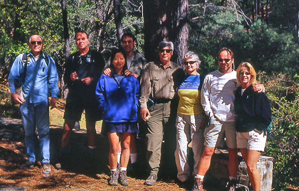 Chuck, Loyd, Yu-Ling, Dave, John, Dorothy, Bill, Machell |
|
On a cool and cloudy October morning, with a nice hint of Fall finally in the air for summer-weary desert dwellers, eight Motorola Hiking Club members started out on a journey from the outskirts of Phoenix to the top of Mt. Lemmon in the Santa Catalina Mountain Range north of Tucson. Loyd Cook, John and Dorothy Hilty, Dave and Yu-Ling Langford, Bill and Machell Short, and yours truly, Chuck Parsons, reached the base of Mt. Lemmon shortly before 10:00 AM for the start of our 25-mile drive up the spectacular and breath-taking Catalina Highway, one of the most beautiful and scenic drives in all of Arizona. Named after botanist Sara Lemmon, who in 1881 became the first woman to reach the top of this mountain that would later bear her name, Mt. Lemmon, at 9,157 feet, is the highest point in the Santa Catalina Range. Our one-hour drive to the top of this sky island would carry us through six major life zones, equivalent to a thousand-mile journey from the lower deserts of southern Arizona to the Spruce-Fir forests of southern Canada. From the Lower Sonoran Desert at the 2,850-foot base of Mt. Lemmon, we began to encounter the first of many loops and switchbacks to come on this long and winding road to our trailhead. Before long, we find ourselves at the 4,000-foot level of the Upper Sonoran Desert. Around and around the curves and through the switchbacks we go, gradually but steadily gaining elevation, with the city of Tucson becoming more and more distant after climbing each series of switchbacks on our way to the top of this mountain. By 5,000 feet we have begun to leave the last traces of desert behind us, as we enter the realm of the Oak Woodland zone. Continuing our serpentine climb, at 6,000 feet we are seeing an increasing number of tall pine trees, as we enter the Pine-Oak Woodlands zone. It is also at about this level that we start to encounter reminders of the city, now far below us, in the form of road construction. |
|
The wear and tear of traffic and the harsh winter weather of these mountains have apparently began to take their toll on this highway that was completed in 1950 with the labor of a total of 8,000 prison inmates, who toiled for almost 18 years to finish it, starting the job with nothing more than shovels, pick-axes, and wheelbarrows. We began to appreciate this highway even more now (even with the $5.00/vehicle toll charge), despite the slow down by construction activities over the next five miles or so. Steadily ascending, at about 7,000 feet we enter the kingdom of the mighty Ponderosa Pine, the true giants of these mountains, towering up to 130 feet in height and some with trunks up to six feet in diameter. We finally top out at the 8,000-foot level of the Mixed Conifer Forest of Blue Spruce, fir, and pines, before passing through the picturesque little village of Summerhaven and coming to journey’s end at the Marshall Gulch Trailhead at 10:45 AM. It is a sunny and refreshingly cool 60° F at the 7,410-foot trailhead that would take us to the top. |
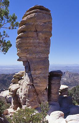 Spectacular columns of rock along the upper Catalina Highway. |
|
After a slight change of plans, we decide to start out on Marshall Gulch Trail #3 and return via Aspen Trail #93, reverse order of our normal agenda for this hike. The Marshall Gulch Trail, part of the 750-mile long Arizona Trail, runs parallel to a fork of Sabino Creek, now reduced to a trickle on this early autumn day. |
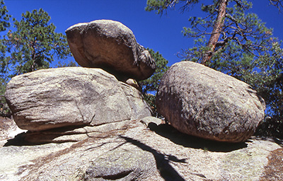 House-size boulders along the Aspen Loop Trail.
|
Crimson leaves of the bigtooth maples that are so abundant on this stretch of the trail carpet our path, as we make our ascent on this steadily climbing trail to Marshall Saddle at 8,400 feet, passing through thickets of Arizona alder, maples, willows, and Douglas and white fir. We noticed a number of squirrels along the trail, now busily gathering acorns and pine nuts to store away for the long winter months that lie ahead. |
|
It became apparent right from the start that Bill and Machell Short were going to be our point leads on this hike, quickly taking the lead on the first set of switchbacks we encountered. It would prove to be a real challenge for the rest of us to keep up with these two, who were obviously part mountain goat, with their level of stamina and endurance. Machell had apparently decided to use this hike as a hard core training exercise for her upcoming Scottsdale Desert Classic Marathon, scheduled for next February. I believe about the only thing actually holding her back from charging uphill at a full run was the high elevation and the fact that she does not reach her optimum performance level until the air temperature approaches about 90° F, something we would thankfully not see on this pleasantly cool fall day in the Catalinas. The prickly little goosebumps seen from time to time on Machell’s arms were clear evidence that the cool 55-60° F temperatures of Mt. Lemmon were just too darned cold for this heat loving desert dweller and native Arizonan, who would probably have been much more at home with us last week in the Grand Canyon’s Inner Gorge, where we experienced scorching temperatures of 105° F on our 17-mile “Death March”. (See Mike Wargel’s October 7 Grand Canyon trip report for full details.) Machell’s husband, Bill, was certainly holding his own, despite an on-going foot problem that didn’t seem to bother him in the least bit in his quest for the top of the mountain. Hope you get that foot problem resolved soon, Bill, so you can do more hiking with us in the future. The best of luck to you, Machell, in your marathon next February. I believe you are going to do just fine. The workout you are getting today should help a little. |
|
Continuing our climb up the Marshall Gulch Trail, as it wound its way through the forest and crossed the creek several times, we continue to play catch-up with Bill and Machell, forging ahead in the distance. Shortly before noon, we reached the Marshall Saddle junction at 8,400 feet, a climb of 1,000 feet in 1.2 miles. This would prove to be just a warm up hike for what lay ahead for most of us. After catching our breath (some of us, anyway) and taking a short rest break, while discussing our options, John and Dorothy Hilty and Loyd Cook made a decision to take the return loop, Aspen Trail, back to the trailhead. Loyd had brought his mountain bike along and wanted to do some biking in Saguaro National Park, while there was still plenty of daylight left. Meanwhile, Bill, Machell, Dave, Yu-Ling, and I decided to tackle the 1.5-mile summit trail to the top of Mt. Lemmon. We decided we had come this far, so why not go all the way to the top, since there was still plenty of time left and none of us had hiked to the top of Mt. Lemmon before. |
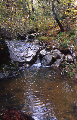 Water is flowing in the Santa Catalinas. |
|
Using our trusty Motorola TalkAbouts, we maintained radio contact with our returning party of three until they reached the trailhead, as we started on the first of many switchbacks to come on this trail. Much to our dismay, Bill and Machell showed no signs of tiring or slowing down, as they charged up one series of switchbacks after another. What is it with these two anyway-don’t they ever get tired? I wonder if they were secretly popping some sort of pep pills back at the parking lot? C’mon guys, give us a break, will you? By this time, Yu-Ling’s right knee was starting to give her a problem, as the constant pounding on this rocky trail was beginning to take its toll. Luckily, I had an Ace Bandage in my first-aid kit, and we were able to brace her knee with it, so she could continue on in relative comfort and complete the hike. To Dave’s credit, he is normally a pretty aggressive hiker (we tackled Mt. Humphreys together last year) and would probably have kept up with Bill and Machell, but was holding back for Yu-Ling and her bad knee. After another twenty minutes and untold numbers of switchbacks (this trail is starting to remind me of the dreaded Jacob’s Ladder I encountered on the Bright Angel Trail in the Grand Canyon just last weekend), we decided to take a short rest and break for lunch, since it was now close to 12:30 in the afternoon. Since Lunch Ledge was on the Aspen Trail that we would follow back to the trailhead in the footsteps of John, Dorothy, and Loyd, we settled on a nice substitute we quickly dubbed Lunch Rock. Lunch Rock was a small granite outcropping that provided us with a spectacular view of the surrounding forest and towering granite formations of the Santa Catalinas, stretching out before us to the horizon. After an enjoyably half-hour of lunchtime conversation (including a great bear joke that we won’t go into here) and taking in the terrific scenery around us, we decided to push on to the summit-somewhere up there in the distance. |
|
Machell’s arms are now full of little goosebumps once again. Sitting on that cold granite rock just a wee bit too long, were we Machell? Actually, to tell you the truth, I’m starting to feel a little like a Popsicle now myself, with these cold autumn winds sweeping up from the slopes below us. I bet we would all be real Popsicles sitting out here next January. Time to move on and get that blood circulating again. |
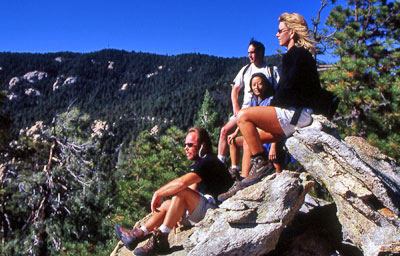 Bill, Dave, Yu-ling, and Machell enjoy the view from a rocky perch. |
|
Onward and upward we continue on our quest, determined more than ever to reach the top of this mountain before nightfall (did I bring those extra flashlight batteries this time?). Energized by the refueling stop, Machell and Bill are showing us no mercy at all, as they race up the ascending switchbacks, seemingly oblivious to the fact that the air is getting thinner and thinner as we near the top. By now, I am really starting to suspect they are secretly snorting oxygen from their hidden miniature oxygen canisters (probably disguised as water bottles) along the way, but cannot be certain, since they are so far off in the distance. After what seems like about a hundred or more twisting and torturous switchbacks, we finally emerge at 1:30 PM in a sunny clearing that we strongly suspect to be the summit of Mt. Lemmon. Could it really be? I secretly pray that it is, as I casually walk about and mill around the area, pretending to be taking pictures, while trying to conceal my gasping for breath and keeping my pounding heart from sounding too obvious or perhaps even exploding. After thoroughly checking out the area, we discover that a number of other people are also milling about, having just come off the top of the Mt. Lemmon ski lift, much to our surprise. That should be proof enough for us, but just to be on the safe side, we look around carefully to verify that there are no other surroundings higher than we are. Having discovered none, we now conclude (much to my relief) that we have indeed finally reached the 9,157-foot summit of Mt. Lemmon. We rejoice, one and all. We are now at the highest point in the Santa Catalinas, and it’s all downhill from here! Sure it is, and if you believe that, I have some special beachfront property in Arizona to sell you. |
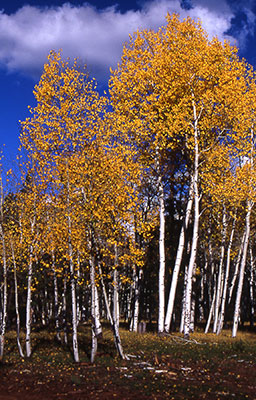 Signature fall aspen along the trail. |
After taking a group picture to prove we were really here, we started back on our long journey down the mountain to Marshall Saddle and the trailhead. Quickly making our way down through all of the loops and switchbacks that I secretly cursed under my breath on the way up, we finally reached the saddle by about 2:30 PM on this glorious afternoon in the Catalinas, with bright sunshine filtering down through the forest canopy high overhead. Shortly beyond the Marshall Saddle, we were able to locate Lunch Ledge and decided to take one last rest break on this massive granite outcropping that provided us with absolutely stunning views of Lemmon Rock, Romero Pass, and the Wilderness of Rocks area-all against the bright cobalt Arizona sky, with fluffy white clouds scurrying across the heavens. What a view – only in Arizona. After a good twenty-minute rest break, we reluctantly give up our great view and hit the trail once again for the final 2.4-mile leg of our return journey to the trailhead, via the Aspen Trail. |
|
As we quickly make our way down (and, yes, up as well) the Aspen Trail, we are hoping to see the signature Aspen trees showing some fall colors on this beautiful mid-October afternoon. For the present, we are passing through thick forests of Douglas and white fir, Ponderosa pine, Gambel and silverleaf oaks, and Arizona madrone. Just when we think we have conquered the last uphill portion of this trail down the mountain, yet another looms in the distance. It would be almost two miles before we finally reach the Aspen groves this trail is named after. Unfortunately, it seems that we are just a couple of weeks too early for the fall colors. The weather has just been too warm at this elevation for the trees to even start turning. Even though they are not yet showing their trademark golden yellow fall colors, the Aspen are spectacular, nevertheless, in their immense size. This grove contains some of the tallest Aspen trees to be found anywhere in Arizona, with some stretching close to 75 feet or more into the bright blue Arizona sky. The last half-mile to the trailhead is probably the most impressive part of this trail, for in addition to the signature Aspen trees, with their leaves rustling and quaking in the gentle breezes blowing through the canopy high overhead, it provides us with awesome views of the immense granite walls, towers, and cliffs of the upper end of Sabino Canyon. It isn’t too long before Dave, Yu-Ling, and I join Bill and Machell back at the parking lot, where they are relaxing and enjoying a couple of cold ones. What – no hot coffee or hot chocolate to warm up with, guys? The time is now 4:00 in the afternoon, and we have a long drive down the mountain and back to Phoenix ahead of us, but let’s worry about that later. For now, we will pack away our gear, clean up a bit, and kick back, while savoring this cool, clean mountain air for awhile longer (that’s not a heavy sweater you have on, is it Machell?) and talking about, among other things, this terrific hike we just completed to the top of Mt. Lemmon and back. All too quickly though, the time slips by, and by 4:30 PM we say our good-byes to one another and head back down the long and winding Catalina Highway and out of this magnificent island in the sky of southern Arizona. Now it may just be my imagination playing tricks on me, but as we slowly make our way down the highway, I seem to hear the mountain softly whispering to us, beckoning us to return again one day to be enchanted once more by its many charms and its breathtaking beauty. We will be back – that’s a promise. A special note of thanks goes to Machell Short for being such a great sport and helping greatly to enrich this trip report. You have been a good friend, Machell, and an inspiration in the writing of this report. Thanks for all of the joy, laughter, and happiness that you share with everyone around you. |
 Top of Page
Arizona Trailblazers Hiking Club, Phoenix, Arizona
Comments? Send them to the AZHC .
updated August 9, 2017