| |
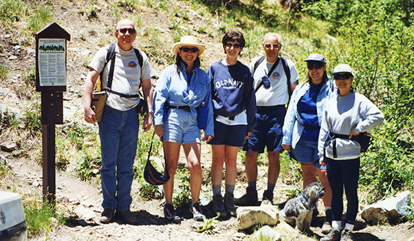
Chuck P., Monica, Michelle, Chuck G., Violet, and Ellen at the Aspen Loop Trailhead.
|
|
Most hiking reports start at the trailhead, since the main goal of the
day is obviously the hike itself; while the drive there is usually pretty routine
and secondary to the actual hike.
|
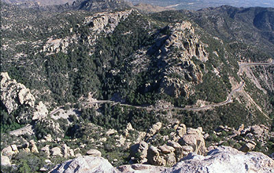
Catalina Highway in the Santa Catalina Mountains
We are going to make an exception in this case, since the thirty-mile drive from
Tucson on the Catalina Highway to the upper reaches of Mt. Lemmon in the Santa
Catalina Mountains is without question one of the most beautiful and scenic drives
in all of Arizona.
On the morning of June 5, 1999, six Motorola Hiking Club members and guests
Monica CdeBaca, Violet Dick, Chuck Giovanniello, Ellen Lan, Michelle Pagano, and
Chuck Parsons, began a spectacular one-hour journey along the Catalina Highway from
the outskirts of northern Tucson to the top of Mt. Lemmon.
Our destination at 7,420 feet was the Aspen Loop / Marshall Gulch Trailhead.
We would top out at well over 8,000 feet on this mountain before reaching it.
The Santa Catalinas are one of a number of Sky Islands in southern Arizona,
majestically rising many thousands of feet out of the surrounding desert sea,
piercing through high layers of clouds as they thrust their upper reaches so
high into the sky that they capture rains and snows that never reach the desert
floor far below.
Frequently wearing a glistening mantle of snow throughout the winter months,
they offer a very unique environment to a wide variety of plant and animal
species, and are found in few other places on Earth.
They are indeed islands of refuge for species that could not survive in the
harsh surrounding desert.
|
Tucson sprawls out below the Santa Catalinas.
|
On our journey to the top of this Sky Island we would transition through six
distinctive and major life zones, including the Lower Sonoran Desert, Upper
Sonoran Desert, Oak Woodlands, Oak-Pine Woodlands, Ponderosa Pine Forest, and
Mixed Conifer Forest.
Each of these six life zones has unique plant and animal species that thrive
primarily in that zone and transition only marginally into adjacent zones.
|
|
A one-hour trip to the top of this Sky Island is essentially equivalent in
species diversity and climatic changes to a thousand-mile journey from the
lower deserts of southern Arizona to the Spruce-Fir forests of southern Canada.
Where else but this unique place called Arizona can you take a dip in your
backyard pool in the morning and after an hour’s drive be skiing down
snow-covered mountain slopes, all before lunch? Is this a great state, or what?
Just about a half-mile beyond the picturesque little village of Summerhaven,
our road journey up the magnificent Catalina Highway came to an end at the
Marshall Gulch picnic area and trailhead. Four of us arrived at the trailhead
shortly before 11:00 AM, checked out the area and trailhead, and got hiking
gear in order while awaiting the arrival of the remaining two hikers in our
small party of six.
|
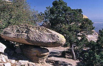
Mushroom Rock
|
By 11:30 we became more concerned with their absence, having failed several times
to reach them on the Talkabout radios (not too surprising in these mountains).
Surely they did not get lost with the well-marked road maps of the Tucson area,
including Mt. Lemmon, I had passed out earlier at our departure point in the valley.
|
|
Just after leaving a note and getting ready to hit the trail, our tardy party of
two pulled into the parking area.
They had indeed missed the Catalina Highway turnoff in Tucson and traveled for a
number of miles east into the Catalina foothills before realizing their error and
backtracking to the turnoff.
Together at last, we posed for a group picture near the trailhead, courtesy of a
fellow trekker and Chuck Giovanniello’s camera, and hit the trail at about
11:45 AM. We had already made a group decision (actually, more of a gender decision
since the four women in the group all voted no against Chuck and myself) at our
valley meeting point not to do the optional Wilderness of Rocks trail, which would
have added a minimum of 5.4 miles to the hiking distance.
With this late of a start time, that was probably a wise choice.
We all agreed this would make a great future hike; but with a minimum of 7.8
miles round trip just to reach the area, it would also mandate a much earlier
start time to maintain its day hike status.
The description of this area in one reference source sounds a lot like the
Chiricahuas: “A fantasyland of weirdly eroded granite outcroppings,
water-sculpted domes, pinnacles, and balanced rocks of every manner and shape”.
I believe this would make a terrific fall hike, probably in late September, to see
the colors of the turning aspens, maples, oaks, and alders.
The Aspen Trail starts off as a fairly steep climb diagonally across a hillside
and through a dense forest of Douglas and white fir, Gambel and silverleaf oak,
and several species of pine trees. After about a half mile, we passed through the
first of several small groves of aspens, with their trademark leaves rustling and
quaking in the soft breeze blowing through the canopy far overhead.
We were now beginning to notice portions of the trail literally sparkling in the
sunlight filtering down through the canopy and reflecting off countless small
bits and flakes of mica and quartz ground into the decomposed granite trail.
|
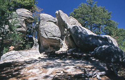
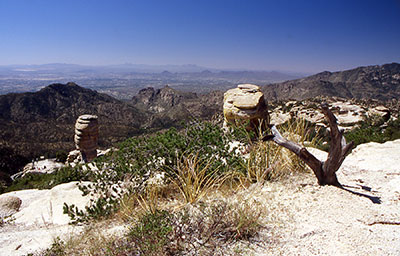
Rock formations along the Aspen Loop Trail
|
Except for the trailhead itself, the entire Aspen Loop Trail lies within the
confines of the 57,000-acre Pusch Ridge Wilderness, some of the most rugged and
unspoiled wilderness lands left in the West.
The hiking club had encountered this wilderness area just this past April on
the Romero Canyon hike, with daytime temperatures peaking in the unseasonably
warm mid-nineties.
|
|
With our high altitude the temperature was much more comfortable this time,
never rising above 60 degrees all day: perfect hiking weather.
We soon hit a series of steep switchbacks and started climbing steadily uphill
along a densely forested ridgeline into the domain of the mighty ponderosa pine,
the true giant of these forests, some with trunks 4-6 feet in diameter and
stretching upward at least 80-100 feet into the spectacularly blue Arizona sky.
It soon became apparent that Ellen was going to be our point lead, as she quickly
advanced ahead of the group and disappeared from view at times. We would catch up
with her from time to time, but at some point we lost sight of her altogether and
could not keep in contact, since she had given her Talkabout to her friend Monica,
who was bringing up the rear — slowed down by her little four-legged friend,
Chamra, who was moving along just as quickly as his four little legs could carry him.
It was now well past lunch time as we continued on, trying to locate an area known,
appropriately enough, as Lunch Ledge, which would provide us with a great overlook
of part of the Wilderness of Rocks area, while we enjoyed a well-deserved lunch
break. We were also hoping to catch up with Super Hiker Ellen at this point
(surely she would take time for lunch). After searching in vain for Lunch Ledge
and getting strong hints from Michelle and Violet, who were by now starting to
chow down right on the trail, we eventually arrived at the Marshall Gulch Junction
and decided to go just a short distance down the Wilderness of Rocks Trail (which
originates at this junction) to find an alternate lunch site. After trekking
downhill for about a quarter-mile, we finally settled on Lunch Rock and stopped
about 2:00 PM to relax and enjoy a short lunch break, while taking in the beautiful
scenery around us.
|
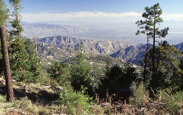
View from the upper Aspen Loop Trail.
|
|
Backtracking our way to the junction (still no Ellen in sight), we linked up with
the Marshall Gulch Trail, which would serve as our return route back to the trailhead.
This trail turned out to be a relatively easy (mostly downhill) 1.2 mile journey
through a lush riparian habitat of ground-hugging ferns, several species of small
flowering plants (sorry, no botanist among us), bigtooth maples, Arizona alders,
willows, pines, and firs. Several times we had to ford a small stream at the bottom
of the gulch, reduced down to a mere trickle now, thanks to a very dry spring this
year with far below normal amounts of rain and snowfall.
The very pleasant return loop went by all too quickly, although we were all a
little anxious to find out about Ellen and were certain we would find her waiting
for us in the parking area. At about 3:30 PM we reached the trailhead, looked
around, and still did not see her. Just as I was thinking maybe she had fallen
into a ravine somewhere and suffered a broken arm or leg or worse, she suddenly
appeared like an apparition out of the hillside on the opposite side of the parking
lot. She had returned about forty-five minutes ahead of the rest of us, got bored
while waiting, and decided to hike and explore some more. What a trooper!
We talked among ourselves for awhile, sharing a few memories of this hiking
experience in the Catalinas, packed away our gear, said our good-byes, and
started back down the Catalina Highway on our way out of these awesome mountains.
Chuck Giovanniello and I decided to stop at a few of the scenic overlooks on the
way back and take just a few more pictures in an attempt to capture the memory
and the beauty and the enchantment of this very special place in this very special
corner of the world called Arizona.
|
|
 Top of Page