Outdoor Links
Hike Arizona
Trip Planning Guide
Trip Report Index
Calendar of Events
Library
Hiking and Camping in Utah’s Canyon Country
April 16-20, 2004
by Chuck Parsons
 |
|
Although it’s never an easy task to gather a large group together for a
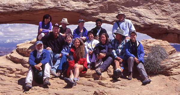
group photo opportunity, we finally manage to get almost everyone together (with
the exception of our companion, Loyd) and smiling in front of Mesa Arch, one of
the most widely recognized and photographed subjects in all of Canyonlands
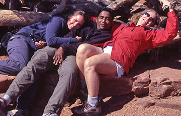
National Park. Front Row: Bill, Michael, Fran, Kathleen, Emie, Jenni, Rudy, Sharon Back Row: Eileen, Bruce, Lisa, Sam, Chuck |
|
On a beautiful Arizona Friday morning, five Arizona Trailblazers meet at a Denny’s near I-17 and Bell Road to caravan to Arches National Park, Utah. Michael Humphrey and I link up with Kathleen Green, Emie Sorongon, and Lisa Ferdinand. We depart at 8:15 AM in a three-vehicle caravan on the first leg of our 510-mile journey to Devil’s Garden Campground, located at the northern end of Arches National Park in Utah. We merge into the rushing stream of northbound traffic on I-17 and motor our way towards Flagstaff, where we refuel both ourselves and our gas-loving chrome and leather chariots. Our next stop is Kayenta in Monument Valley, where we enjoy a lunch break at the local Burger King and study a new display on the history and the significance of the Navajo Code Talkers during World War II. After lunch, we study our maps and an alternate route, suggested by Kathleen, which will take in Goosenecks State Park and great views of Monument Valley. We turn off onto Utah 261, a few miles down the road from Mexican Hat, and follow the paved highway for several miles, before it becomes a winding, spiraling dirt and gravel track that takes us to higher and more expansive views of Monument Valley, stretched out below us all the way to the far horizon. We finally reach Goosenecks by following a side road for about four miles west of Utah 261. One thousand vertical feet below us, flows the San Juan River in a tight series of convoluted twists and turns through deep canyons with a series of stepped cliffs and terraces, described as “one of the best examples of entrenched river meanders in the world.” |
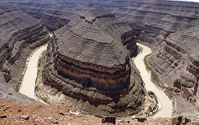 Goosenecks on the San Juan River. |
Unseen beyond our viewpoint, the San Juan continues on its meandering journey through even deeper canyons and gorges, before eventually emptying into the San Juan Arm of Lake Powell, thirty-five miles in the distance. |
|
We still have many more miles of road to travel, so eventually make our way east out to Utah 291, which will provide us with a straight track north to the town of Moab, located near the south entrance to Arches National Park. Once we reach Moab, bustling uranium boom town of the 1950s, we now have a mere 22.5 miles to go before finally reaching Devil’s Garden Campground, located at the far north end of Arches. It is a lesson in both temptation and frustration to travel this 22-mile stretch of road through Arches for the first time without stopping every few minutes to take pictures of the many breathtaking Entrada and Navajo Sandstone formations along the way, with such intriguing names as the Tower of Babel, the Three Gossips, Courthouse Towers, and Park Avenue. However, we are running short of time now and really need to get to the campground and set up our camp for the next four nights, meet our fellow campers, and fix our evening meal. It is almost 6:00 PM, Utah time, before we finally pull into Devil’s Garden Campground. |
 The majestic Landscape Arch spans 290 feet across the desert floor. |
|
As Michael and I are busy setting up our tents at Site #14, our fellow Arizona Trailblazers come over to greet us, one by one: Sharon, Eileen, Loyd, Sam and Jenni, Bill and Fran, Bruce, and Rudy. We are the true stragglers of the group–the very last ones to arrive at camp. Then again, we were the only ones to see the Goosenecks, and it was very much worth the extra time. The sun is setting low to the horizon, and a cool breeze is blowing in from the southwest (if only we knew what was in store for us later), as we set up grills and camp stoves to cook the evening meal. |
|
|
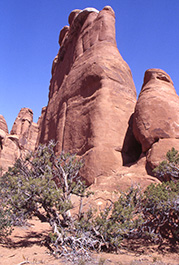
| Graceful arches and soaring pillars of Navajo Sandstone stretch skyward. | |
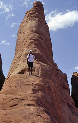
 Sharon and Eileen manage to do a little rock climbing in between hiking. |
Several of our group make their way to the camp’s amphitheater for the evening ranger talk, while the rest of us relax and finish dinner at our individual campsites. A park ranger makes the evening rounds and comes around to check our site permits, as he tells us this is a very calm evening, compared to the last few nights. Most of us later gather at Kathleen and Emie’s adjacent campsite for a few beers and conversation, while discussing the activities planned for tomorrow. As the night temperature begins to drop, and the weariness of a long day of driving sets in, we slowly migrate to our individual campsites and turn in for the night, under a star- filled night sky, dreaming of all the fascinating arches and monoliths to be discovered and photographed tomorrow in Arches National Park, Utah Canyon Country. |
|
Saturday morning dawns bright and clear in this land of more than 2,000 cataloged arches, with just a hint of clouds dancing on the far horizon. We attend to the business of fixing breakfasts and getting packs ready for the morning’s hike. After a quick round of introductions, we are off to discover our first arches, easily accessible via Broken Arch Trail, located at the lower end of our campground road. On a spur trail to Tapestry Arch, we discover a small cottontail rabbit huddled under the branches of a juniper tree, trying vainly to appear inconspicuous by remaining perfectly still and motionless. |
|
Tapestry Arch is our first arch of the day, and we study, admire, and photograph it at length, before moving on to our next two quarries – Broken Arch and Sand Dune Arch. As we pass the juniper tree once again, Mr. Cottontail is still huddled under its branches, seemingly frozen in time, until Lisa attempts to take his picture, and he suddenly springs into action and hops away to look for a more peaceful location with less human activity. |
 Emie, Sam, and Bill stand beneath Tapestry Arch. |
 Broken Arch |
 Sand Dune Arch |
|
“What are the Arches? These are natural arches, holes in the rock, windows in stone, no two alike, as varied in form as in dimension. They range in size from holes just big enough to walk through to openings large enough to contain the dome of the Capitol Building in Washington, DC. Some resemble jug handles or flying buttresses, others natural bridges, but with this technical distinction: a natural bridge spans a watercourse – a natural arch does not. The arches were formed through hundreds of thousands of years by the weathering of the huge sandstone walls, or fins, in which they are found. Not the work of a cosmic hand, nor sculptured by sand-bearing winds, as many people prefer to believe, the arches came into being and continue to come into being through the modest wedging action of rainwater, melting snow, frost, and ice, aided by gravity. In color they shade from off-white through buff, pink, brown, and red, tones which also change with the time of day and the moods of the light, the weather, the sky.” Edward Abbey, Desert Solitaire (Abbey worked as a Park Ranger at Arches during the 1950s).The trail out to Double O Arch requires an exposed walk along a relatively narrow ridge of slickrock, even more challenging with the occasional wind gusts, still blasting us with grit and sand. Double O is a unique arch, with one large oval span overlaying a second, smaller span. A few of us scramble up a slope of steep soft sand to cross through the arch and climb a stretch of steep slickrock on the opposite side for an even better view looking back through from the other side. This marks the second turnaround point for the vast majority of hikers, who return along the same route to the trailhead. I had intended on this being a one-way hike in and back out for our group as well. |
|
But Sharon Strong had talked to several hikers who returned on the primitive loop trail and indicated it was a good and safe alternate route. Since we are the Arizona Trailblazers, we do have a certain reputation to uphold, so we all decide to make the full 7.2-mile hike, via the Devil’s Garden Primitive Loop, which will add an additional three miles to our original hiking distance. |
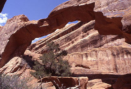
 Double O Arch |
|
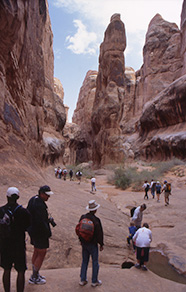
I have to give credit to Lisa Ferdinand, since she decides to complete the full loop hike with the rest of the group, despite her earlier encounter with the juniper branch, which scraped the top of her head hard enough to draw blood and cause quite a bit of initial pain. After a brief rest break and a little medical attention, including slugging down a couple of Tylenols to ease the pain, this petite, but tough, trooper is ready to hit the ground running (or at least hiking) once again. It is easy to see why this section of the trail is referred to as the primitive loop, since it is not well marked and hard to follow in places, with only the occasional rock cairn, as it traverses up and down over large expanses of hard slickrock. We head northeast through Devil’s Fin Canyon, before stopping off briefly for a view of Private Arch, reached by way of a short spur trail. As we move along through a wilderness of slickrock and deep, sandy washes, we can understand why the trail guides do not recommend this route in the event of rain or snow. |
 Devil’s Fin Canyon |
These slickrock sections would suddenly become quite true to name and turn very treacherous, and possible even deadly, when wet. Luckily, we would not encounter a drop of moisture on this dry and windy afternoon. The trail eventually swings around to the southeast, and we soon rejoin the main trail just below Landscape Arch. |
|
The group has become pretty much scattered along this primitive stretch of trail, and some have made it back to camp already, as Sam, Jenni, Michael, and I emerge through the wind tunnel entrance to Devil’s Garden and back to the trailhead. The first order of the day is to splash some cold water in the face and attempt to rinse all of the day’s accumulated grit and dust out of our eyes. On reaching the large sink outside of the campground restroom, we rinse off even more, holding our heads under the cold, running water. Even though it is not the same as a full shower, it is very refreshing nevertheless and makes one feel like a new person again. All safely back at camp, we make preparations for the evening meal. |
|
The wind is not letting up and seems to grow more intense by the hour, as I attempt to keep my propane hibachi burning. I finally give up and toss my piece of marinated salmon on the charcoal fire Michael has struggled to keep going. We eat quickly, before the wind takes away all of the heat in our food, and make our way over to the campground amphitheater, for a very abbreviated ranger talk, cut short by the wind. |
 Sharon checks out more incredible views from the overlook. |
|
Any evening campfires are now totally out of the question, and we even douse the
dying embers of charcoal, before they can blow out of the grill and become
little airborne torches. It is about 9:30 PM, and many have already turned in,
battened down the hatches, and prepared to ride out the windstorm. I settle into
the reclining bucket seat of my Dodge Dakota pickup and close my eyes, recalling
the day’s events. The winds slam into my truck broadside, causing it to
sway from side to side. Unable to sleep or relax and worried that my tent may
actually blow away without my weight inside to hold it down, I reluctantly leave
my secure steel cocoon behind and crawl into my swaying tent, which is now
heaving, pulling, and tugging – threatening to pull itself free of its
earthbound existence and become airborne at any second now.
I am thinking this is going to be a very long night, as I settle into my sleeping bag and lay back, with the winds howling and the tent bucking and heaving in every direction, as the unrelenting winds continue to pummel it. At some point during the night, one corner of the tent finally pulls free, and the tent wall rhythmically slaps me in the back of the head. The wind velocity seems to grow stronger by the minute, and I begin to wonder how much longer any of our tents can hold up under such punishment, before ripping to shreds and blowing away to an unknown tent graveyard, probably at the bottom of the canyon behind our campsite. The tent walls are now flapping and whipping around like the sails of a ship upon the open sea, under attack by screaming, 50-mph gale force winds. Next comes the distant sound of rumbling thunder and then the patter of rain pelting the walls of the tent and falling on the nearby slickrock. The rain grows more intense, as I look at my watch and groan – it is only 3:00 AM! Will this night of the wind ever end? |
 Sam–part man, part mountain goat. |
At some point during the long, windy night the wind and rain both gradually subside, and the temperature drops dramatically. By the time most of us roll out of our tents around 6:30 AM to assess the damages, it is darned chilly! A quick check of my thermometer shows a bone-chilling 37 degrees. Wintertime in Utah! With a heavy, leaden gray sky overhead, we are wondering when it is going to start snowing. Perhaps we will have to shelve our hiking plans for the day, and stay in camp instead, building snow forts and having snowball fights. Bill Ruppert is the first to report damage to his tent trailer. Sometime during the night, a Gabriel’s Arm support on one side of his tent-trailer buckled and collapsed in the high winds, partially pinning him in bed. With Fran’s help, he was able to extract himself, and both are OK, despite the ordeal. We fix breakfasts and proceed with our plans to tour nearby Canyonlands National Park today. |
|
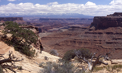
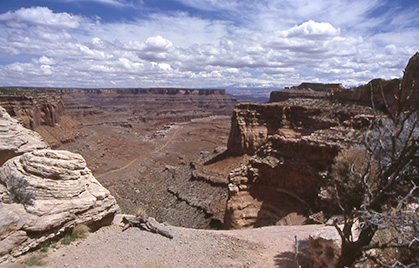
On the way to Canyonlands, about fifty miles from our campground in Arches, we stop off and visit Dead Horse Point State Park, located at the end of a four- mile spur road off Utah 313, which ends at Canyonlands. There are several legends and stories about the origin of the name, but the most prevalent one centers on an incident involving the roundup of wild mustangs in the area. Dead Horse Point is actually a small peninsula of land connected to a large mesa by a narrow strip, or neck, of land only 100-feet wide. The sides of this neck drop away in sheer vertical sandstone cliffs over 500 feet high. According to legend, around 1898-99 local cowboys were using this point as they had for years as a natural corral for rounding up wild mustangs on the mesa. Once they had all the mustangs corralled on the point and entrapped behind a natural fence of heavy brush, they would then cull the herd and leave the unwanted culls, also called broomtails, to go free and migrate back to the mesa across the narrow neck. For unknown reasons, a number of the culls were left corralled and forgotten on the point, to die of thirst within clear view of the inviting waters of the Colorado River, some 2,000 vertical feet below. Some fell to their deaths, in a desperate attempt to reach the life sustaining waters far below, by descending the almost sheer cliffs surrounding them. Located just northeast of Canyonlands’ Island in the Sky region, Dead Horse Point offers incredible views across hundreds of square miles of Utah landscape and deep into Canyonlands. The large gooseneck meander of the Colorado River, 1,900 feet below, with its sheer cliff-sided mesa overlooking the waters of the Colorado, as it makes the long, twisting U-turn around its base, is alone worth the view. |
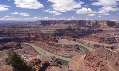 Dead Horse Point, high above the Colorado River. |
 Part of the group at the Dead Horse Point Overlook, with the Colorado River far below snaking its way through a series of meanders and goosenecks as it makes its way to the confluence with the Green River. |
|
Front Row: Kathleen, Bruce Middle Row: Eileen, Sharon, Jenni, Michael Back Row: Lisa, Emie, Chuck At 527 square miles, Canyonlands is a huge track of land and dwarfs Arches 120 square miles. The Island in the Sky district at the park’s north end is easily the most accessible of the three districts (the other two being The Needles and The Maze) and is a vast mile-high mesa bordered on the east by the Colorado River and on the west by the Green River. |
 The view from Mesa Arch. 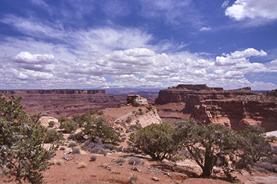 Approach to Grand View Point Overlook. |
The confluence of these two great rivers forms the southern terminus of the Island in the Sky. Our work is cut out for us, as we have only a few short hours to attempt to soak up and appreciate one of the most scenic tracks of land on the Colorado Plateau. We start with a visit to the park’s Visitor Center, where we watch the short video introduction to Canyonlands. We will then drive all the roads the park service has made available to us, check out all of the scenic overlooks, and hike as many of the short trails as we can, while – as our friend Rudy puts it – we are still burning serious daylight. |
 White Rim Road |
 The view from Grand View Point Overlook. |
|
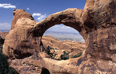
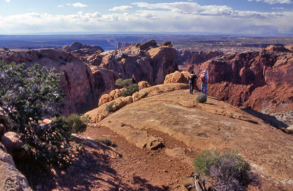
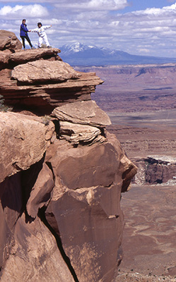
We start with a short, half-mile loop hike out to Mesa Arch, perched spectacularly at the edge of a 500-foot sheer cliff, dropping into Buck Canyon. Through Mesa Arch we get a good view of White Rim country and can also see the snow-capped La Sal Mountains far to the northeast near Arches. You have to look carefully to spot Washer Woman Arch in the distance to the left through Mesa Arch. Sharon strikes up a conversation with a fellow rock climber (they can spot one another almost instantly), and we persuade him to take the one complete group picture of the trip (almost complete, since we are missing Loyd), as we strike a majestic pose in front of Mesa Arch. |
|
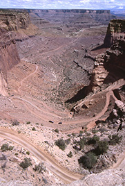
We next make our way south to the end of the scenic drive at Grand View Point Overlook, where we also catch an afternoon ranger talk on the geology of Canyonlands. Without question the grandest overlook in Canyonlands, Grand View Point offers a spectacular panoramic view of hundreds of square miles of Canyonlands and surrounding areas. We spot several jeeps and trucks below us, as they wind their way up the steep and narrow White Rim Road, a 100-mile long 4WD road built by uranium prospectors after World War II. The final scene in the movie Thelma & Louise was shot here, as the heroines plunge over the edge, believing they had at last found the Grand Canyon. |
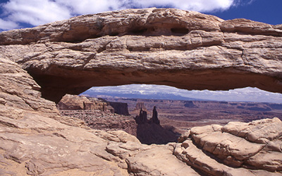 Mesa Arch 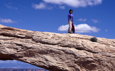 Eileen atop Mesa Arch. |
|
“From Grand View Point ... the big jump-off is only a few steps south and beyond that edge lies another world, far away. Down below is the White Rim; deeper still is the gorge of the Colorado; off to the right is the defile of the Green River; looking past Junction Butte we can see the barren point where the two rivers join to begin the wild race through Cataract Canyon; beyond the confluence lies the wilderness of the Needles country, known to only a few cowboys and uranium prospectors; on the west side of the junction is another labyrinth of canyons, pinnacles, and fins of naked stone, known to even fewer, closer than anything else in the forty-eight United States to being genuine terra incognito – The Maze. Far beyond these hundreds of square miles of desiccated tableland rise the sheer walls of further great mesas comparable in size and elevation to the one we stand on; and beyond the mesas are the mountains – the Abajos and Elk Ridge forty miles south, the La Sals and Tukuhnikivats forty miles east, the Henrys fifty miles southwest.” Edward Abbey, Desert Solitaire The rocky ledges around the White Rim, a mammoth sandstone bench 1,200 feet below our mesa, are a favorite hang out for Canyonlands’ desert bighorn sheep. However, we are not fortunate enough to spot any today, so we make our way back north on the park road, turn northwest at the junction, and head for Whale Rock. This is a relatively easy hike of one-mile round trip, with an elevation gain of about 300 feet. With a bit of imagination, this huge rocky outcrop does somewhat resemble an old whale, who must have beached himself millions of years ago, when this area was covered by the sea, and turned into solid rock. Apparently, it must have also reminded Lisa of Ayers Rock in Australia, since it prompted her to recall a trip there several years ago, as she celebrated a milestone birthday with friends (sorry, but I can’t say which milestone). The handrails bolted into solid rock along the steeper sections of the trail remind us of Picacho Peak, which Sharon and I had just hiked days before. We have to laugh at an earlier warning about not kicking the rock cairns. |
|
Not sure who would want to kick them anyway, but the park service has permanently secured these babies in place with concrete. Anyone foolish enough to try had better have steel-toed boots, or suffer a few broken toes. From the top, we enjoy the 360-degree panoramic view and get another opportunity to photograph a Flying Rudy, as he takes his famous stance on top of Whale Rock. |
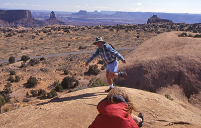 The famous Flying Rudy atop Whale Rock. |
 Hikers peering into Upheaval Dome. |
 Upheaval Dome |
Our last stop at Canyonlands is Upheaval Dome, just up the road from Whale Rock. The road terminates at this point, so we have no other choice but to get out of our vehicles and walk, if we want to see this odd geological phenomenon. The trail gradually climbs for the entire half-mile to the first viewpoint, located on an exposed slickrock outcrop. A few in our group hike further out to a second viewpoint for a better look at the dome. |
 Siesta time in Canyonlands. |
We read the interpretive display explaining the interesting geology of the area, after which Rudy becomes bored and attempts to balance two dimes on the slickrock (he actually succeeds after numerous attempts!), and several of the women decide to stretch out on the warm, smooth rock like lethargic, leggy lizards and take a short sunbath. This is one of those pictures that simply begs to be taken. |
|
Upheaval Dome, despite the name, is actually a two-mile diameter, 1,500-foot deep crater, surrounded by a ring of raised rock with unusually buckled and twisted strata. At its center lies a large bluish-grey mass of highly distorted and stressed rock. Its origin has been highly debated among geologists for years, and one was quoted many years ago as saying Upheaval Dome was the most remarkable geological feature yet discovered in Utah. The most prevalent theory promotes the concept of vast, slow moving underground salt deposits, many thousands of feet thick, pushing the overlying layers of sandstone upwards, buckling and distorting them in the process. |
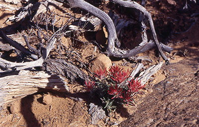 Indian Paintbrush adds a bit of color to a harsh environment. |
This certainly sounds plausible, given the origins of Salt Valley back in Arches National Park. A more recent theory suggests a meteor impact, obviously more exotic and exciting. I have a personal theory that over the years all of the beautiful women who have stopped here to lay on the rock and sunbathe have caused the rock to overheat and melt into its present day form. |
|
Regrettably, we say goodbye to Canyonlands and make the long drive back to Moab, where we have dinner and ice-cold beer waiting for us at the Moab Micro Brewery. We still have plenty of daylight to burn and more things we could see along the way, but it has been a long day of hiking and adventuring, we are all a bit tired, and the brewery beckons us. Most of us head directly for the microbrewery, while several of the women decide to stop off and take a quick shower at one of the local bike shops in Moab. |
|
Most of us guys just tough it out without showers for the duration of the trip (phew!), but all of the women wind up going into Moab for almost nightly showers. We enjoy dinner and cold beer, while several of the women opt for wine, and wait for the clean trio to return from their shower. It turns out to be a long wait, and some of the others leave, before our last holdouts arrive for dinner. After dinner, we make the long drive back to camp. |
 Eileen and Sharon on top of Mesa Arch. |
|
The tour of Canyonlands was originally scheduled for our last full day, Monday, however we changed the schedule around to accommodate the Fiery Furnace tour in Arches on Monday. Kathleen had talked to one of the rangers earlier about the tour, and it sounded like too good of an opportunity to pass up. The only problem was having to divide our group into separate tours, since we were too large to go as one group. Half of us would go on the morning tour, while the other half would do the afternoon tour. Because too many people became lost over the years, with a few actually dying in the searing summer heat, while hiking this largely trail-less area with its intricate maze of narrow gullies and canyons, the Park Service initiated a ranger-guided tour several years ago. The name Fiery Furnace is quite fitting during the summer months, as temperatures in Arches can easily soar to 110 degrees and above. An eight-dollar activity fee per person is collected, as part of a new fee demonstration pilot program enacted by Congress in 1996. |
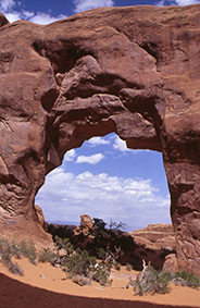
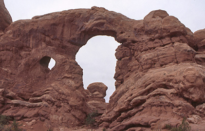
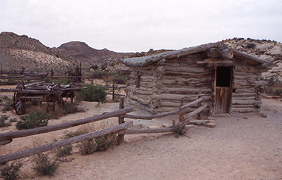 Wolfe Ranch, built in 1888. Our first stop of the morning is Park Avenue, aptly named after New York City’s famous street. We start at the south end and descend down a long series of stair-steps carved into the rock and leading to the slickrock dry wash on the canyon floor. The towering canyon walls and sandstone spires with names like Courthouse Towers, Tower of Babel, Three Gossips, and The Organ almost seem like natural “skyscrapers” and apparently reminded early visitors from the NYC area of the man-made concrete canyons they were used to hiking daily. Personally, I prefer Arches skyscrapers. We head back north to the Windows Section, where we take the short one-mile loop hike out to and around the North and South Window, two massive arches separated by an equally massive pillar of sandstone, and Turret Arch. |
|
|
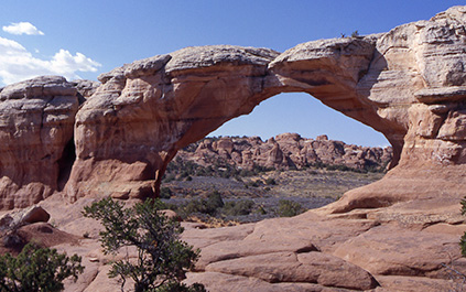
| Turret Arch, and Delicate Arch with La Sal Mountains in the background. | |
|
Doubling back on the Windows Section road, we stop off for a short hike out to the very impressive Double Arch, two massive arch spans joined together at one end, and then check out Cove Arch, Ham Rock, and the Garden of Eden, before continuing north to Wolfe Ranch Road, our entry point to Delicate Arch. |
|
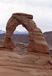
A rugged and weathered log cabin, root cellar, and corral near the Delicate Arch Trailhead are all that remains today of Wolfe Ranch, built by Civil War veteran John Wesley Wolfe in 1888. We leave the old ranch behind and cross a small suspension bridge over Salt Wash, bound for Delicate Arch. We have 1.5 miles of trail to hike and 480 feet of elevation and gravity to overcome, before we can cast our eager eyes upon the most famous arch in the world, the quintessential symbol of Arches National Park and now Utah’s state symbol, featured on license plates, post cards, posters, coffee table books, and T-shirts (I confess that I am now the proud owner of a Delicate Arch T-shirt) throughout the world. |
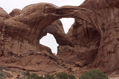 Double Arch  North and South Windows |
 Ute Indian petroglyph panel. |
Shortly after crossing the bridge, a short spur trail to the left takes the hiker to a small petroglyph panel, courtesy of the local Ute Indians. The first half mile of trail is relatively level and well- defined, as it winds through typical desert canyon country, before depositing us at the base of a mile of sharply ascending slickrock that we must conquer before being rewarded with the grand view of Delicate Arch. |
|
Onward and ever upward we ascend, with only an occasional rock cairn, some hardly recognizable, to mark our path. In the absence of rock cairns, we sometimes use human cairns in the distance to align ourselves with. Sounds a bit strange, but it works – as long as the distant human knows roughly where he is going. Stopping occasionally to admire the view and catch our breath, we continue on a seemingly endless path of slickrock that appears to be getting steeper and steeper, as we close in on our target. The trail levels off for a while, as it moves through a wash, before climbing once again to a rock ledge blasted out of a cliff face, as evidenced by the numerous bore holes in the rock. We pick up our pace, as we follow the narrow ledge for a couple of hundred yards, before reaching the edge of the cliff face. Emerging from the ledge and cliff, we are suddenly blasted by heavy winds, as we see the arch for the first time. Delicate Arch, with its 33 by 45-foot opening, sits perched precariously on the edge of a small canyon with the snowcapped La Sal Mountains as a backdrop. This is the classic picture every serious photographer wants to capture, and shutters are going off all around us, as everyone attempts to preserve this magical moment, this small slice of geological time. Sharon and Eileen catch up with Bruce and me, and we take turns taking pictures of one another in front of the arch. A nearby photographer is trying to find the perfect place to set up his tripod. We brave the wind for a few more minutes and decide to head back. We have a 2:00 PM appointment for the Fiery Furnace tour and waste no time descending the slickrock trail back to the trailhead, since we are burning serious daylight now. We arrive at the Fiery Furnace Trailhead with time to spare and check in with our tour guide, Shaun, a young and energetic volunteer Park Service Intern. Shaun checks over our permits and footwear (Sam has to defend his preference for sandals at this point) and explains the rules of the tour. |
 Jenni, Sam, and Kathleen mugging for the camera. |
Besides staying together as a group, bringing plenty of water, and taking only pictures and leaving only footprints, the big rule is knowing where not to leave those footprints. By now we have all heard the story about cryptobiotic crust more times than we care to admit, but it is a story worth repeating, since it is so critical to the future of the desert and canyon country. |
|
Covering almost 75% of the total ground surface of the vast 130,000 square-mile Colorado Plateau, cryptobiotic soil crust provides a protected environment of stabile soil cover, nutrients, and vital moisture for the sparse vegetation struggling to exist is this harsh and often hostile environment. Consisting of an eclectic mix of cyanobacteria, lichens, algae, fungi, mosses, and liverworts, this strange looking lumpy, knobby textured, and brittle soil crust helps stabilize the fragile soil of the desert, preventing soil erosion. This unlikely combination produces billions of microscopic sheaths that send tiny tendrils in all directions throughout the top few millimeters of soil, literally cementing the individual sand grains and soil particles together into one continuous crust. Absolutely critical to moisture retention and plant survival, this lifeless looking crust can expand up to ten times its size, swollen with moisture, after even the briefest of desert rain showers. The biggest problem now is its rapidly expanding rate of destruction in the face of increased human activity in the desert. Careless hikers, hunters, mountain bikers, ATV riders, and off road vehicle drivers can destroy in seconds what nature took centuries to build. In the drier areas, it can take up to 250 years for the cryptobiotic soil crust to repair itself, once destroyed by careless human activity. 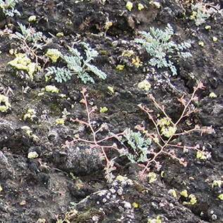 cryptobiotic soil crust at Hovenweep National Monument [picture by Ted Tenny, 2010] “Little did I know what my children would allow me to see: Lilliputian landscapes often overlooked by educated adults seeking the Big Picture ... I realized how much time adults spend scanning the land for picturesque panoramas and scenic overlooks. While the kids were on their hands and knees engaged in what was immediately before them, we adults traveled by abstraction.” Ranger Shaun leads the way, and we follow him, single file, into the bowels of the Fiery Furnace, not knowing where or when we would emerge. Lucky for us, it is a somewhat breezy and overcast afternoon and the name Fiery Furnace seems totally inappropriate at the moment. Later on, the sun would emerge, layers would come off, and we would start to sweat a bit, and begin to appreciate just how fitting the name would be a couple of months from now. We drop down through a maze of boulders and emerge onto a wide and sandy wash, where we are told to stay in the center to avoid the crypto crust that builds inward from the sides of the wash. There are no marked or distinct trails here, for most of the way, and it is easy to see how people could quickly become lost or disoriented without a knowledgeable guide to lead the way. |
 Descending into the Fiery Furnace. |
 Deeper into the Fiery Furnace, with the snow-capped La Sals in the background. |
|
Onward we travel through narrow gullies and narrower sandstone canyons, just on the verge of being classified as slot canyons, where one can literally reach out and touch both canyon walls. Massive and towering fins, spires, pinnacles, ridges, and canyon walls surround us, as we continue probing deeper and deeper into this maze-like labyrinth of canyon upon canyon, some with colorful names like Raven Canyon and Juniper Canyon. At one point, we cross under a natural bridge and stop in a small box canyon, where some of the more nimble and adventurous in the group crawl on hands and knees through a couple of small arches perched on a narrow ledge above us. A cold wind whips through the canyon, swirling stinging sand particles in our faces, and forcing some of us to start adding another layer or two. It is almost like a surreal scene out of The Lost World. We traverse up and over large expanses of slickrock, through yet more narrow, deeply shaded canyons, where the sun’s rays probably only penetrate for an hour or two a day. We discover small, water-filled potholes in some of the slickrock wash areas we travel through. We stop for a break in a narrow, sandy-floored canyon, where Shaun points out a cluster of poison oak plants growing in a moist wash area. He then shows us a low and narrow ascending passageway through the rock and asks for volunteers to follow him through. Almost without exception – putting full faith in our guide now – we remove our packs and park them up against the canyon wall in a neat row and then crawl on hands and knees through the deep and cool sand, as we penetrate the long and dark passageway, emerging into a slot-like canyon on the other end. We then have to jump across a narrow slot onto a rock ledge and follow that back out into the main canyon. We brush off the sand, swing on our daypacks, get a quick drink of cool water, and follow our trusty guide to the next destination. We eventually come to a slickrock ledge, separated from the canyon wall by a deep and narrow chasm that requires us to straddle it – spread eagle and leaning into the wall with outspread hands, while we find a foothold across the chasm and gradually and carefully work our way back down to the canyon floor. A couple in our group with two young children find this a real challenge, but we manage with a brigade-like maneuver that safely passes the kids through. I imagine they will be talking about their experiences on this trip for a long, long time.
|
 Lisa and Emie in a real cliffhanger. |
We ascend yet another large expanse of cool slickrock and take a break, as our guide asks us to locate a couple of arches in the immediate area. It isn’t too long before someone points out a large and rather obvious arch directly overhead, almost black now against an expanse of bright blue sky. So surprised were the original discoverers of this arch not too many years ago, that they aptly named it Surprise Arch. Despite plenty of hints, no one can seem to locate the second arch, not obvious to the eye at all. Shaun points out a pork chop shaped chunk of rock attached to the canyon wall in front of us. This is an arch, we all wonder to ourselves? You literally have to plaster your face tightly up against the cool wall and look straight up into the rock, before finally spotting a narrow slice of light between the two surfaces. Because it is slightly over three feet in length, regardless of the height or width, it meets the official requirements for an arch. New arches are being discovered every year in Arches National Park – 2,200 now and counting. |
|
We have to straddle one or two more ledges and navigate through a few more really tight passageways, similar to Fat Man’s Pass in South Mountain, before we are graduates of the Fiery Furnace tour. We traverse one final large expanse of slickrock, before descending back down through a narrow series of switchbacks and emerging once again onto the canyon floor. Jenni gently takes a frightened little girl’s hand and carefully guides her down the trail to safety, earning her parents grateful thanks. Before we know it, we are all safely back at the trailhead and out in the bright sunshine and blue skies of Utah. It has been quite an experience and will certainly stand out as one of the highlights of the 2004 trip to Arches and Canyonlands National Parks for most of us. Thanks again, Kathleen, for suggesting the Fiery Furnace tour. As we make the drive back to our campground, we are a bit saddened knowing that this is the last full day of the trip for most of us. On our arrival at camp, we discover that several tents have blown over during the day. Several had blown down the day before, with Sharon’s tent wrapped around a tree, and Lisa’s taking water damage from the rain on Saturday night. I discover my own tent lying on its side, the contents inside now a jumbled mess, with one broken lantern mantle. We make any necessary repairs and then prepare our last dinner at Arches. After dinner, some of us take in one final ranger talk on the symbiosis of the flora and fauna of Arches. We then take advantage of the absence of winds tonight and gather around the grill at Kathleen and Emie’s campsite for our first real campfire of the trip. Lisa has several bags of mesquite wood that she wants to get rid of, so we have a nice, roaring fire going in short order – not quite as good as a large campfire on the ground, but good enough for now. |
|
We also have a newcomer in our group for tonight: Janie, a coordinator from Outward Bound, who Kathleen and Emie had met and befriended earlier in the day on the Delicate Arch hike. She needed a place to sleep for the night, and we had the space for her. It is almost midnight before we finally break up and head to our tents for our last night at Arches. |
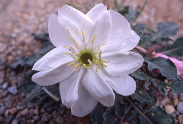 Oenothera caespitosa - Stemless Primrose |
|
Tuesday morning dawns cool and clear. We fix breakfasts and slowly start to break down camp and pack away our gear. We take a few last group pictures, get in a few final hugs and handshakes, and bid one another fond farewell and a safe passage back home. Rudy rolled out of camp at 3:00 AM this morning on his way to Colorado. With the exception of Michael, Lisa, and myself, everyone else is heading back to Arizona today. We three are adding a couple of extra days to the trip, with a search for Lisa’s Red Dragon petroglyph near the San Rafael River northwest of Arches and a side trip to Colorado to see Colorado and the Black Canyon of the Gunnison National Monuments. We make a last minute map check and reluctantly leave Arches and good friends behind, but take lasting memories of great times in Utah with us. CONTRIBUTIONS FROM FELLOW ARCHES ADVENTURERS: Sharon As for Arches, the best part was the Fiery Furnace and doing Delicate Arch. I loved them both. The only thing I would consider not doing is Canyonlands. With the 8-9 hour drive up there, I wasn’t in the mood for more driving, although it was scenic. Just a thought. KathleenThe trip was wonderful. Arches National Park rivals the Grand Canyon in splendor, and the range of activities exceeds the GC. The happenstance that took us to Canyonlands on day 2, splitting our time at Arches to day 1 and day 3, actually was a wonderful way to keep us from growing numb to the beauty of the arches. It is so overwhelmingly lovely, that the break afforded by the change of scenery in the Canyonlands let us marvel equally on day 3 at all the fantastic sights at Aches, as we did on day one. I would add that the (reservations only) trip through Arches Fiery Furnace is a must do, especially if you bring children, say 8 and up. They would love the crawling, climbing, exploring antics that are part of this tour, and makes this a memorable experience. These reservations are not always easy to get though ... so stop in the ranger station first thing on your arrival to sign-up ... then go play! No individual fire rings were available in Devil’s Garden Campground, only grills, but the nightly ranger’s talks were entertaining. The Canyonlands scenery is totally different ... that of canyons rather than arches! Also there were fantastic vistas that rival the GC in grandeur ... with lots of hiking/biking opportunities that we had to forgo. Three days (plus travel-time) for sightseeing is a minimum for these two destinations, and about right, unless more extensive hiking/biking/backpacking adventures are desired. BruceI think my favorite part of the trip was the hike to Delicate Arch. Both the hike and the destination were memorable. The Fiery Furnace gets an honorable mention. On a social note, I really enjoyed the outing to the Moab brewpub. It was nice to sit down with everyone face-to-face for the only time on the trip! Lessons Learned: Be extremely careful when cooking in heavy wind! My Coleman 2-burner stove was very stable when it was set on the table in its “closed” position, but once it was opened, the vertical position of the lid and side flaps made for a surface very unstable in the wind. In fact, the wind was so strong that the stove blew off the table! Solution: the stove was moved to the ground, and a partial windbreak was fashioned using a big rock and an ice chest. LisaUtah has so many well-kept secrets, and Arches and Canyonlands are two of them. My favorite moments were at Delicate Arch, the Fiery Furnace, the Dead Horse Point State Park overlook (although I don’t care for the name), the Whale Rock at Canyonlands, and just hanging around the campfire on the last evening. I was also thrilled that I didn’t wake up when Rudy left at 3 AM, since I was only 20 feet away! It was nice to share these memories and many other discoveries with such a great group of people. It was great hiking with everyone, and I’m looking forward to the next trip. See you all the next time. EmieThat was a fantastic trip! Thank you for all you have done to prepare us, and for making our stay fun. It was a wonderful experience for us all. Arches is so beautiful, which makes it difficult to leave. Thank you to all of you for being such great sports and good friends in camp and on the trails. It made the hikes easier and fun. This is among the most FUN, chemistry-matched groups I have ever been out with on trips, a little roughing it, but not really! From the beginning we seemed to have hit it off. If you recall, I just talked to Kathleen the day before the trip and met her that Friday of our departure. I had so much fun with everyone being so gracious and accommodating and just plain helpful. Being new to the group and to these kinds of activities, you were all so kind to this amateur hiker! The organization/preparation of the trip was excellent. You deserve the credit for that! It was well planned; activities and trips were well balanced. Even the trip up there was delightful, with nice spots for sightseeing stops. The route was just beautiful! The rescheduled canyonlands outing in the middle of the two days in Arches worked just right. I think this is something you want to consider for future trips, since this was a great break from looking at arches day after day. The hikes within Arches worked great – you started with the fairly easy, short ones and then the more difficult ones later in the day. The Fiery Furnace hike is something you may want to plan ahead of time for any future groups, as it is something not to miss! The combination of lead-in hikes, where you clearly showed everyone where to go and suggested what places to cover, gave us the opportunity to see almost all of what Arches National Park had to offer. We were so fortunate with the Devil’s Garden/Double O Arch hike that there was no major disaster. I think it helped that the group was together most of the time. Except for Lisa’s injury, it was a great trip. I think the weather helped us enjoy that day (no rain!). But I also think that the free time we had to explore among ourselves gave us the feeling of not being so “cooped up” with the group all the time. This would have been extra helpful if the group chemistry was not as good as what we enjoyed. So, lesson is, balance of keeping a tight leash, but giving the slack in between or after trips (or even during trips) for folks to feel that they are not in an army drill exercise. I guess this was a good time to plan to be at Arches/Canyonlands, with just one night of blustering wind/rain, so I think we lucked out with fairly good travel and hiking weather. I just wish that we had more opportunity to cook as a group in the campground and share stories. The last night was fun! Bill and Fran were very gracious to have us over at their trailer for dinner that windy night! I would also wish for the same free-spirited, good-natured folks on future hikes and camping trips. It was truly an experience, and the place was just awesome. Thanks for all of your hard work. SamHey Chuck. You did a good job organizing this trip. I loved every bit of it. BillFran and I both enjoyed hiking and chatting with all of you. Thanks again, Chuck, for lining the whole thing up. I would go back in a minute. |
 Top of Page
Arizona Trailblazers Hiking Club, Phoenix, Arizona
Comments? Send them to the AZHC .
updated August 28, 2018