Outdoor Links
Hike Arizona
Trip Planning Guide
Trip Report Index
Calendar of Events
Library
|
Carr Lake Loop Day Hike Mogollon Rim August 1, 2015 by Bill Zimmermann |
|
 Deirdre, Sana, Rudy, Dave, Biljana, Carol, Bill, Alan, Christina, Michael, Jim |
 We met a horned toad on the trail. |
Ten hikers left the valley at 6:05. We picked up Rudy in Payson and were on the trail at 8:15. A small patch of blue sky accompanied us on the first part of the hike as we passed an Aspen grove. The out front hikers blew past the onion patch at “GO” that Bill was looking for. Next time. Soon we were hiking under cloudy skies. At “T412” Bill offered an unplanned bushwhack short-cut to “N1”. No takers. We continued on trail. As we passed “N1”, Pines gave way to Spruce and Fir along with sprinkling of Oaks. |
 Fallen tree is a minor obstacle. |
 Is this the way to Carr Lake? |
 Dense vegetation along the trail. |
|
At about 10:45 near “N2” the sun came out as if on queue as we left the trail at “N4” for photo opportunities at Carr Lake. No water skiers. No kayakers. Just nature at its best. After a short break on a log with seating for eleven we were headed toward an intersection with the trail at “N5”. Clouds returned. However, as we left the trail at ”ZZ4” we were again treated with sun, blue skies, and fluffy white clouds. Our bushwhack toward the point “PT2” was uneventful except for Dave’s tumble on some downed barbed wire. |
 Biljana and Sana |
 Oops! |
|
Views from the point were awesome. Did I say awesome? The rock at the very point was wide and flat. With picture taking completed we headed for our rendezvous with the General Cook Trail #140 at “ZZ5”. |
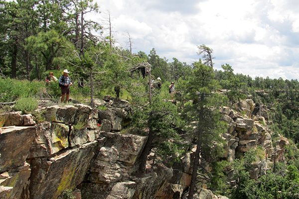 The Mogollon Rim is an escarpment that runs halfway across Arizona. |
 Great view, when you can see through the trees. |
 Bill and Christina enjoy the view. [photo by Carol] |
 Rudy finds a way. |
 Carol gets through the Mullein. |
 Look, but don’t touch. |
|
Shortly after “Z411”, a light drizzle and thunder stayed with as we hiked back to the vehicles. We caught fleeting glimpse of two elk crossing our path. After a late lunch in Payson we headed back to the Valley. |
|
Supplemental Report by Jim Buyens |
|||||||||||||||||||||||||||||||||||||||||||||||||
|
Thanks, everyone, for being on the Carr Lake hike and especially to you, Bill, for leading it. I sincerely hope everyone had a great time. Somehow I developed some leg and back pain toward the end of the hike and that slowed me down some. I think either I didn’t drink enough water or I twisted something scrambling off-trail. I’m feeling much better today, though, so I’m sure it was nothing serious. Jim |
|||||||||||||||||||||||||||||||||||||||||||||||||
|

|
||||||||||||||||||||||||||||||||||||||||||||||||
| → More pictures and commentary, by Jim. | |||||||||||||||||||||||||||||||||||||||||||||||||
 Top of Page
Arizona Trailblazers Hiking Club, Phoenix, Arizona
Comments? Send them to the AZHC .
updated July 3, 2019