Outdoor Links
Hike Arizona
Trip Planning Guide
Trip Report Index
Calendar of Events
Library
|
Dirtyneck Canyon Exploratory Hike Mogollon Rim May 31, 2014 by Bill Zimmermann |
|
 Thirteen Trailblazers assemble for a hike at Dirtyneck Trailhead. [photo by Dave] Chris, Andy, Michael, Nicole, Bill, Arturo, George, Ted, Bruce, Dan, Jeanne, Rudy, Dave |
|
Eleven hikers left the valley to escape the heat. We joined Rudy in Payson and George in Pine. We parked our vehicles on the east side of SR87 near milepost 285. With introductions and group pictures completed, we were ready to hike shortly after 9:00 AM. First up: crossing the barbwire fence: |
 Andy holds the barbed wires apart for Arturo. |
|
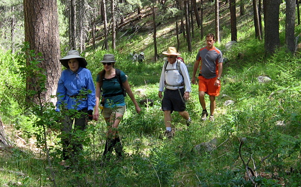
The weather was sunny with a sprinkling of clouds. All thirteen hiked together until “04”. At that point we parted. Nine joined me for the longer hike. |
 Will we look this good on our way back? [photo by Ted] Rudy, George, Michael, Nicole, Chris, Bruce, Dan, Bill, Arturo, Andy |
 Ferns and brush line our route out of the canyon. |
 It’s a steep climb up the slope. |
|
First up was the “101 Spring”. Unlike the hike up to this point, the spring canyon was thick with vegetation. We went high on the north side working our way up and out to the intersection with FR147 at “RX1”. |
 The going gets easier as we approach the road ... |
 Then it’s downhill, rather steeply. |
 Arturo makes it under the fence. |
We picked our way toward Poverty Spring, dodging some sections of thick new growth ponderosa pine. Arriving at the spring we found it dry. You think the name poverty was a clue? Poverty Draw was wide, spacious, with tall green grass and a dirt road. It looked exciting if you were a cow and up for grazing. |
 Nicole finds a comfortable resting place. |
 Rudy finds a remarkable open-end wrench. |
 We enjoyed a lovely shaded picnic area. |
 Ten hikers on a grand Mogollon Rim adventure! Bill, Rudy, Nicole, Andy, Chris, Dan, Michael, George, Bruce, Arturo |
 ... Then the stream disappears underground, as Andy observes. |

Nicole gets under the fence safely.
At “LR” we left the road. Soon we broke for lunch at “L” under a shade tree overlooking a water-filled creek. The site came with an outdoor toilet seat. After lunch we continued down the creek. As we got closer to “9” the water disappeared or went underground. Bill overshot the easier way out, a gradual draw near “09”. Our path took a steeper up, then a down, then another up on our way to “RX8”. We bailed on waypoint “RX2”. |
 Graceful arch, or obstacle course? |
 Bill, you’ve done it again! |
At “ZZ1” we had a mutiny that led to a change in the route plan. Group pressure chose for the easier crossing of Snake Draw. The “15 to 16” route will have to wait until another adventure. We reached the vehicles at 4:00. After a cold drink and change of shoes, Dan left for more hiking up near Flagstaff. Famished, the rest of us headed to Pine for some food and drink ... way too hungry and tired for more pictures. |
|
About 10.5 miles 1600 feet (original plan 8.5 miles 1200 feet). |
|
|
Supplemental Report by Ted Tenny |
|
||
|
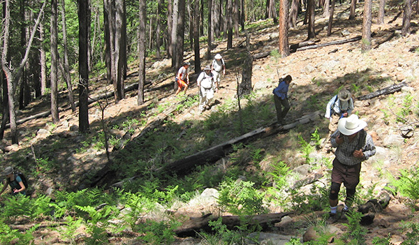
Shortly after starting the hike we thought Bill was going to send Jeanne, Dave and me to the side canyon shown on his map. But he kept the group together for the first mile or so, then sent the three of us upstream in Dirtyneck Canyon while everybody else continued on ahead in a side canyon. |
|||
 Bill’s hikers head out for parts unknown. |
|
|
Dirtyneck Canyon gets its name from dirt that appears along meanders of the stream near the highway. It has a trail of sorts, though the trail disappears in places. Jeanne, Dave, and Ted hiked upstream, on the trail when we could find it. Many downed trees had fallen across the stream and across the trail, so we went over, under, or around them. After about a mile we came to a clearing where the canyon divides. Here we stopped for a snack and to re-check Bill’s map before going on. |
|
 Ted, Jeanne, and Dave in Dirtyneck Canyon. |
|
 Don’t forget to duck. |
 Quiet reflective pool in the canyon. |
 Dave finds the trail beside a pleasant stream. |
 Jeanne approaches the clearing. |
 Ferns and grasses are watered by the stream. |
|
|
The trail heads left from the clearing, along the side of the stream. It’s a smooth, easy grade that looks as if it might have been a road, although there are no signs of traffic. Then we see a real road, with a van parked beside it. A young couple are enjoying their excursion to a remote area of the Mogollon Rim. We meet them again on our way down. Although we would like to explore Bill’s side canyon on our return trip, we manage to miss the junction. Still, it’s a pleasant hike back through the canyon. A deer walked in the stream a short time before us, leaving fresh footprints in the bottom of the streambed. Wildflowers, ferns, and a refreshing breeze cheer us along the way. |
 A deer got there before we did. |
|
 Capsella bursa-pastoris - Shepherd’s Purse |
 Thermopsis pinetorum - Spreadfruit Goldenbanner |
 Wonder what critters may live in this cave near the trailhead? |
|
 Let’s see that cave more closely. [photo by Dave] |
 Jeanne and Ted troop the trail. [photo by Dave] |
 The dirty neck of the canyon. |
|
|
After the hike Dave shared some cold beer with us. We decided to just buzz on back instead of stopping to eat along the way. Our drive home was uneventful until we crossed the last valley of the Mazatzals. Then we saw smoke off to the left – a fire. There were Forest Service personell along the highway. A big jet plane was circling around and flying low, even though there’s no airport nearby. As we watched, the plane swooped down and dropped fire retardent over the area. Then we saw it flying southwest, back to its base. |
 Fire-fighting jet. [photo by Jeanne] |
|
Thanks to Bill for organizing and leading an enjoyable hike! |
|
 Top of Page
Arizona Trailblazers Hiking Club, Phoenix, Arizona
Comments? Send them to the AZHC .
updated September 15, 2018