Outdoor Links
Hike Arizona
Trip Planning Guide
Trip Report Index
Calendar of Events
Library
Payson
July 27, 2013
by Scott Green
|
The Bear Hunt
(Leader) We’re going on a bear hunt! (Group) We’re going on a bear hunt! We’re gonna catch a big one! We’re gonna catch a big one! I’m not afraid! I’m not afraid! Are you? Are you? Not me! Not me. |
|
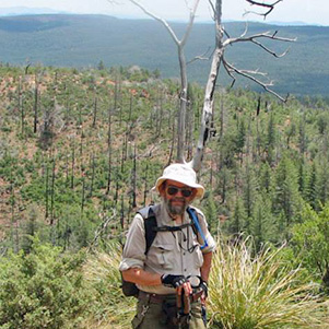
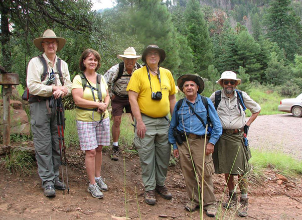 Scott, Terri, Rudy, Michael, Arturo, Jim. |
|
The above children’s song could have easily been the hike’s theme song as we traveled along the combo-segment of the Arizona Trail and Highline National Recreation Trail, starting from Washington Park Trailhead to Geronimo Trailhead. But I’m getting ahead of myself. Five of us met in Fountain Hills and took two cars to help ensure a comfortable ride for all. It was great to be joined by a mix of recent club members and members from previous years. Per the plan, we stopped in Payson for a pit-stop and to pick up Rudy, who graciously drove his truck which greatly helped in the shuttle between the trailheads. The three vehicles headed north toward Pine, but before reaching town turned to the east on Control Road toward Geronimo Trailhead. After crossing a bridge over the West Weber Creek, which looked to have recent high water, we parked Rudy’s truck at the trailhead and traveled back to Control Road and headed east to the turn off for Washington Park. Passing through the summer home residential area, we followed the signs to the trailhead parking. The road paralleled the East Verde River, where car campers had set up for the weekend to enjoy the sound of moving water and periodic rain. |
 The trail has a lot of ups and downs. |
 Tiny waterfall is fed by recent rains. |
|
Washington Park Trailheads is the entrance for three trails. It provides access to the East and West routes of the Highline Trail and the North route of the combo Col. Devin Trail and Arizona Trail up the Rim two miles toward the General Springs Cabin. Also along the Col. Devin Trail is the South end of the Railroad Tunnel Trail, which allows a visit to the uncompleted railroad tunnel entrance. |
 The Rim Country is my home. |
As for the day’s weather; it was Deja Vu all over again, just like last weekend near Flagstaff. The previous night’s showers created a slightly muddy trail with high Arizona humidity and warm temperatures all during the hike. We perversely “glowed” throughout the hike as our body tried to trigger a cooling event using evaporation which was never quite sufficient. |
|
Fortunately, there was the benefit of cloud cover most of the day, and since the rain clouds and associated thunder stayed at the top of the rim while we were slightly below, we experienced less than a quarter mile of medium rain later in the afternoon. |
|
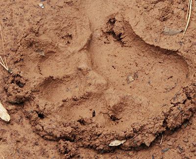
After a group picture of us looking our best at the Washington Park Trailhead, we headed to the west toward Geronimo Trailhead. The trail can be described as up, down, up, down, up, down, repeat. What was fun to find at most of the dips was running water in the steam beds which supported thorny bushes of blackberries of various stages of ripeness. Some were green and red with the sweetest being a deep black color. These were looked upon as nature’s reward for us reaching each milestone. Speaking of black, and in reference to the above bear children’s song, along a few stretches of muddy trail, the keen eyes of the hikers found black bear front and hind foot prints. The indentations and clean lines were obviously made that morning. Some showed the claws while other prints showed the paw pads both of which were of respectable size. |
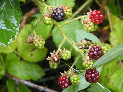 Berry, Berry Delicious!  Really, this is more than I can bear. |
|
Fortunately the prints were leading toward us, which meant we had already crossed paths some distance behind. We also saw, on the other side of a burn area turned meadow, a small heard of elk who joined into a game of stare and blink-first with us. |
 All Arturo needs is a steering wheel. |
 Jim doesn’t have horns – it’s just a tree. |
|
Although the map showed a distance between the trailheads of 10 miles, the leader kept repeating a total distance of 8.1 miles. After a few false the-end-must-be-just-over-the-hill experiences, we finally trekked down a long embankment past some of the Boy Scout Camp buildings into the parking lot where Rudy’s truck awaited. Actual GPS measured distance: 10.5 miles. |
 Majestic rock towers mark passage 27 of the Arizona Trail. |
 Water of life. |
|
Fortunately, we were all able to fit into the one vehicle and return together to Washington Park Trailhead. From there we split up into separate vehicles and returned to Payson via the paved and recently realigned Huston Mesa road where were traversed the East Verde River twice more at concrete crossings. Once in Payson we stopped for a Thai meal, ordering exotic dishes ranging from very mild to “911” spiciness. |
 The woods of home, Mogollon Rim style. |
|
Thanks to all who participated and helped make another great day for hiking. We should come back in 7 years when the Highline Trail is 150 years old. The Forest Service says the trail was first blazed in 1870. Pictures courtesy of Jim Buyens. → More pictures and commentary by Jim. |
 Top of Page
Arizona Trailblazers Hiking Club, Phoenix, Arizona
Comments? Send them to the AZHC .
updated May 23, 2018