Outdoor Links
Hike Arizona
Trip Planning Guide
Trip Report Index
Calendar of Events
Library
|
McFadden Horse Mountain Day Hike Sierra Ancha Wilderness September 29, 2012 by Andy Zaharchuk |
|
|
Before dawn on a clear, cool, late September morning, the group gathered at the designated meeting place. All who had signed up for the hike were present and accounted for except Mark, whom we would later meet at the trailhead. After signing in and sorting out who would drive and who would ride with whom, we headed out in three vehicles, with Jim B, Bill Z and myself driving. Our departure time was about 6:20 AM: sunrise. Heading east on US 60, we drove through Superior, Miami, and Claypool before stopping briefly at the WalMart for a quick pit stop. Soon thereafter we took AZ 188 from Miami north to AZ 288, and then on to the trailhead, located just before milepost 288 on AZ 288. The drive to the trailhead was uneventful. Although there was an unpaved section a few miles in length near the trailhead, the road was quite good the entire way. There was no need for high clearance or 4WD vehicles on this trip. The drive to the trailhead was about 90 miles in length, and took about two hours from our starting point in Gold Canyon, close to milepost 201 on US 60. |
 Wendy, Andy, Denise, Ed, Brian, Bill, Jim, Nicole, Dave, Mark, Ajay, Scott, Wayne. [photo by Bill] |
 Denise and Brian lead the big climb. [photo by Bill] 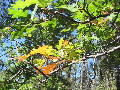 Colorful autumn leaves grace our passage. [photo by Bill] |
At the trailhead we met Mark, who had driven there from Payson. After brief greetings and introductions, all thirteen of us began the mountain ascent. The hike, from trailhead to the end of the trail, fell more or less into three parts. The first part involved getting up the mountain, much of the walk being on an old abandoned road. Because of the slope and elevation, this was the most difficult part of the entire hike, but all of us made it up to the top. Along the way up, we saw a tarantula half asleep on the trail, where we left him/her there napping. Later, along the trail, we saw a very colorful Greater Short-horned lizard (known as a horny toad to some, with actual scientific name Phrynosoma hernandesi in case anybody’s interested), a subspecies type that lives in coniferous forests at higher altitudes. |
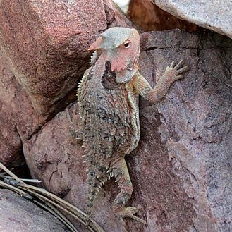 I really blend in around here. [photo by Wayne] After we had navigated our way along the mountaintop following the U-shaped route, we began the third part, descending into and climbing out of a shallow ravine. We then followed the trail northward along a ridge for about a mile as we approached the terminus. The last few hundred yards of the trail along the ridge was somewhat difficult to follow, and we spread out some, but it was clear which way to proceed, as we had the huge precipice just off to our right. Along the way here, we saw a few large piles of recently deposited bear scat, no more than a day or two old. We soon reached the end of the trail. There, while we enjoyed the panoramic views, we ate some snacks, drank some liquids, took some photos, and rested, before starting our return. While there, dark thunderclouds started to rapidly build up, so we high tailed south. |
 Wide-angle panorama northward from McFadden Horse Mountain. [by Wayne] |
 The view from the top. [photo by Bill]  The view from the top. [photo by Wayne] |
On the way back, we managed to stay ahead of the thunder and lightning and rain almost until we reached last part of the hike – the descent down the mountain. We caught some rain, first starting as a light drizzle and then it became heavier and cold, seemingly like hail that had just melted before it reached us. Fortunately, the rain soon stopped and for the last half mile or so, we were out of the rain and cold. Upon reaching the trailhead, we bade Mark goodbye and headed for home, stopping along the way in Superior for some Mexican food. All who participated came properly equipped and acted responsibly throughout the hike. No strays, no one lost, and no injuries, although both Dave and Wendy each stumbled once on loose rock and fell down upon the trail, both got up gamely and continued trekking. |
|
The individuals who participated in this good hike were: Bill Zimmermann, Ed Zorn, Ajay Kak, Scott Green, Jim Buyens, Dave French, Wayne Shimata, Nicole Richter, Wendy Kennedy, Brian Caldwell, Denise Caldwell, Mark Purcell and myself, Andy Zaharchuk. |
 Panorama northward from McFadden Horse Mountain. [photo by Bill] |
|
My thanks to all who participated on this hike and especially to Wayne and Bill for providing the photos for this trip report. It was a very good hike, one that had apparently not been done before by the Trailblazers. |
 Top of Page
Arizona Trailblazers Hiking Club, Phoenix, Arizona
Comments? Send them to the AZHC .
updated November 10, 2018