Outdoor Links
Hike Arizona
Trip Planning Guide
Trip Report Index
Calendar of Events
Library
Mogollon Rim
August 25, 2021
by Chuck Parsons
 Group. [photo by Eileen] |
| Eileen, Chuck, Joan, Jim, Diane, Monika, Rich, Billie, Neil |
|
Most of us arrive at Black Canyon Lake, one of the seven Rim Lakes on the Mogollon Rim, before 9:00 AM under clear and sunny skies. Unfortunately, the water level in Black Canyon is much lower than normal, with both the concrete launch ramp and the portable dry dock high and dry. This is almost an identical picture of last month’s Willow Springs Lake kayaking trip, where the lake level was a full ten feet below normal. |
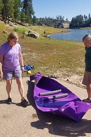 Joan and Jim look over their fold-up kayak. [photo by Billie] |
 Just a few more adjustments should do it. [photo by Billie] |
 H’mmm. What to do next? [photo by Joe] |
 Preparing to launch. [photo by Joe] |
|
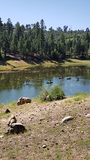
Despite all the rainfall from this summer’s active monsoon season, it’s doing very little to bring these Rim Lakes back to their normal water levels. Apparently, it’s going to take two or more years of an above-normal snow pack to accomplish that task. And whether we’ll actually see that happen is anyone’s guess. Considering the low lake level, a much smaller and weed-filled lake, and a muddy shoreline with the associated difficulty of getting in and out of our kayaks. Eileen proposes a hike around the lake instead. This was actually part of the original plan anyway—to kayak first and then hike around the lake for anyone interested. She had tried this a few years earlier, but was unable to find a good route completely around the lake. So Rich and I decide to forego kayaking for the day and join Eileen for some serious route-finding around Black Canyon Lake, while the other six in our group proceed with launching their kayaks. The time is now 9:45 AM, as we begin hiking and kayaking. |
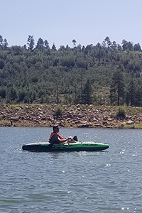
 Diane, Jim, Monika, and Joan on the lake. [photo by Billie] |
 Neil, Billie, and Jim are moving out. [photo by Joan] |
 Monika and Diane are checking out another area. [photo by Joan] |
 Chuck, Rich, and Eileen, high above the lake. [photo by Billie] |
 Neil. |
 Chuck, Eileen, and Rich. |
 Joan. |
| [photos by Billie] | ||
 A calm, mirror-like surface on the water. [photo by Billie] |
|
As Eileen, Rich and I slowly work our way around the lake, we keep our six kayakers in view for most of the way, as they work their way around the lake trying to keep us in view as well. The trail is fairly easy to find and navigate for the first mile or so, but as we get closer to the dam it becomes pretty obvious this is not a well-traveled trail by any means. Completely overgrown in some places, it virtually disappears or grows very faint in other places, requiring some good route-finding and dead-reckoning skills to keep forging ahead. You’re doing great, Eileen! Closer to the dam, the trail rises in elevation as the terrain becomes rougher and more difficult to navigate. We soon find ourselves high above the lake, looking down on our six kayakers. Occasionally, we’re forced to work our way up and over or around large fallen trees blocking the path or maneuver around large boulders. As the trail becomes increasingly treacherous in places, especially high above the lake, we have to be very careful with our footing or risk sliding down a slippery slope directly into the water. This is definitely a challenging trail and not for the faint-hearted. |
 This time ducking under the tree seems the best option. [photo by Eileen] |
 Rich is standing in a precarious place. [photo by Eileen] |
 The Black Canyon Lake spillway. [photo by Eileen] |
 Rich and Chuck below the spillway. [photo by Eileen] |
|
Eileen, Rich, and I continue to carefully and slowly make our way up and down this semblance of a trail, with the earthen and rock-covered dam finally in clear view. But so close and yet so far away. However, despite a couple of close calls along the more dicey sections of trail, persistence and patience pays off and we eventually find ourselves on the backside of the dam, looking down on some really steep terrain. How to get down from here now? At several points during this hike the going gets so rough and challenging that we’re all wondering if we might simply have to turn around and start backtracking. This is one of those places. |
 Dang! This is steeper than I thought! [photo by Eileen] |
 Neil and Billie, below the dam. [photo by Eileen] |
 Only 5 kayakers? Where is #6? [photo by Eileen] |
|
After weighing our options, we select the best and safest looking route and carefully maneuver our way downhill and back toward lake level. In the distance we see Monika already loading her kayak into the back of her truck and the others heading back to the launch area. We take a shortcut and strike out across a large, open meadow where the lake used to be and meet up with Neil, Billie, Jim, Joan, Diane, and Monika once again. Everyone loaded back up, we discuss possible options for the September kayaking trip and then start the long drive back home. The time is 12:45 PM on Wednesday afternoon, under partly cloudy skies. |
 Top of Page
Arizona Trailblazers Hiking Club, Phoenix, Arizona
Comments? Send them to the AZHC .
updated August 31, 2021