Outdoor Links
Hike Arizona
Trip Planning Guide
Trip Report Index
Calendar of Events
Library
|
Pine Canyon Day Hike Mogollon Rim June 8, 2019 by Li Li |
|
 Trailblazers on the bridge. |
| Terry, Debbie, Mark, Michelle, Carol, Neil, Molly, Billie, Carolyn, Janet, Heather, Chris, Jane, Michael |
|
Michael suggested the Pine Canyon hike to me before our Grand Canyon trip. But for some reason, it was delayed so I scheduled it on June 8, two weeks after the Grand Canyon. The weather was perfect at Pine this time of the year. I hiked part of the trail on late March from Pine Trailhead, but the rest of the trail I have never done before, so it was an exploratory hike. I checked the website a few days before the hike and found that many people had trouble following the trail at intersections. I discussed this with Michael and decided that we should all meet at Pine Trailhead and go to Cinch Hook Trailhead together to avoid any hassle. |

|

|
| Down the trail we go. | |
 The trail gets steep. After a short introduction, Michael led the group past a small pine forest area. Everyone was ready to hike after a long time of waiting at the other side for the two missing ladies. After about a quarter of a mile, we reached a lookout area which gave us the first glance of the beauty of Pine Canyon. Everyone was excited and happy with the eye-appealing scenery. |
 Trailblazers on the down grade. |
 Watch your step! We’re almost down. |
|
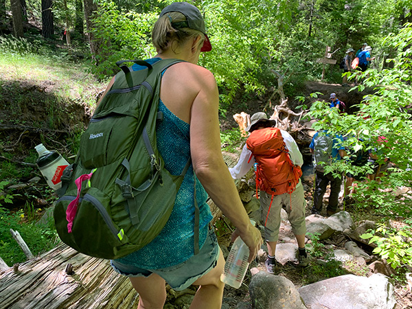
We took our first group photo here and went on descending to the canyon. This part of trail was a little rough with loose rocks and steep declines heading down to the canyon. However, we were rewarded with very scenic views of the mountains ranges. Manzanita bushes blooming with pink flowers beside the pathway provided an interesting point along the trail. I snapped many photos along the trail but felt that the pictures really didn’t do justice to its incredible beauty. As we were heading down the canyon the views got even better. Now we saw lush greens and shaded forest ahead of us. We walked through the tall pine forest while the ground was covered by the healthy dense ferns, and before we knew it we reached the Darling Rock Trail. |
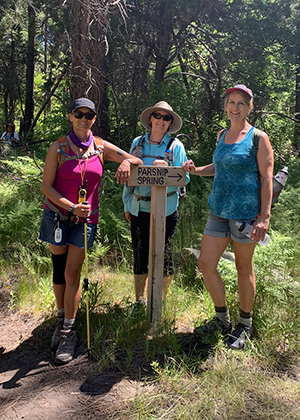 Made it to Parsnip Spring. |
 This seems to be an intersection. |
 Admiring the view. |
 Trailblazers with Milk Ranch Point in the background. |
 Michael tries the stones in the creek to see if they’re loose. |
 Couple sitting on a big rock fishing in the creek. |
|
There was a couple sitting on a big rock fishing in the creek. Michael told us there were rainbow trout in the creek. I did spot a small fish in the water. In order to pass this trail we had a small ascent. Michael helped people get up to the spot. Everyone stopped at the intersection and waited for the people in the back to catch up. |
 Let’s stop and talk this over. |
 Waiting for the others catch up. |
|
We then resumed our journey. After passing a few small intersections I heard a loud noise ahead of us. In the beginning I thought it might be our fast group waiting for us, but then it became obvious there were lots of people. It turned out that a Girl Scott Troop was here for the adventures as well. I took a photo of them and went on to catch up with the first part of our group. Not long after, I saw a few members of the fast group gathered under the shades, talking. There was a neat bridge on the right side, which was a surprise to me. What in the world was a bridge doing here? It turned out this part of the trail connected to the Bear Foot Trail by the bridge which would facilitate people crossing Pine Creek. We took a second group photo here. Everyone looked so happy on the bridge. I was afraid that with so many people, the bridge would collapse, though it held all of us just fine. |
 Li, Carol, and Molly on the bridge. |
 Michael knows the way. After this point we started gradually our ascent. The weather started getting warm and people began shedding layers and trying to find shade, but there was none. When we reached the exposed forest, the scene had changed from a lush green forest to a typical desert forest scene. Alligator junipers greeted us on the path. We did many switchbacks and reached a small hill. This was at about the 5.2 mile mark. I radioed Michael and Terry and confirmed that we needed to have a break, so we found a small shaded area and took our lunch break. |
 Lunch break. |
|
After about 40 minutes of break we continued on. The rest of the trail was typical Arizona forest, with many large and small alligator pines and other species of desert vegetation. There were lots of wildflowers on the hills, which provided a pleasant view for us. On the right side of the trail we could see the town of Strawberry. Many houses could be spotted from the upper hills. We met a few hikers along the way, but overall this is a rarely traveled trail. The end of this trail intersected with the Arizona Trail to the left, the Highline Trail in the middle, and the Pine View Trail on the right. People would have many options of where they would like to go, depending on how many miles they would like to do, which was great for many levels of hikers. |

|

|
| Wildflowers cheer us on the trail. | |
 Strawberry, Arizona. |
|
We never did see the two missing ladies, although they contacted us on their 7 mile mark. Apparently they finished the hike much earlier than we did, so they waited for us at “That Brewery” for lunch. With five drivers sent to the other end to pick up their cars, the group waited patiently at Pine Trailhead. We finally picked up everyone and went to “That Brewery” for our successful hike celebration, but the other two ladies could not wait any longer and headed back to the valley. We had a delicious lunch after a long hike and were all satisfied driving back to the valley. |
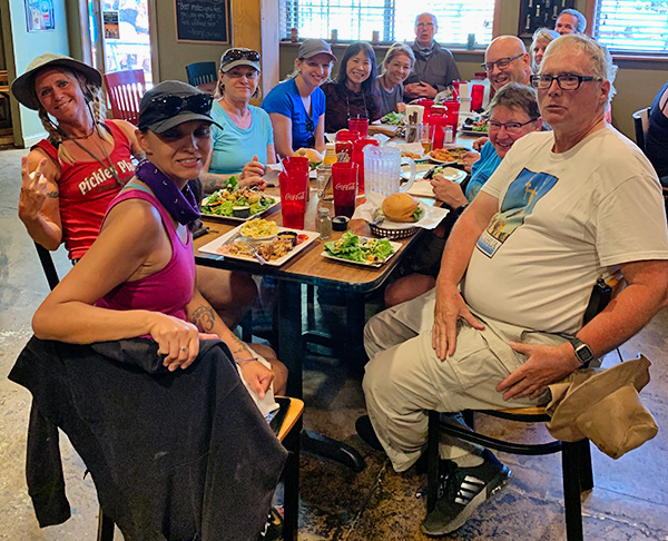 “That Brewery” |
|
This was not a hard hike overall although it covered about 11.75 miles total distance one way. I am planning to reverse the route by heading up to the Cinch Hook side for more a challenging hike next year. → More pictures, by Li.→ More pictures, by Michelle. |
 Top of Page
Arizona Trailblazers Hiking Club, Phoenix, Arizona
Comments? Send them to the AZHC .
updated June 12, 2019