Outdoor Links
Hike Arizona
Trip Planning Guide
Trip Report Index
Calendar of Events
Library
|
See Canyon Day Hike Christopher Creek May 12, 2018 by Chuck Parsons |
|
 Trailblazers start gathering for the group picture. [photo by Quy] |
 14 Arizona Trailblazers gather around the See Canyon Trailhead sign. [photo by Quy] |
|
Front Row (kneeling): Quy, Gary, Cecilia. Second Row: Jim, Chuck, Dave, Tamar, Biljana, Mike, Chris, Heather, Darrell, Bill, Mimi. |
|
On another beautiful Arizona morning in mid-May, 14 eager Arizona Trailblazers set out from the See Canyon Trailhead for a day of hiking adventures (and hopefully no misadventures) in spectacular See Canyon, with the crystal-clear and sparkling waters of Christopher Creek providing a lush riparian habitat along the way. This is going to be quite a treat for us denizens of the desert from our recent desert hikes, where an extremely dry winter and spring have left their mark with abnormally bone-dry conditions and virtually no wildflowers to grace the trails. The time is 8:30 AM, with clear blue skies overhead and a cool and refreshing starting temperature of 60 degrees at the trailhead. Priceless. Today marks only the third time this club has hiked See Canyon, or at least according to the trip reports filed to date on our club’s website. Considering this is such a beautiful hike, although admittedly a bit on the challenging side, it’s hard to believe we’ve only done it three times over the past 22 years since the Motorola Hiking Club started in 1996. Unfortunately, some hike leaders neglect to file a trip report, and that could very likely be the case with this hike as well, thus accounting for the low number. Wendy Rennert first led this hike for the Arizona Trailblazers on July 30, 2011, and oddly enough had the exact same number of hikers (17) that we had on March 23, 2015, when I last led this hike. Apparently (although he may never admit to it) Jim loves this trail so much that he’s the only person in the club to hike it all three times now. Five hikers from the 2011 hike, including Jim, rejoined us for the 2015 hike. And now five more hikers from the 2015 hike (Chuck, Jim, Bill, Dave M., and Biljana) are repeating the hike on this day in 2018. |
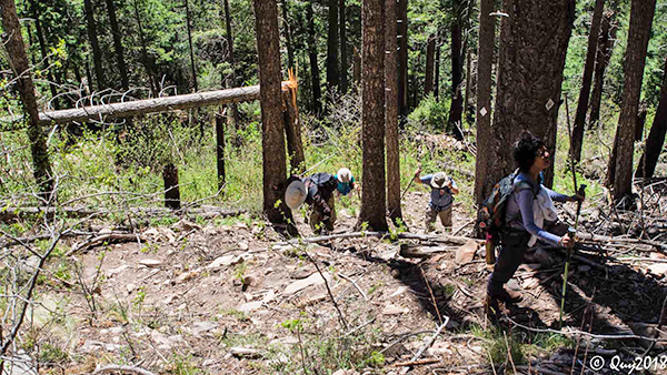
 Trailblazers start moving out on the See Canyon Trail. [photo by Quy] |
 Christopher Creek crossing #1 (of four). [photo by Quy] |
|
With many new hikers in this club who have never hiked See Canyon before and with another three years already passed under the bridge since our last hike, I decided it was time once again to revisit this beautiful slice of Rim Country, Arizona, arguably the most scenic and wild of the few Rim area trails that blaze a challenging path from the base to the very top of the Mogollon Rim. |
 Christopher Creek crossing #2. [photo by Quy] |
 Quy carefully positions her camera for the next photograph. [photo by Dave] |
 A secluded and inviting pool along Christopher Creek. [photo by Bill] |
 Christopher Creek tumbles through, around, and over the numerous boulders in its path. [photo by Quy] |
 Biljana seems to have found the perfect hiking staff. [photo by Dave] About a half mile from the trailhead we come to the trail junction with See Spring and I suggest to the group that we catch that on the way back when we should have more time for exploring. So we continue hiking toward the rim on the main trail. We come to several more creek crossings along the way, all easily negotiated with strategically placed boulders and logs, before the trail begins a gradual incline and starts to move away from the creek altogether. The second mile is a mix of steady, but still relatively gradual, climbing amid easy stretches of fairly level ground. The serious climb still awaits us about two miles in from the trailhead. So this is a good warm-up stretch of trail to help prepare us for the real ordeal that lies ahead, as we begin the steady grind moving upward toward the Mogollon Rim. |
 Christopher Creek keeps rolling merrily along. [photo by Mike] |
 One of many reflecting pools along the creek. [photo by Mike] |
 Small waterfalls are everywhere along the creek. [photo by Dave] |
 This waterfall is surrounded by lush plant growth. [photo by Quy] |
 The fungus among us—shelf fungus. [photo by Dave] |
 More and even bigger fungus among us. [photo by Quy] |
|
Hiking through See Canyon during spring and early summer, especially along picturesque Christopher Creek, is about as close as you can come to experiencing a rainforest environment on an Arizona hike. The trail meanders through a lush green riparian corridor, courtesy of the perennially flowing creek, for roughly a mile or more, surrounded by tall grasses, knee-high bracken ferns, moss-covered logs and rocks, small grass-filled meadows, and abundant wildflowers in a good year—all under a dense forest cover of giant ponderosa pines, junipers, colorful bigtooth maples, box elders, mountain ash, Manzanitas, and several different species of oaks. This is literally a botanists paradise, with few counterparts anywhere in Arizona. We also come across some of the largest alligator juniper we’ve ever encountered while hiking in Arizona. These hardy trees can live up to 500 years. And judging from the size of some of these massive trees, they must be approaching that point already. Higher up on the trail, approaching the rim, we’ll start to see increasing numbers of quaking aspen and towering Douglas fir. Even if you want to hike to the top of the Mogollon Rim in the middle of summer, this is your trail. |
 See Canyon Trail meanders through the tall pines. [photo by Mike] |
 White diamond markers on the trees help keep us on the correct path. [photo by Mike] |
 Chris and Heather stop for a quick break on the trail. [photo by Darrell] |
 Interesting rock pillar along the trail. [photo by Darrell] |
|
Just be aware of the very real dangers of flash flooding along Christopher Creek during peak monsoon season and start hiking as early as possible. And above all, don’t even think about tempting fate by trying to cross high, rushing waters because you definitely won’t make it. On almost all of our hikes so far this year, including all of our desert hikes and hikes in both the Prescott and Sedona areas, we’ve seen very few, if any, wildflowers. Due to an extremely dry winter and spring, this has been the leanest wildflower season in recent memory. However, as seen in this collection of colorful wildflower pictures from Quy and Dave, that is certainly not the case around See Canyon and Christopher Creek. Where there’s water, there’s life. And where there’s life, there’s wildflowers. |
 New Mexican Raspberry with visitor. [photo by Quy] |
 Moth or butterfly? [photo by Quy] |
 The pollinators are hard at work. [photo by Quy] |
 Collage of See Canyon wildflowers. [photo by Quy] |
 Dandelion. [photo by Dave] |
 Low Larkspur. [photo by Dave] |
 New Mexican Raspberry. [photo by Dave] |
 Golden Pea. [photo by Dave] |
 Another pollinator hard at work. [photo by Dave] |
 Emerging from the ground. [photo by Dave] |
|
This collection of beautiful wildflower pictures is proof positive. Meanwhile, throughout most of the rest of Arizona, billions of wildflower seeds will continue to lay dormant in the ground, awaiting just the right moisture and temperature conditions to germinate and burst from the ground in a riot of color that we’ve become so accustomed to seeing on our spring hikes in the desert and summer hikes in Arizona’s high country. |
 Green False Hellebore. It may look tasty, but steer clear of this one. [photo by Mike] |
 As Ted is fond of saying: “Alice Algae and Fred Fungus have married and taken up residence here.” [photo by Quy] |
 Lichen have taken a likin’ to this boulder. [photo by Quy] |
 Let’s hope the long proboscis on this guy doesn’t also serve as a stinger. [photo by Quy] |
|
Curious minds may wonder about the origin of the name for this canyon. See Canyon and its namesake trail are named after the pioneering See family (John See, along with his wife Annie and their infant son Charlie), who settled in this area in the late 1880s and built a small working ranch on Christopher Creek. Unfortunately, the story doesn’t end there, and the family did not live an idyllic happily-ever-after existence along beautiful Christopher Creek. In what may well be Arizona’s oldest open-murder case in history, John See allegedly shot and killed his young bride, Annie, in May of 1892 as she was milking the family cow, of all things. One has to ask the question, why? Unfortunately, his motive for doing so is forever lost to history. |
 Parting shot of Christopher Creek. [photo by Mike] |
 Aspens mean we’re climbing even higher. [Dave] |
|
Their son, Charlie, was apparently the sole witness to the crime and obviously far too young to remember anything. John See shortly afterward went to his parents’ nearby home and supposedly confessed to the crime before fleeing to Mexico, along with his younger brother Bob, whom their mother insisted go along for safety reasons. Bob eventually returned to Arizona some years later. But John, by now comfortably settled into his new double-life in Mexico with a Mexican wife and children, never returned to America. As the story continues to unfold, many years later a much older John See wanted to see his first son, Charlie, once more before he died. Upon hearing this request, Charlie and a close cousin traveled to Mexico and met with his father and stepmother, before eventually returning to Payson. Did Charlie ever forgive his father for killing his mother? That too is apparently lost to history. |
 What happened to the trail, Biljana? The going really starts getting tough now. [photo by Dave] |
 Jim, Chuck, and Cecilia scramble up the “trail”. [photo by Quy] |
 Rebuilding cairns to help mark the way. [photo by Quy] |
 This is Chuck, Mimi? Where are you? Do you copy? [photo by Quy] |
 Trailblazers continue to struggle up the trail. And the operative word here is “UP”. [photo by Quy] |
 Yet another fallen log to get across. [photo by Quy] |
|
The original See family ranch on Christopher Creek was purchased by another couple in the late 1920s and demolished, but the original logs were reused to build another cabin nearby. Sound like an interesting plot for a movie? Who knows just how many such stories, both told and untold, exist across this state? Many may never reveal themselves, remaining untold for eternity. The weather forecast for today calls for winds increasing to 20-25 mph in the afternoon, with possible gusts to 35 mph. We start getting some winds early in the hike, but as we start climbing higher and higher on the trail those 20-25 mph winds are fast catching up with us. I’m just hoping some of these tall dead trees all around us don’t start crashing down from a big wind gust. Although much of it has gradually become overgrown over the years, we can still see occasional evidence of the Promontory Fire, started by a careless camper in May, 2007, in the form of charred trees (some still standing and some long-fallen) and burned-out tree stumps. The fire eventually burned through over 4,000 acres before finally being extinguished several weeks later. At about the two-mile point, the trail dips down into one last rocky ravine before scrambling back out and beginning the primary ascent to the top of the Mogollon Rim. From this point on it’s going to be a steady grind all the way to the top, with only occasional short descents and level stretches that will be few and far between. So it’s onward and upward from here on, with the key emphasis on upward. We traverse through one long series of switchbacks after another, as we continue to claw our way to the top of the Rim. You think you’re getting closer when you start to see open sky ahead through the trees, only to find out later you still have several hundred feet of additional elevation to conquer. Legs, lungs, and feet—please don’t fail us now! With occasional rest breaks, we continue to push our way through one set of switchbacks after another. With each set of switchbacks behind us, we have to remind ourselves that we’re that much closer to the top. At one point Jim tells me that we are at the 7,500-foot level according to his GPS, and I realize we now have only a few hundred feet of additional elevation gain to go. As the winds increase in speed, the temperature is getting noticeably cooler as we approach the top of the Rim. We struggle through a really steep section of trail full of loose dirt and rock rubble, and I remark to anyone listening that this is going to be especially treacherous on the way back down. Those of us with hiking poles are thankful that we have them on this hike. Jim, Mike, Mimi, Cecilia, and yours truly are bringing up the rear of this increasingly stretched out group of hikers. By the time we’re within about a quarter-mile from the top, we start seeing others in our group already heading back down. When the five of us finally reach the Rim, almost everyone else except for Quy has already left. So we settle down on a long ponderosa log for a well-deserved lunch and rest break. Although not quite as windy on the Rim, it’s still cool on the verge of being chilly. But let’s enjoy these cooler temperatures for as long as we can. We all know that triple digits will soon be the norm once again for the Phoenix area, and we’ll all be looking back on this cool day in Rim Country and wishing we could do it all over again. |
 The first wave of Trailblazers gathers for lunch on the Rim. [photo by Bill] |
 A while later it’s the second wave of Trailblazers on the Rim. [photo by Quy] |
|
Lunch over all too quickly, we start the long and thankfully uneventful trek back down the trail. As far as I know, no one took a dive or unintentionally summersaulted down the trail. |
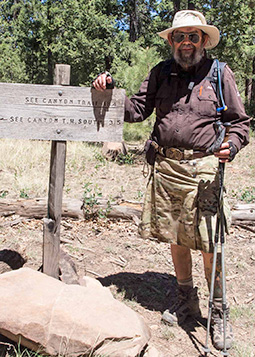
 Mike next to FR300 and the See Canyon Trail sign. [photo by Mike] |
 Chuck & Mike standing in the middle of FR 300. [photo by Quy] |
 Tamar, Darrell, Bill, Gary, and Biljana on the Rim Road, FR 300. [photo by Dave] |
 Quy gets in one last shot of the trail, as we head back down. [photo by Quy] |
 Bill sneaks in one parting shot of Christopher Creek on the way out. [photo by Bill] |
 And Quy simply can’t resist one more waterfall picture. [photo by Quy] |
|
At the end of most of our hikes, especially those in the Prescott, Sedona, Flagstaff, or Payson areas, the last major decision of the day typically centers around where to stop for dinner. It’s a long drive back to the valley, and few of us care to deal with dinner preparations after a long day of driving and hiking. We typically stop at one of several different locations in the Payson area for dinner, but this time both Gary and Bill highly recommend Macky’s Grill on Main Street as an alternative. So that’s where we find ourselves after finally arriving back in Payson. Several hikers in the group decide to head back to Phoenix, while the rest of us hungry hikers gather on the spacious and shaded outside patio of Macky’ Grill for a late lunch. And we’re certainly not disappointed. This will now be one of our post-hike go-to restaurants in Payson. Thanks for the suggestion Gary and Bill. And now for that long drive back to Phoenix. |
|
Supplemental Report by Jim Buyens |
|||||||||||||||||||||||||||||||||||||||||||||||||
|
It was great seeing everyone again on Chuck’s See Canyon Trail hike. As always, the company was the best part. At times during this hike I felt I was struggling. I’m not really into steep slippery or steep rocky footing. I made it to the top, though, and now that I’ve checked, I see I matched the same average speed as three years ago. So maybe I did better than I thought. Here are the statistics I recorded. These don’t include the side trip to See Spring, which I skipped. The distance jibes with what I measured three years ago, and I didn’t see any errors from GPS waves echoing against canyon walls, so I think this is accurate. Jim |
|||||||||||||||||||||||||||||||||||||||||||||||||
|
|
||||||||||||||||||||||||||||||||||||||||||||||||
 Top of Page
Arizona Trailblazers Hiking Club, Phoenix, Arizona
Comments? Send them to the AZHC .
updated May 18, 2018