Outdoor Links
Hike Arizona
Trip Planning Guide
Trip Report Index
Calendar of Events
Library
|
Arizona Trail 50th Celebration South of Grand Canyon October 6, 2018 by David French |
|
 All together now. [photo by Quy] |
| Barry, Doug, Ralph, Dave, Diva, Michael, Sandy, Dwight, Billie, Yanis, Vicky, Terry, Michelle, Mimi, Mark J, Zulma, Mark P, Benita, Quy |
|
This hike was part of a statewide event by the Arizona Trail Association to celebrate the 50th Anniversary of the National Trails System Act. The Arizona Trail is part of the National System of Scenic Trails. The AZT Association divided the 43 passages of the AZT into 97 sections and wanted to have someone or group on each section on October 6. I initially signed up for section 75 of Passage 37, Grand Canyon South. The AZT requested a maximum of 10 people per group. I got lots of interest and noticed that the next sections to the north had no one signed up, so I signed up for sections 76 and 77 of Passage 37 as well. Section 75 is 10 miles and sections 76 and 77 combined are 12.5 miles long. Passage 37 extends from the Grandview Lookout Tower and trailhead to the South Kaibab Trailhead at the edge of the Grand Canyon. I got 20 people to sign up but one dropped out a couple of days before the hike. So we had 9 hikers on section 75 and 10 hikers on sections 76 and 77. Michael and I each reserved a house in Williams for the nights of Oct 5 and 6 through Airbnb. Two hikers stayed in Flagstaff, two in a motel in Williams, and one in Sedona. There were 8 hikers in Michael’s house and 6 in mine. On Friday October 5, a total of 18 hikers arrived in Williams, checked into the houses or motel and met at Historic Brewery for dinner and drinks. |
 We met and stayed in Williams. [photo by Quy] |
 Eating at Historic Brewery. [photo by Quy] |
|
I used this time to consult with those that drove to arrange for shuttling people to the trailheads the next day. That proved to be very helpful so that we were pretty well organized on Saturday morning. |
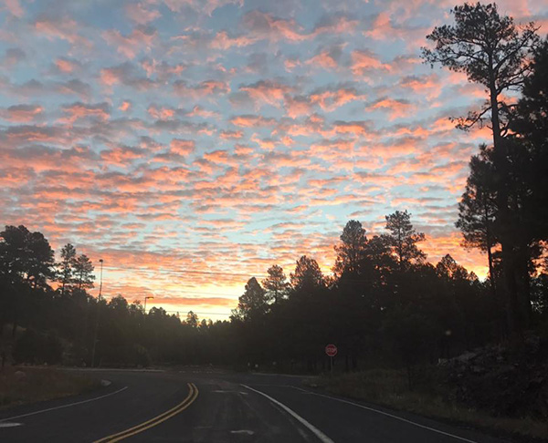 Early morning drive to Tusayan. [photo by Ralph] |
 Let’s get organized. [photo by Quy] |
|
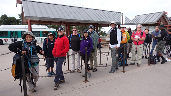
We met just off SR 64 on FR 302 in Tusayan at 8 AM. After a group photo, we put our end of hike stuff into 2 cars for each of the two hiking groups and our hiking gear into 2 cars for each group. We drove four cars plus one to the common ending point on FR 2709 and came back in the 5th car. We then loaded into 2 cars for each group and headed for the beginning trailheads. |
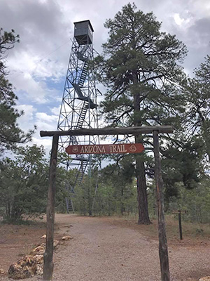 Grandview Tower. [photo by Diva] |
I led the group from the Grandview Trailhead to FR 2709 and Michael led the group from the South Kaibab trailhead to FR 2709. Both groups had to enter Grand Canyon National Park to reach the beginning trailheads. I will describe the Grandview (westbound) hike first. The Grandview Trailhead is located about 11 miles east of the Visitor Center on SR 64. There is a Grandview overlook of the Canyon at about 9 miles, so I was a little confused as to why our trailhead was called Grandview. It is located further east and south of SR 64 about 1.3 miles. When we got there we realized why: there is a large observation tower. None of us climbed the tower, because we knew we had a 10-mile hike ahead of us. When we returned to get the cars at the end of the hike we did not climb it then either, because we had just done a 10-mile hike. |
 NB group: Doug, Ralph, Barry, Billie, Mark, Sandy, Diva, Mimi. [photo by Dave] |
 Les’s go. [photo by Diva] |
 Trailblazers take a brief pause. |
|
After taking a group photo of our 9 hikers, we headed west on the Arizona Trail through a nice forest at an elevation of over 7500 feet. The trail is flat with a gentle downslope most of the way, easy hiking. It was cloudy and cool the whole day with some light rain towards the end. We found some nice boulders to sit on about half way and took a lunch break. At one point we were hiking on an old road and came to a new wooden sign for the Arizona Trail that gave mileages in both directions; however, there was also a road junction at that point and no indication of which road we should take to continue west. The minimal forest road signs did not match the information in the data book info I had downloaded from the AZT website. A couple on an ATV approached, and we asked if they had seen AZT signs on the road they had driven on. They had not, but got out a more detailed map. He advised us to turn right at this point. |
 Dry Watson Tank. |
|
We started in that direction, but I did not feel comfortable at all. We looked back at the junction and spotted a through-hiker going southbound on the trail on the other road. We turned around and took that road and soon found an AZT marker where the trail departed from the road. I felt much better. We continued on the hike without incident and reached our two cars parked at the ending point on FR 2709. |
 Lunch time. |
 Trail junction. |
|
About half of the trail was single track and most of the rest was on old forest roads currently closed to vehicle traffic. We loaded up and drove back to SR 64, and I took the drivers back to the two cars we left at Grandview. On the way we spotted a beautiful rainbow in the Grand Canyon. |
 Rainbow over the Grand Canyon. [photo by Ralph] |
|
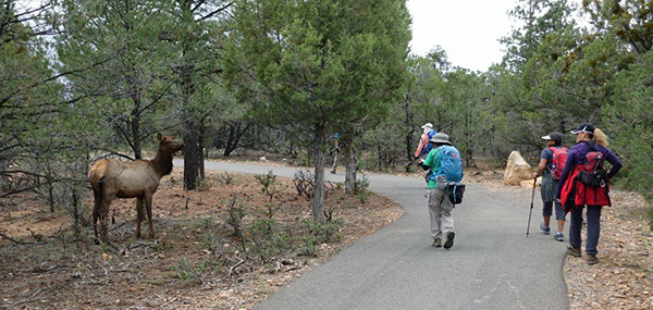
Michael’s group of 10 hikers drove to the main visitor center in Grand Canyon National Park and got onto the bus for the South Kaibab Trailhead. They headed southbound on the Arizona Trail, which is initially a westbound paved walkway right along the rim of the canyon. They had spectacular views of the canyon and many photo ops. They were enjoying the views, so they continued about a half mile beyond where the AZT departs from the Rim Trail to head south toward Tusayan. So they returned to the AZT and found that it is paved all the way to Tusayan. Easy walking, but not what any of us expected. Along the way they saw many elk just lying or grazing near the trail and completely unconcerned about the passing humans. |
 SB Group waiting for the bus to South Kaibab Trailhead. [photo by Yanis] |
 Mark, Michelle, Terry, Vicky, Yanis, Quy, Zulma, Michael, Benita, Dwight. [photo by Quy] |
 Grand Overview. [photo by Quy] |
 Grand Overview. [photo by Yanis] |
 Zulma takes in the view. [photo by Dwight] |
 What a view! [photo by Quy] |
 It gets mighty steep. [photo by Yanis] |
 South Kaibab Trail. [photo by Dwight] |
 I am watching you. [photo by Yanis] |
 ... and we are watching you. [photo by Dwight] |
 Friendly tarantula joins us on the trail. [photo by Dwight] |
 A paved trail isn’t quite what we expected. [photo by Quy] |
 Leaving Grand Canyon National Park. [photo by Dwight] |
|
Just as the group reached the point near Tusayan where the trail makes a turn to the east to pass through a tunnel/culvert under SR 64, it started to rain. They were able to take refuge in the tunnel until the rain let up and then continue eastward on a welcomed unpaved single track for the last 4 miles. They loaded into the two cars and returned to the meetup place at SR 64 and FR 302. |
 Emerging from the tunnel. [photo by Quy] |
 Nice to be on a real trail. [photo by Quy] |
 End of trail. [photo by Yanis] |
|
The combined group decided to return to Williams for supper and chose to eat at the Pizza Factory in downtown Williams. All but two of the hikers chose to eat here. After eating we returned to the rented houses in Williams, or to homes in Flagstaff and Sedona for a nice restful evening. Those of us in Williams were awakened after midnight to thunder and lighting. The next morning, we were very surprised to see that it had snowed about two inches. After taking some photos we loaded up and headed for home. The drive back to Flagstaff was quite foggy with very low clouds. Once we got to Flagstaff we were greeted with beautiful views of the San Francisco Peaks covered with fresh snow. The drive back to Phoenix was uneventful. |
 Surprise snowfall in Williams. [photo by Quy] |
 Quy, Benita, Billie, Zulma, and Vicky enjoy the snow. [photo by Quy] |
 Foggy drive to Flagstaff. [photo by Dwight] |
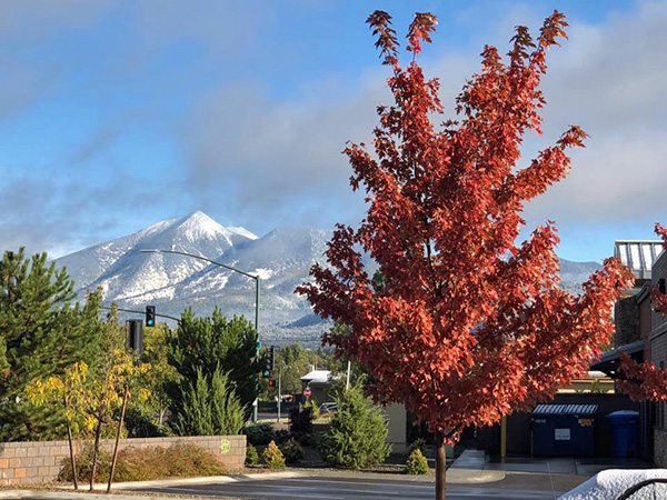 Fall and winter in Flagstaff. [photo by Ralph] |
|
All in all, I believe everyone had a great time on this venture. The accommodations were good, the food was good, the hike was good, and the companionship was great. My group hiked 10.5 miles in 4:55 hours, climbed 440 feet and descended 1145 feet. The elevation ranged from 6867 to 7578. Michael’s group hiked 13.7 miles in 6:15 hours, climbed 1385 feet and descended 1737 feet. The elevation ranged from 6609 to 7206. |
 Top of Page
Arizona Trailblazers Hiking Club, Phoenix, Arizona
Comments? Send them to the AZHC .
updated October 10, 2018