Outdoor Links
Hike Arizona
Trip Planning Guide
Trip Report Index
Calendar of Events
Library
|
Walkin’ Jim Trail Day Hike Cottonwood Creek west of Lake Pleasant April 22, 2017 by Mark Jelsma |
|
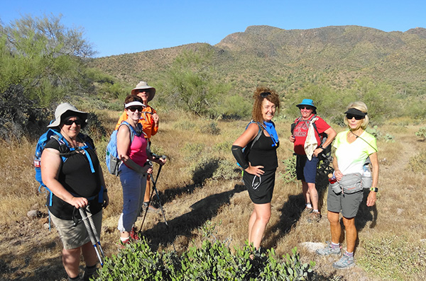
 Group of 16 hikers. [photo by Dave F.] |
|
Kneeling: Yanis, Monica. Standing left to right: Tom, Lance, Tamar, Michelle, Mark, Billie, Kari (trying to hide in the shadow of the saguaro), Zelijka, Dave F., Dubravka, Bilijana, Ed, Dave M., Jim. |
|
A group of 16 hikers hit the trail at 6:40 to get an early start on the day, knowing the temps are forecast to be in the high 80s by noon. |
 Crossing Cottonwood Creek. [photo by Lance] |
|
The trail takes us across the Cottonwood Creek, where many puddles of water still exist from the spring rains. |
 Off we go. [photo by Dave M.] |
|
We welcome the nice covering of shade at the start of the hike, although the temperature to start the hike was a comfortable 63 degrees. |
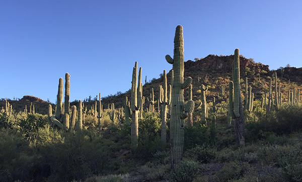 A Sea of Saguaros. [photo by Lance] |
|
As we make our way on the trail we pass through what seems like a sea of saguaros. They stand above us in all shapes and sizes. |
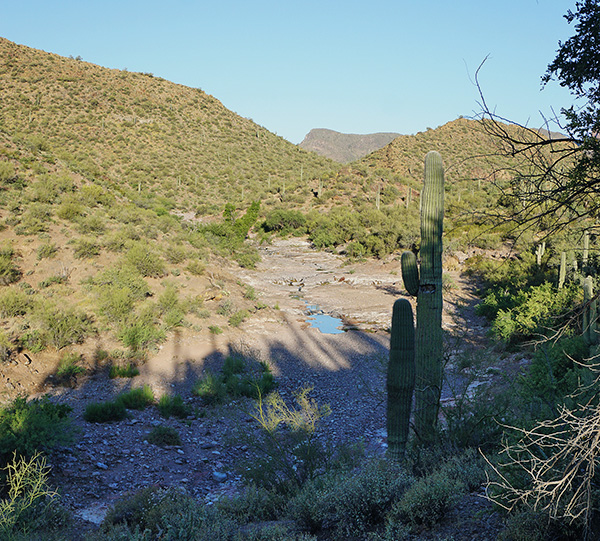 Cottonwood Creek. [photo by Dave M.] |
|
We cross many small tributaries that flow into the cottonwood creek. Along the way we get many glimpses of the creek and the puddles below. |
 A group of free range cattle. [photo by Dave M.] |
|
We come upon a group of cattle that appear to be looking for some grass to graze. Most of the grass has died by now. The cattle stand by and watch as we hike on by, keeping an eye on our every move as we keep our eyes on them. There were a couple with some pretty big horns. We wanted none of that. We moved past them with no conflicts. |
 Rock Formation. [photo by Lance] |
|
As we traversed along the trail we passed some red rock formations. |
 A quick break to catch our breath and let the others catch up. [photo by Dave F.] |
|
The trail takes us over some of those red rocks and up the hill and over into Hells Canyon Wilderness. A quick break was needed to catch our breath before we continue our adventure. |
 One of many open meadows. [photo by Dave M.] |
|
We pass by and through many meadows that were lush green just a month before. Now the grass has all died and we walked through brown fields of foxtails that stuck to our socks and shoes. |
 Getting closer to Big Jim. [photo by Lance] |
 We are taking the Walkin’ Jim today. [photo by Tom] |
 The trail is this way. [photo by Tom] |
 Snack break. [photo by Tom] |
|
About 4 miles in we hit an intersection in the trail. This is the point where you have an option to climb the Big Jim. Today, we are staying on the Walkin’ Jim and completing the loop back to the trailhead. After passing by the Big Jim we continue on for a while until we find a wash that has some rocks to sit on and some shade to cover us from the late morning sun. We stop to take a snack break and try and pull some of the foxtails out of our ankles. |
 The trailhead is out there somewhere. [photo by Tom] |
|
After our snack break we head out with Lake Pleasant in front of us. The trailhead is about 4 miles away. |
 A King snake lurking on the trail. [photo by Tom] |
|
As we continued on our way, enjoying the remote wilderness, the peace and quiet, we spotted a snake peeking out of the dead foxtails right in front of us on the trail. This heightened the excitement of all the hikers. Some wanted nothing to do with it and others wanted to get their photo ops in. The friendly King snake waited patiently for us to move on and leave him alone. We continued on our way and it wasn’t too much further down the trail when the distinct rattle of a rattlesnake stopped the group in their tracks. We quickly spotted the rattler, blended in with the dry desert rocks and foliage. Once the snake knew we were stopped, he slithered his way across the trail and curled up under a bush right next to the trail. We checked the desert to the right of the trail to make sure there were no more and we made our way up and around the bush so as not to invoke the rattler. Phew ... that got the heart pumping. |
 The wash leads us to our trailhead. [photo by Lance] |
|
With about 2 miles to go, unfortunately, a hiker took a fall. He sustained some cuts and abrasions but we got him cleaned up and bandaged and, after a short delay, we were on the move again. The trail takes us across a wash that leads into Cottonwood Creek. After the wash crossing there is quite a hill to climb to get over the mountain back to the trailhead. Due to the injured hiker, when we reached the wash we decided to take the wash back to the trailhead. |
 We finally have a burro sighting. [photo by Dave F.] |
|
Although the wash did have its own challenges, such as slick rocks, more water than anticipated, and lots of rocks to walk over, we were treated to some wildlife and nature. We finally came across a wild burro. We heard them before we saw them and we are sure, based on the noises, there were more than one; however, only one stood there, curious about us as we were about him. |
 Puddle of tadpoles. [photo by Dave M.] |
|
As we did the last stretch down the wash we came across many puddles that were full of tadpoles. |
 Eastern Mojave Buckwheat. [photo by Dave M.] |
 Desert Mariposa Lily. [photo by Dave M.] |
 California Poppy. [photo by Dave M.] |
 Strawberry Hedgehog Cactus. [photo by Lance] |
|
Even though the trail was quite dry we still were able to enjoy some wildflowers throughout the hike. We will definitely have to get this one on the calendar earlier in the spring next year. We made it back to the trailhead by 11:15 with the temperature already hitting 88 degrees. We were happy for the early start. A group of 10 hikers made their way back to the meeting point and went to Azool’s Grill for some much deserved lunch, as well as, great conversation and camaraderie. |
|
Supplemental Report by Jim Buyens |
|||||||||||||||||||||||||||||||||||||||||||||||||
|
It was great seeing you all on today’s hike, and great being with the club again. I had a great time and I hope you did too. I think we just beat the higher temperatures later in the day. I picked up a few stickers but you have to expect that hiking on narrow trails through dry grass. Mark and Michelle, thanks for leading a wonderful hike. I hope you found the task rewarding and there are many more to come. Jim |
|||||||||||||||||||||||||||||||||||||||||||||||||
|

|
||||||||||||||||||||||||||||||||||||||||||||||||
 Top of Page
Arizona Trailblazers Hiking Club, Phoenix, Arizona
Comments? Send them to the AZHC .
updated April 30, 2017