Outdoor Links
Hike Arizona
Trip Planning Guide
Trip Report Index
Calendar of Events
Library
|
Gooseberry Springs Day Hike Mormon Lake Village June 18, 2016 by Dave French |
|
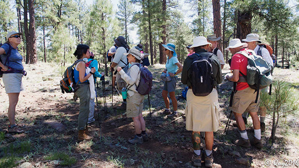
 Group [photo by Quy] |
||||
|
|
On a day when the temperatures in the Valley were forecast to be over 110 degrees, 21 hikers met at a cool 7300 foot elevation in the pine trees to do a 9.2 mile hike. Eighteen hikers drove up from Fountain Hills in four cars and three hikers met them at the trailhead. The hike leader had expected the Phoenix folks to take about 2 hours to make the drive, but it was more like 2.5 hours and almost 3 hours for one car. After shuttling 4 cars to Mormon Lake Village and returning in one, we took the group picture and got underway about 9:45. |
 In the beginning there was grass. [photo by Quy] |
 Then there were trees and it was good. [photo by Quy] |
 Forest thinning near the highway. [photo by Quy] |
|
The trail starts out with some open grassy areas, and we cross FR 3 where forest thinning along the roadway was well underway. After passing through three gates we traversed along an old road bed. The group had already gotten somewhat spread out and the hike leader was toward the back to make sure the gates got closed. I got a radio call from Michael who was a few hundred feet behind me saying there is a sign saying we should turn right to stay on the Arizona Trail. |
 Oops, we were not suppose to cross a cattle guard. [photo by Quy] |
 Pause to let everyone catch up. [photo by Quy] |
|
About that time I reached a cattle guard crossing and realized I had not crossed that when I pre-hiked this trail a few weeks ago. Most of the hikers had already crossed the cattle guard. At that point I called them back and we bushwhacked back to Michael and a couple of other hikers that were alert enough to spot the AZT turn off. Thanks to Michael for catching this mistake as quickly as he did. |
 We live by the lake. Drop in. |
 Yes, this is our trail. We stopped for snacks or light lunch about 11:30 and then continued on. For the most part the trail is very flat. There was a stretch at about 5 miles that had a long gentle up grade. Near the junction with the Navajo Springs trail there was a down grade. |
 Snack break. [photo by Quy] |
 Dave M., Biliana and Emma find a comfortable log. [photo by Quy] |
 Glad to be on the down grade as we pass Navajo Springs. |
 Woodsy section of the trail. |
|
We gathered at the trail junction to make sure everyone made the right turn. We passed by Navajo Springs where there were several concrete troughs that I assume were used to water horses and cattle at some time in the past. We also passed by an area where the Forest Service had fenced off a grove of young aspen trees to protect them from the wildlife. After a 1.3 mile descent on the Navajo Springs trail, we reached the Mormon Lake Village where our cars were parked. |
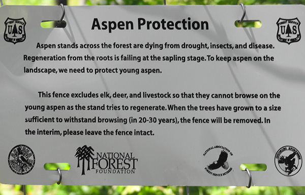 No munching on the aspens. |
 Tall Mountain Larkspur [photo by Quy] |
 Lindley’s Silverpuffs [photo by Quy] |
 Indian Anoda [photo by Quy] |
 Woods’ Rose [photo by Quy] |
 Field Bindweed [photo by Quy] |
|
Several of the hikers immediately went into the pizza restaurant an enjoyed the cool and some food and drink. One carload decided to start the drive back to the Valley immediately. The hike leader scrambled around to make sure we had enough cars to get everyone back to the trailhead where two cars remained. Some of the group decided to go to Mormon Lake Lodge to eat. Fortunately that turned out to be the group that came up in one car. The rest of us ate quickly at the pizza place and then loaded five people in one car and 6 in another and drove back to the Gooseberry Springs Trailhead. Everyone made it back home safely. The 9.2 miles took 4.5 hours for everyone to get out. Elevation ranged from 7100 at Mormon Lake Village to about 7500 at the highest point. For those interested in hiking the Arizona Trail, this makes a good day trip. Much of the Arizona Trail has limited vehicle access so that one either has to backpack, hike in and back out, or form a loop with another trail. A special thanks to Bill for taking charge of forming carpools in Fountain Hills since the trip leader was in Munds Park, where it was 45 degrees at 6:30 AM. |
 Top of Page
Arizona Trailblazers Hiking Club, Phoenix, Arizona
Comments? Send them to the AZHC .
updated July 13, 2018