Outdoor Links
Hike Arizona
Trip Planning Guide
Trip Report Index
Calendar of Events
Library
|
Ballantine Trail Day Hike Mazatzal Mountains February 25, 2006 by Beth Baumert |
|
|
Hike leader: Beth Baumert Hikers: Michael Humphrey, Chuck Parsons, Emie Sorongon, Lyndon Tiu, Dan Varner |
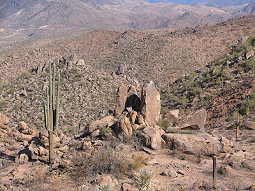
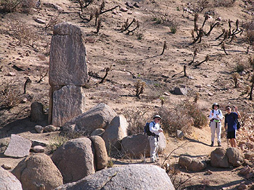
It was a bright, sunny day, with just a few high cirrus clouds in the blue sky, and just a little air pollution to the west, wafting up from the valley. It was around 70° by noon and was headed up to 80° by 4:00 PM. We took the right fork of the Pine Creek Loop from the parking lot and ascended the hill, with views of the highway and surrounding valley to the left and nearby peaks to the right. We climbed up through the desert and chatted about the winter Olympics. There was no sight or sound of any water in the creeks to the left and right of the ridge we were descending down to the Ballantine Trailhead, which is 1.5 miles in. Suddenly, to the left, everything was scorched and blackened, and far below near the creek bed we could see a line of chili-pepper red fire retardant sprayed onto the ground. Unfortunately, the whole area around the Ballantine Trailhead was blackened, and it continued as we ascended the hill past red rocks and eroded granite boulders and hoodoos. We could see the devastation from the fire all around as we reached the plateau lookout point, from which one can see a huge balanced rock monolith as well as a bridge on the beeline which is an impressive engineering feat (it was written about in the Dec. 15, 1997 issue of Engineering News Record). The barrel cactuses were singed to the point where their needles were burned off, many saguaros were yellow or black, and the yucca plants had burned to charcoal, leaving only some yellowed leaves and a short stem which made them look like a black pineapple. The rock formations were still magnificent and the surrounding scenery was still quite beautiful, but it was depressing to see the eroded jumble of dirt and rocks with blackened cholla and other cacti interspersed. There were a few jojoba bushes and some other green plants poking their heads up, but most of the area was badly burned and had not recovered. |
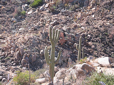
We were very relieved to see that the hand-shaped saguaro was still standing and was only burned slightly at the bottom. We had our lunch break in the rocks nearby in the warm sunshine there, with a slight breeze blowing but unfortunately without the sounds of the creek running. We then proceeded up to Boulder Flats before returning, for a total of nine miles. It was an enjoyable hike but was very depressing for me to see yet another of my favorite hiking areas charbroiled. All photos courtesy of Michael Humphrey. |
 Top of Page
Arizona Trailblazers Hiking Club, Phoenix, Arizona
Comments? Send them to the AZHC .
updated March 11, 2018