Outdoor Links
Hike Arizona
Trip Planning Guide
Trip Report Index
Calendar of Events
Library
|
Coffee Flat Mountain Day Hike Superstition Wilderness November 12, 2011 by Ted Tenny |
|
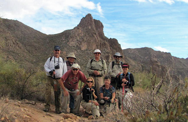 Don, Ted, Bill, Wendy, Dick, Eileen, Jim, Monika [Bill Zimmermann photo] |
 Picnic on the top of the world. [Bill Zimmermann photo] |
Weather forecasts were iffy, but when we got to Peralta Trailhead we had a cool, mostly cloudy day with mild breezes and occasional patches of blue sky. We walked up to Miner’s Summit on the Dutchman’s Trail, then took the Whiskey Spring Trail east to the pass before it dips down into Whiskey Spring Canyon. Then we bushwhacked. |
|
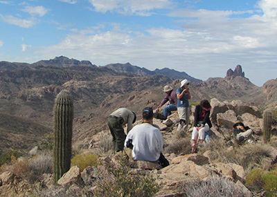
The west bend of Coffee Flat Mountain tops out at a place called Circle, named on the USGS topographic map and identified by two markers of the US Coast & Geodetic Survey. After leaving the Whiskey Spring Trail our climb up to Circle is an easy off-trail route with increasingly dramatic views of the surrounding mountains. From the top we enjoy a gorgeous panorama in all directions, with boulders to serve as picnic benches. Clouds blow over as we enjoy our lunch, highlighting one feature then another with filtered sunlight with the surrounding scenery in shadow. |

|

|
| “Circle” is identified by dual US Coast & Geodetic Survey markers dated 1946. | |
|
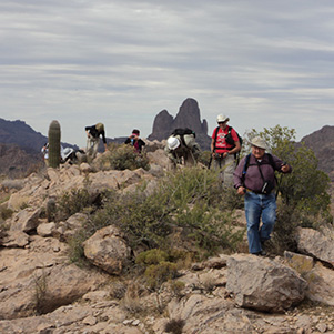
Ted gathers all the hikers together to decide what to do next: return on the trail or continue east along ridgeline and eventually bushwhack down into Coffee Flat. Everyone chooses the ridgeline. So our plan is to start down at a saddle where we get a good view of Cathedral Rocks from above. |
|

|
| OK, Ted, are you sure this is the best way down? [Eileen Root photos] | |
|
East of Circle the ridge gets rough, with a series of buttes that have to be contoured around, either on the left or on the right. We contour around the first one on the left, then up to one of the saddles above Cathedral Rocks. Here we are looking at a steep slope interrupted by an outcropping with canyons on either side. Bill and Ted look at the possibilities for climbing down. |
 Miner’s Needle from above, at Circle. |
 Miner’s Needle from below. |
 Miner’s Needle, sideways. |
 It’s a challenging climb down the mountain ...  ... but Trailblazers emerge victorious on the Coffee Flat Trail. We cross the first canyon and make our way past the outcropping, arriving at the top of the second canyon. Here Bill sees a route down and begins his descent. Eileen goes with him. Ted finds a way across the canyon to get to the slope on the other side. Jim goes with him. What are Don, Wendy, Dick, and Monika going to do? “Whether you take the White Pass Trail or the Chilkoot Trail, you’re going to wish you had taken the other one,” a wise man told Alaska miners bound for Dawson in 1898 as they lugged their supplies up to the Canadian border. So it was with our steep, rocky descent from Coffee Flat Mountain — minus the gold. |
 Cathedral Rocks from Coffee Flat Mountain.  Mama bear and baby bear on Cathedral Rocks. |
Our party of 8 has split into 2 plus 4 plus 2. After some discussion back and forth, Don, Wendy, Dick, and Monika follow Bill and Eileen down the canyon. They quickly lose sight of Jim and Ted. Well, it turns out the slope on the east side of the canyon isn’t as moderate as it looked from the other side. It’s rocky and very steep, with an outcropping that we have to go up and over or down and under. Ted and Jim find a perilous route over the outcropping and then have to make several butt slides before the slope moderates as we approach Cathedral Rocks. But here the route is choked with dense vegetation composed of friendly jojoba interspersed with vicious catclaw. “I wish we could see our hiking companions,” Ted remarks as we cross a streambed to escape the catclaw. Eventually we do see them, far behind us, then lose them again. |
|
The going gets easier as we lose elevation. We spot a can and a lid, indicating that somebody has been here before, then a cairn. The Dutchman’s Trail comes into view on the right, then, finally, the long-awaited Coffee Flat Connector Trail. From here Jim and Ted have an easy walk to the trail junction, where they wait patiently for their hiking companions. We hear Bill announce his arrival at the trail before we see him. Eileen follows, then the others. With all of us together again at last, Ted advises everyone to walk back to Peralta Trailhead at their own pace. Ted will sweep. |
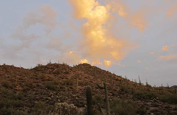 Light puffy clouds take on blazing colors in the late afternoon sun. |
 We reached Peralta Trailhead before sundown under a mackerel sky. |
|
“Petrified wildlife is my favorite kind for pictures,” he observes. “Animals run away before I can take their picture. Am I that scary? Anyway, I have nothing but admiration for wildlife photographers.” Everyone finishes the hike before sundown. |
| → More pictures and commentary, by Jim Buyens. |
| This hike is described in Footloose from Phoenix, by Ted Tenny, pages 167-177. |
 Top of Page
Comments? Send them to the AZHC .
updated November 18, 2019